Storm Jocelyn: People will ignore constant weather warnings, says chief forecaster
Daily weather warnings could lead to the public becoming complacent and ignoring them, a chief forecaster has warned.
Liz Bentley, the chief executive at the Royal Meteorological Society, said over the past week “probably not a day has gone by without a weather warning”.
“There are so many of those, the concern is that people might become complacent.”
She added that “if we constantly have yellow warnings out for something people will start to ignore them”.
Parts of Scotland and large parts of England are under a yellow weather warning for rain and wind as the impacts of Storm Jocelyn are felt.
The northern and western fringes of Scotland are also under an amber warning for wind until Thursday.
Yellow warnings are issued when there is a potential for low-level disruption from extreme weather.
Ms Bentley said it was important that the public understood whether they were likely to be impacted by the weather, and exactly what action they needed to take.
Jocelyn is the 10th named storm since September, making it the busiest season since the practice began in 2015.
Two people were killed and thousands left without power at the beginning of the week as Storm Isha hit the UK.
A third man is believed to have died after falling into a hole left by roadworks when safety measures were blown away.
Storms are named by the Met Office when the weather reaches the threshold to cause disruption or damage which could result in an amber or red warning.
ScotRail announced that no trains would run after 7pm until Wednesday, when it would have a chance to assess possible damage from the storm.
National Rail, which determines whether lines are closed, said it has a team of meteorologists who provide “around-the-clock analysis” on how the weather may affect Scotland’s Railway and inform their decision-making during storm events.
“Having two named storms back-to-back means trees weakened by Isha are now more likely to fail during Jocelyn so we are proactively managing that risk by a phased withdrawal of services before the worst of the weather arrives,” a spokesman said.
Ms Bentley said naming storms was an effective tactic to ensure the public was aware of the possible risks of extreme weather, and had been proven to reduce damage.
But she added that there was a legitimate “concern that a named storm becomes less of an event”, when there are so many of them.
Andrew Charlton-Perez, a professor of Meteorology at the University of Reading, said the frequency of named storms also presents a risk “that people become desensitised and might not take action that would minimise the impact”.
A study led by Mr Charlton-Perez in 2019 found that the public are more likely to take action to respond to a storm if it has been named.
But he said there was ongoing research on whether the frequency of named storms made a difference to people’s motivation to take action.
“It’s really tricky to achieve that balance,” he said.
Steve Willington, chief meteorologist at the Met Office, said Storm Jocelyn, named by Met Eireann, could cause more disruption than Storm Isha.
He said: “Although this system will be a step down relative to Storm Isha, with the damage and clean-up still under way, we could potentially see more impacts from Storm Jocelyn.
“Outbreaks of heavy rain on Tuesday could bring rainfall accumulations of 15 to 20mm quite widely with 40 to 50mm over higher ground in south-west Scotland, the Scottish Highlands and parts of north-west England.
“Wind gusts are expected to reach 55 to 65mph across northwestern Scotland while there is potential for winds to reach 75 to 80mph in a few places, in particular exposed parts of the Western Isles and coastal north-west Scotland early on Wednesday morning.”
07:12 PM GMT
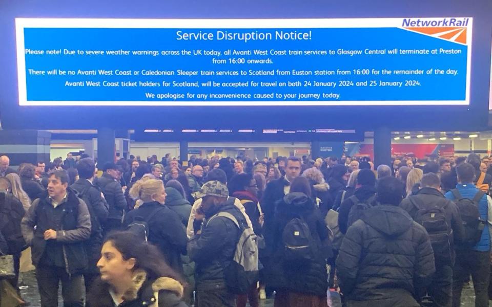
Avanti West Coast services from Euston now terminating at Preston
Avanti West Coast services travelling from London Euston to Scotland will now be terminating at Preston, according to service disruption notices shown at the station.
A public service announcement at the major terminus read: “Due to severe weather warnings across the UK today, all Avanti West Coast train services to Glasgow Central will terminate at Preston from 16:00 onwards.
“There will be no Avanti West Coast or Caledonian Sleeper train services to Scotland from Euston station from 16:00 for the remainder of the day.”
The sign informed commuters that tickets for Avanti West Coast services bound for Scotland would be valid for travel on Jan 24 and Jan 25 instead.
07:03 PM GMT
Operator says 14,000 customers have lost power in Storm Jocelyn
A further 14,000 customers have lost power following high winds caused by Storm Jocelyn, the Energy Supply Board has said.
The loss of power followed widespread outages on Sunday, as a result of Storm Isha, with 24,000 customers remaining without supply since the first bout of extreme weather.
As of 5:15pm on Tuesday, approximately 221,000 homes, farms and businesses have had their power restored, according to the operator.
A statement on their website said that repair efforts in the North West had been slowed by amber and yellow wind warnings, meaning some customers will remain without power for a number of days.
06:28 PM GMT
Storm Jocelyn: A round-up of what is to come
The Met Office has said Storm Jocelyn would bring heavy rain and strong winds across much of the UK on Tuesday and Wednesday.
As the worst of the rain begins to subside, three wind warnings remain in place for Tuesday night into Wednesday morning. They are:
Amber wind warning - western and northern Scotland (from 6pm on Tuesday to 8am on Wednesday)
Affected areas: Grampian, Highlands & Eilean Siar, Orkney & Shetland and Strathclyde
Forecast: Strong west or southwesterly winds from 6pm on Tuesday evening to 8am on Wednesday morning
Wind speeds: 55-65 mph gusts are likely, while exposed parts of the Western Isles and coastal northern Scotland may experience top speeds of 75-80mph
Met Office warning: Risk of power cuts, impacted mobile phone coverage, building damage, longer journey times and cancellations (across road, rail and air), road and bridge closures and danger to life from large waves in coastal areas
Yellow wind warning - across much of England and Wales (from 12pm on Tuesday to 3pm on Wednesday)
Affected areas: East Midlands, east of England, London & south-east England, north-east England, south-west England, Wales, West Midlands and Yorkshire & Humber
Forecast: Strong winds and localised disruption forecasted from midday Tuesday until 3pm Wednesday, peaking overnight.
Wind speeds: 45-55 mph gusts are likely inland, possibly 65mph on exposed coastal regions
Met Office warning: Risk of bus, train, road, air and ferry disruptions, spray and large waves in coastal regions and delays for high-sided vehicles on exposed routes and bridges
Yellow wind warning - across several parts of the UK (from 4pm on Tuesday to 1pm on Wednesday)
Affected areas: Central, Tayside & Fife, East Midlands, north-east England, north-west England, Northern Ireland, south-west Scotland/ Lothian Borders, Wales, West Midlands and Yorkshire & Humber
Forecast: Strengthening west or southwesterly winds from 4pm on Tuesday to 1pm on Wednesday
Wind speeds: 55-65 mph gusts widely expected, with possibility over 70mph winds in exposed regions
Met Office warning: Risk of road and bridge closures, building damage, power cuts, impacted mobile phone coverage, road, rail, air and ferry services impacted and danger to live from large waves in coastal areas
04:54 PM GMT
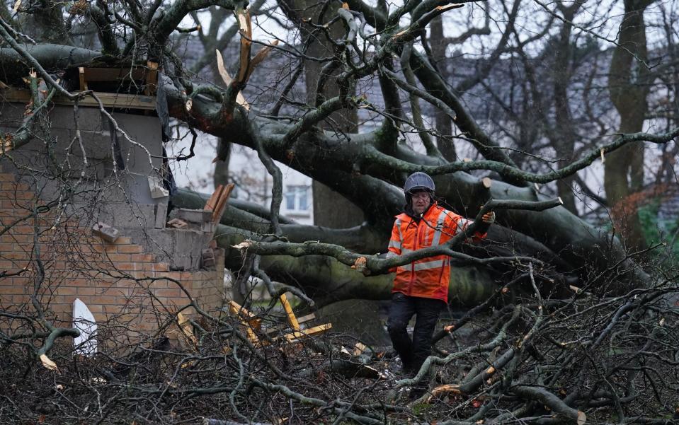
Police appeal for witnesses after two seriously injured by tree
Police are appealing for witnesses after two people were seriously injured by a tree on a road close to Bristol on Sunday.
A woman in her 50s is said to be in a life-threatening condition, while a man in his 60s suffered potentially life-changing injuries in the incident, which occurred at 7:30pm on the B3134 Broad Road near Blagdon, police have said.
Both are receiving treatment for serious head injuries at Southmead Hospital in Bristol.
In a statement, Avon and Somerset Police said: “Two people were seriously injured after a car either collided with a fallen tree or was struck by it as it fell at around 7.30pm.”
“We’re interested in speaking to anyone who witnessed the incident or who has dashcam footage of it, who hasn’t yet spoken to police.”
The constabulary have made a specific appeal for a motorist they believe was travelling in the opposite direction, and left the scene before police arrived, to come forward.
We're keen to speak to a motorist who we believe witnessed an incident involving a fallen tree on the B3134 Broad Road, near Blagdon on Sunday.
Two people were seriously injured.
If you witnessed what happened, or have footage, phone 101 ref 5224017763.https://t.co/nmG5ukiXzi— Avon and Somerset Police (@ASPolice) January 23, 2024
04:51 PM GMT
Flooding is impacting the 'nation's waterway heritage'
The charity that maintains more than 2,000 miles of canals and navigable rivers in the UK says it is counting the cost of the recent barrage of storms on the nation’s waterways.
The Canal & River Trust said it is braced for a mammoth clear-up operation as floodwater levels begin to recede.
At Naburn Locks, near York, the entire complex has been submerged for weeks.
A Canal & River Trust spokeswoman said: “Extreme weather has battered the country, including the nation’s 250-year-old canal network.
“As water levels recede, and another clear-up under way, the Canal & River Trust is counting the cost to our nation’s unique waterways heritage.
“Today, Naburn Locks is facing one of its greatest challenges in its 267-year history as sustained heavy rainfall has left the site under water for weeks.”
04:16 PM GMT
What we know about Storm Jocelyn so far
Rail passengers have been urged not to travel between England and Scotland on Tuesday afternoon as the UK braces for 80mph winds brought by Storm Jocelyn.
Several operators including Avanti West Coast, CrossCountry, LNER, Lumo, ScotRail and TransPennine Express have urged travellers to expect major disruption throughout Tuesday.
Storm Jocelyn is set to bring more travel chaos only a day after Storm Isha battered the UK with 99mph winds, leaving two dead and nearly a hundred flights diverted.
Tens of thousands in England, Scotland and Northern Ireland spent a second night without power because of the damage caused by Storm Isha.
The Met Office has issued amber and yellow weather warnings for wind across much of the UK as well as yellow warnings for rain covering parts of western and southern Scotland, and the north west of England. A yellow warning for ice was also issued for parts of northern and eastern Scotland.
Gusts of 80mph could be seen in exposed areas, with 40-50mm of rain possible over higher ground, according to the forecaster.
03:54 PM GMT
Wind speeds expected to pick up this evening
Met Office spokesman Stephen Dixon said Tuesday will be another wet day before wind speeds start to pick up towards the evening.
“Tuesday will be quite a wet day for many people with a rain front bringing the chance of disruption,” he said.
“Higher wind speeds will start to develop overnight on Tuesday into Wednesday morning.
“Wind speeds from Storm Jocelyn will be a slight notch down from Storm Isha, but with the clean-up still under way, more disruption is likely.”
Temperatures are expected to remain mild.
#StormJocelyn is here 🌀 pic.twitter.com/eTUeJ3HQjj
— Met Office (@metoffice) January 23, 2024
03:46 PM GMT
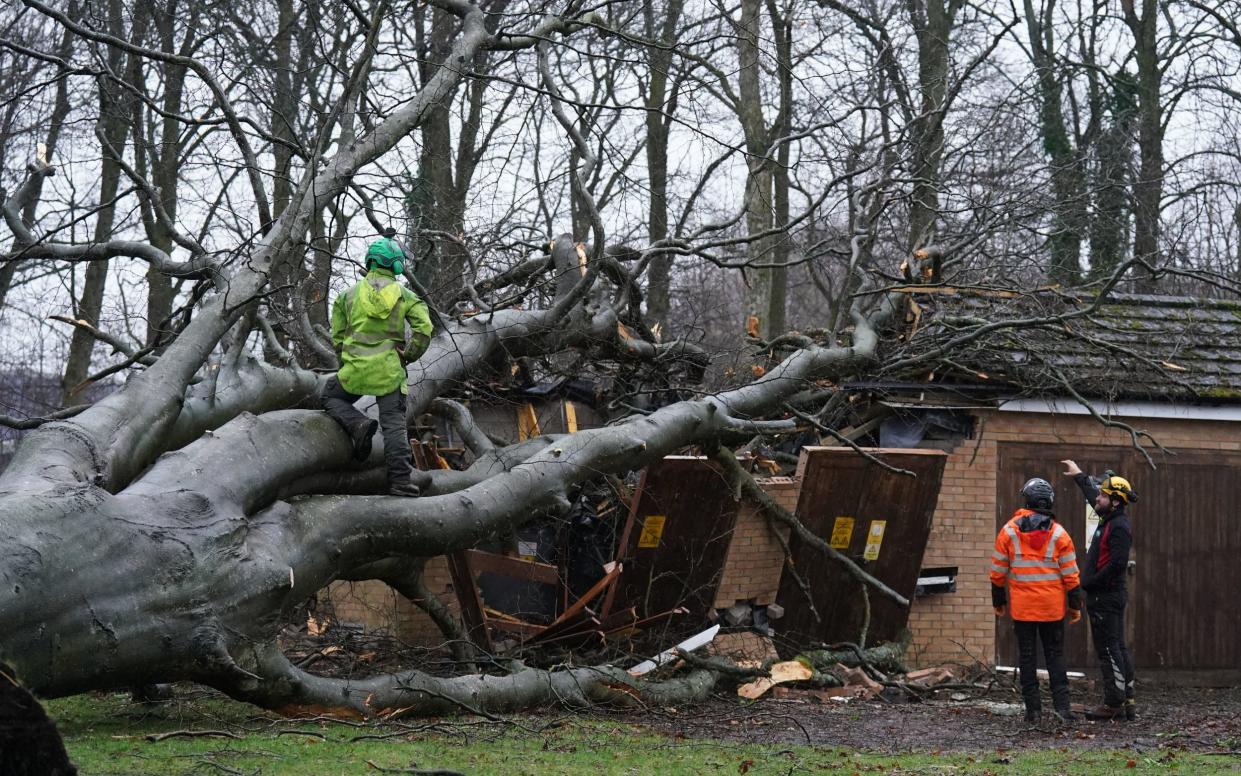
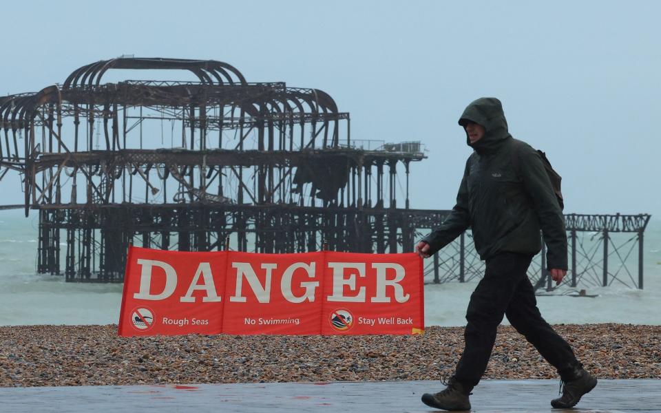
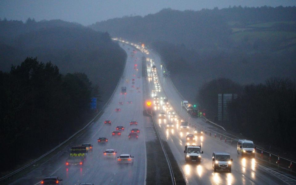
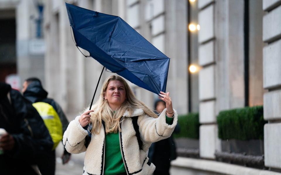
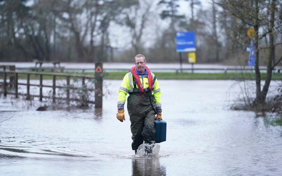
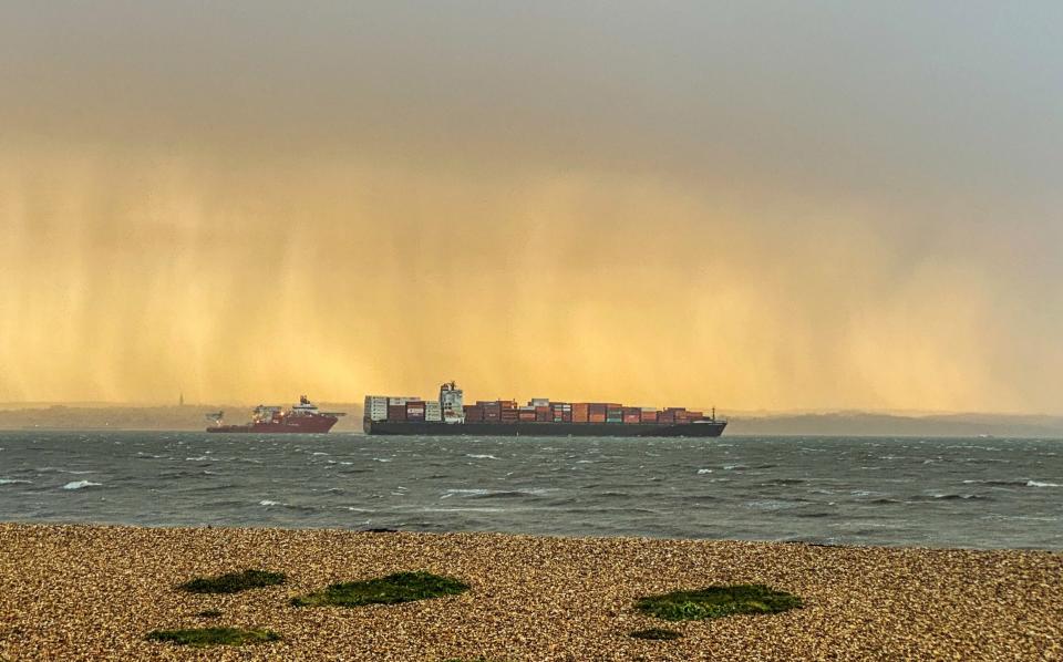
Pictured: Stormy scenes across the UK
03:37 PM GMT
What does the Met Office's chief meteorologist say?
Steve Willington, chief meteorologist at the Met Office, confirmed Storm Jocelyn could cause further disruption hot on the heels of Storm Isha.
He said: “Although this system will be a step down relative to Storm Isha, with the damage and clean up still underway, we could potentially see more impacts from Storm Jocelyn.
“Outbreaks of heavy rain on Tuesday could bring rainfall accumulations of 15 to 20mm quite widely, with 40 to 50mm over higher ground in southwest Scotland, the Scottish Highlands and parts of northwest England.
“Wind gusts are expected to reach 55 to 65mph across northwestern Scotland while there is potential for wind gusts to reach 75 to 80mph in a few places, in particular exposed parts of the Western Isles and coastal northwest Scotland early on Wednesday morning.”
03:28 PM GMT
How and why do storms get named?
The Met Office has been naming storms since 2015, when they launched their Name our Storms project.
The practice has long been used in the US, however, with tropical storms first being named during the 1950s.
Why?
A new shortlist is issued each September, containing the names that will be used for that year’s storms, with the idea being that the public responds better to weather safety messages using one recognisable, universal name.
The Met Office have said that “using a single, authoritative system provides a consistent message and aids the communication of approaching severe weather through media partners and government”.
How?
In the UK, storms are named when they are believed to have the potential to cause disruption or damage which could result in an amber or red warning, the Met Office have said.
The national weather service works in conjunction with the Met Éireann, the Irish meteorological service, and the KNMI, the Dutch national weather service, as a western storm-naming group.
If the criteria to name a storm has been met, a name will be taken from the latest list, working in alphabetical order.
The three weather services compile this list ahead of time with input from members of the public, who can submit names for consideration.
For the first time, the Met Office has chosen to name a number of storms in the 2023-24 season after prominent scientists and meteorologists, with Storm Jocelyn inspired by Prof Jocelyn Bell Burnell, an astrophysicist who discovered pulsating radio stars in 1967.
The shortlist of 2023-24 storm names and the date they impacted on the UK, Ireland or the Netherlands
Agnes (Sep 27-28 2023)
Babet (Oct 18-21 2023)
Ciarán (Nov 1-2 2023)
Debi (Nov 13 2023)
Elin (Dec 9 2023)
Fergus (Dec 10 2023)
Gerrit (Dec 27-28 2023)
Henk (Jan 2 2024)
Isha (Jan 21-22 2024)
Jocelyn (Jan 23-24 2024)
Kathleen
Lilian
Minnie
Nicholas
Olga
Piet
Regina
Stuart
Tamiko
Vincent
Walid
02:39 PM GMT
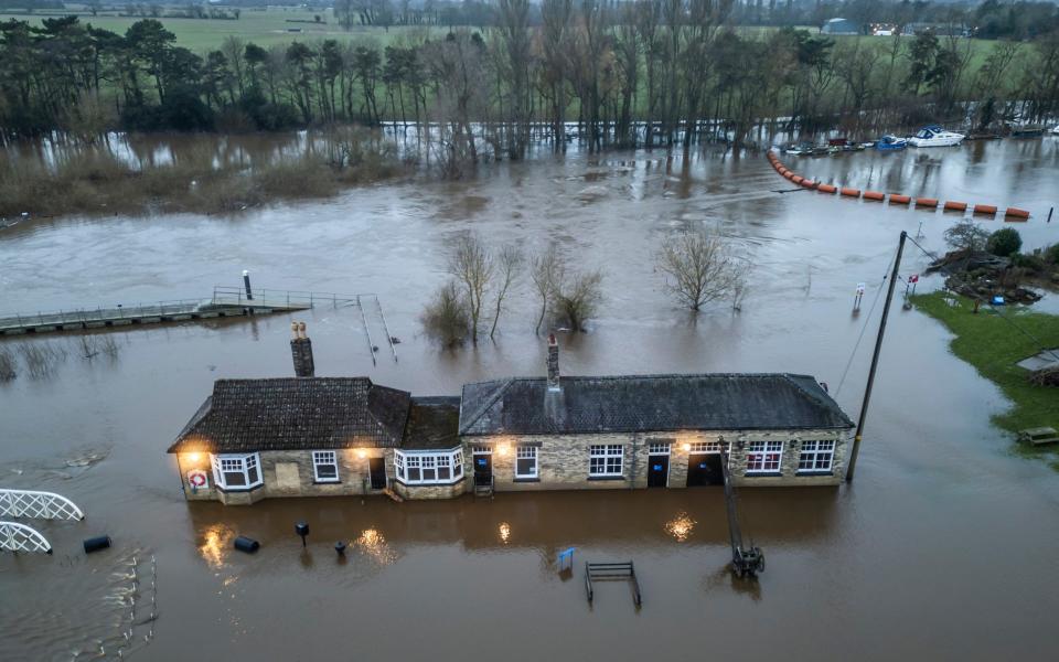
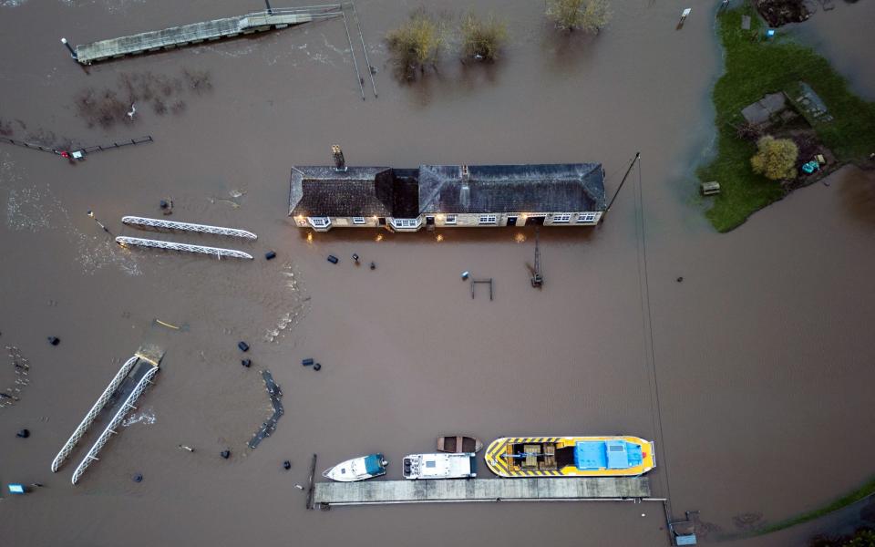
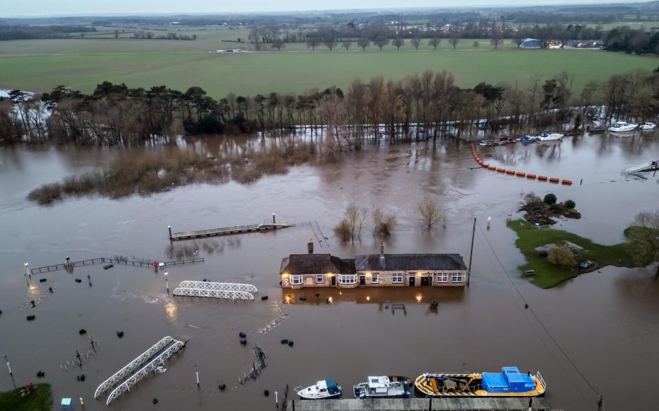
Pictured: Flooding in York

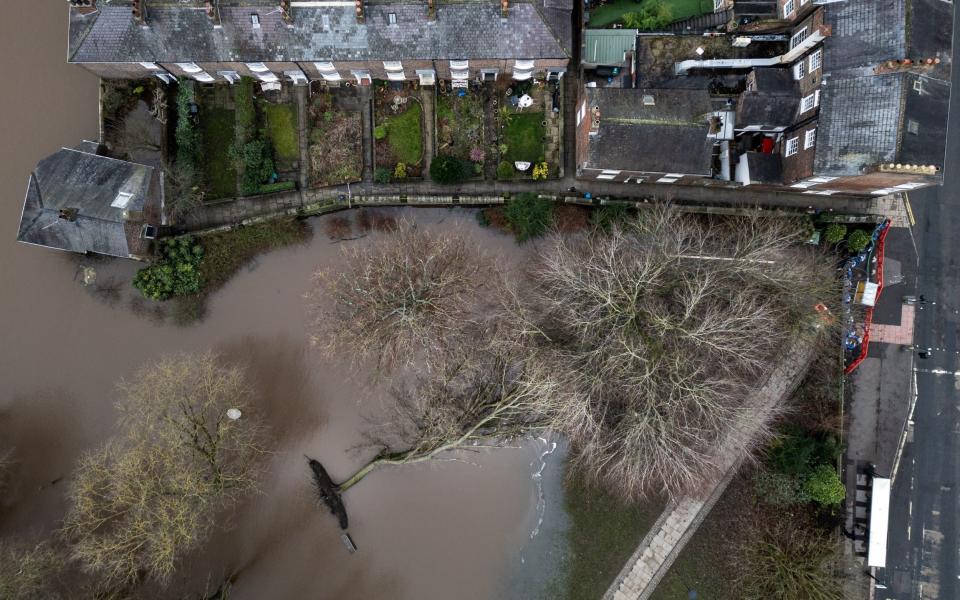
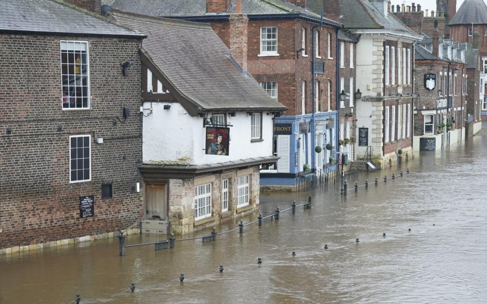
A building is shown immersed in flood water at Naburn Lock, on the outskirts of York, after Storm Isha brought heavy rain to the UK.
Parts of the city have been left flooded after extreme weather on Monday night, and the Met Office have issued eight further flood warnings across North Yorkshire as the county braces for Storm Jocelyn.
At 11am, the River Ouse was recorded to have reached 3.74m and rising. The river’s normal water level is 2.9m.
Flooding is forecast to affect low-lying land around the river, particularly the Naburn Lock Buildings and Lock Cottages.
Tadcaster Bridge, which spans the River Wharfe and serves as the main route connecting two sides of the town, has also been closed to vehicles since Monday morning, after river levels became dangerously high.
02:15 PM GMT
Passenger and freight services closed in Scotland from 7pm
No passenger or freight services will run in Scotland after 7pm as Storm Jocelyn sweeps in, bringing more heavy wind and rain to the country.
Trains still running at this time will complete their journeys at a reduced speed.
Rush hour services have also been suspended for Wednesday morning because of the expectation of extreme weather over the next 24 hours and the possibility tracks will need to be cleared of fallen trees of debris.
The Met Office has issued yellow weather warnings for wind covering much of the UK, with an amber wind warning covering the west coast of Scotland, parts of the north and north east and Orkney between 6pm on Tuesday until 8am on Wednesday.
There are also yellow warnings for rain covering parts of western and southern Scotland and a yellow warning for ice has been issued across northern and eastern parts of Scotland.
ScotRail said their infrastructure had already been “significantly impacted” by Storm Isha, which passed only yesterday, and it predicted Storm Jocelyn will create more challenges across the network.
⛔️ REMINDER. Given the extraordinary number of incidents caused by the ferocity of Storm Isha, and the likelihood of more damage to our railway as #StormJocelyn’s winds follow so closely behind, we’ve decided to shut down all passenger and freight services from 19:00 tonight.
— Network Rail Scotland (@NetworkRailSCOT) January 23, 2024
02:06 PM GMT
RAC urges drivers to postpone journeys in storm-affected areas
Drivers are being urged to consider postponing journeys and avoid parking under trees in parts of the UK expected to be hit by Storm Jocelyn.
RAC spokesperson Alice Simpson said: “With so much heavy rainfall and debris on the roads, driving conditions will be very challenging, especially across northern parts of the country where the weather is at its worst.
“Visibility will be severely reduced due to the spray from lorries and other large vehicles, and the amount of water on the roads will increase stopping distances.
“We urge drivers to consider postponing their journeys in these areas if at all possible. Those that do need to drive should try to avoid exposed coastal routes where strong winds will make driving much more difficult.
“The best advice is to slow down significantly, leave plenty of room behind the vehicle in front and be aware of unexpected obstructions en route like fallen trees and branches, particularly on rural roads.
“We also suggest drivers avoid parking underneath or near to trees.”
12:49 PM GMT
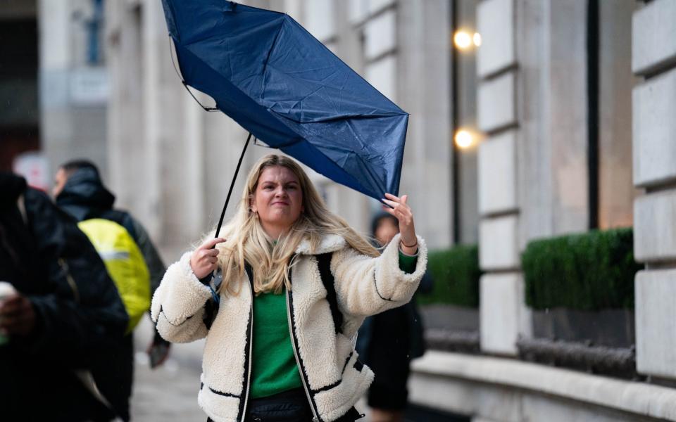
Pictured: Calm before the storm

12:42 PM GMT
TransPennine Express warns commuters to avoid certain routes
TransPennine Express has warned commuters to avoid certain routes between 3pm on Tuesday and midday on Wednesday because of yellow and amber weather warnings.
The train operator is advising not to travel between Preston and Glasgow or Edinburgh, or from Newcastle to Edinburgh, while the weather warnings remain in place.
⚠️🌧️ #StormJocelyn Update
Due to yellow and amber weather warnings, we're advising not to travel from 15:00 on Tuesday 23 January until 12:00 on Wednesday 24 January between:
- #Preston to #Glasgow
- #Preston to #Edinburgh
- #Newcastle to #Edinburgh— TransPennine Express (@TPExpressTrains) January 23, 2024
12:35 PM GMT
Power restoration efforts continue
Efforts to restore power to customers have continued in Northern Ireland and the Republic of Ireland in the aftermath of Storm Isha, with warnings of further disruption to come from Storm Jocelyn.
Approximately 7,000 homes in Northern Ireland and 57,000 in the Republic of Ireland are still without power as a result of damage caused by the first storm.
The latest extreme weather is expected to bring gusts of up to 65mph from around 4pm.
Stormont’s Department for Infrastructure said multi-agency partners have been working around the clock to restore electricity supplies damaged by falling trees.
A spokesperson said: “Storm Jocelyn is expected to bring strong winds from 4pm today and a yellow Met Office warning has been issued and will remain in place until 1pm on Wednesday.
“The advice is to consider if your journey is necessary and to be aware there is a high risk of fallen trees, branches or other debris on the road.
“Where roads are closed people are reminded to adhere to road signs and follow any diversions in place.”
12:28 PM GMT
Storm damage forces major Northern Ireland attraction to close
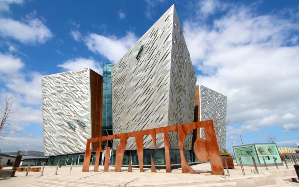
One of Northern Ireland’s most popular visitor attractions has been closed to the public because of storm damage.
In a social media post, Titanic Belfast confirmed that it had closed its doors to safeguard public and staff.
It said: “Due to damage caused to its roof during Storm Isha and further inclement weather from Storm Jocelyn preventing safe access to the roof, Titanic Belfast has taken the decision to close, to safeguard the public and its staff and to allow for further assessment of the damage.
“The safety of the public and its staff are Titanic Belfast’s priority and as such access to the building is closed and customers are being asked not to come to the site.
“We apologise for the inconvenience caused.”
12:17 PM GMT
Met Office: What to expect from Storm Jocelyn
A yellow weather warning has been issued by the Met Office, with warnings of heavy rain across parts of Wales between 12:30pm and 7pm on Tuesday.
The weather service has said Storm Jocelyn could bring:
Further power cuts and impacted mobile phone coverage
Damage to buildings and flying debris
Longer journey times and cancellations across rail, air and ferries
Road and bridge closures
Large waves posing an injury risk and danger to life in coastal areas
Follow our blog as we continue to bring you live updates.
⚠️ Yellow weather warning issued ⚠️
Heavy rain across parts of Wales
Tuesday 1230 – 1900
Latest info 👉 https://t.co/QwDLMfRBfs
Stay #WeatherAware⚠️ pic.twitter.com/lIdFegkOTp— Met Office (@metoffice) January 23, 2024
11:15 AM GMT
Rail passengers urged not to travel
Rail passengers have been urged not to travel between England and Scotland on Tuesday afternoon as the UK braces for 80mph winds brought by Storm Jocelyn.

