After the storm report card: How our Ontario snowfall forecast fared
Since Tuesday, we've been letting you know about a significant snowfall across southern Ontario.
No snowfall forecast achieves absolute perfection. Marginal surface temperatures, variable snowfall rates and how wet the snow is all play a pivotal role in the ultimate totals.
RELATED: PHOTOS: Winter storm illuminates skies and buries roads in Ontario
So, how did we do?
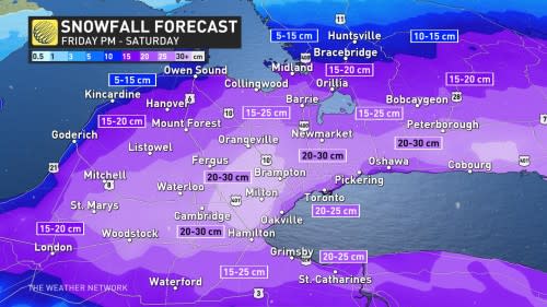
Most regions fell into our snowfall ranges on our advertised products and graphics. A swath of 20-30 cm was verified away from Lake Ontario and along the 401 corridor.
Some locations in the eastern Greater Toronto Area (GTA) and near Stouffville look to have even overachieved by a couple centimetres.
Areas that performed the worst in terms of verification include the lakeside communities of Burlington and downtown Hamilton. A meagre 1°C made all the difference.
Snowfall ranges varied like a typical Vancouver snowstorm. It made forecasting a tremendously challenging task.

Amounts above and below the escarpment in Hamilton varied by nearly 20 cm, over very short distances.
The easterly wind off the three-degree Lake Ontario water temperature made all the difference, and pairing that with 100-metre elevation changes was all that was needed to turn slush into 20 cm of snow. If this were dry, fluffy snow, we'd push closer to 50 cm of snowfall across the highest-hit regions.
The wet snow caked stop lights, creating travel headaches. Remember to clear your catch basins as temperatures spike above the freezing mark through the weekend.

