Storm reports: Deadly winter storm spreads snow, ice into mid-Atlantic
As of 9 p.m. EST Sunday, this reports story is no longer being updated. To view photos of the winter storm, click here.
While snow tapers off across Missouri, Illinois and Indiana on Sunday, residents of the mid-Atlantic will face power outages, slick roads and travel delays as snow and ice continue to pile up on Sunday.
Heavy snow blankets central, northeastern United States
AP Photo/Garret Fischer


First, at vero eos et accusamus et iusto odio dignissimos ducimus qui blanditiis praesentium et accusamus et iusto odio dignissimos ducimus qui voluptatum.


(Photo/Katie Barlow)

(Photo/@zoeica)

(Photo/Joe Banez)

(Photo/@realjad621)

A snowy flight into Baltimore.
(Photo/Ryan White)

(Photo/Jacki Wood)

(Twitter: @thunderhead_wx)

Ice caused this tree to snap in southwestern Missouri. (Photo/Debbie Wray)

(Twitter: @@mrslaws8417)

(Twitter: @AndyRossBaker)

(Twitter: @Kelian_NE)

(Photo/Brandon Kerr)

(Twitter: @thunderhead_wx)

(Twitter: @AndyRossBaker)

(Twitter: @AndyRossBaker)

(Facebook: Linda Schuder Brown)
Fulton, Missouri

(Photo/Andrew Carter)

(Photo/Jeff cox)

(Photo/@virgilkdowell)

(Photo/Emily Hughes)

A snowy farmer's market in Washington, D.C. (Photo/Lauren Katz)
The winter storm began to unfold over the region on Friday afternoon with heavy snow and freezing rain across Missouri and Kansas. Some motorists became stranded on the snow-covered roads for hours, and additional travel delays continued through Saturday.
At least four deaths have been reported in Missouri, according to the Missouri Highway Patrol. CNN reports an additional three deaths occurred in Kansas, while one fatal crash occurred in Illinois and another in Indiana. This brings the total storm death toll to nine.
Snow, sleet and freezing rain moved into the mid-Atlantic and Carolinas on Saturday evening. Roads quickly became slick and travel delays mounted.
The weight of the heavy, wet snow could cause some trees to snap, leading to sporadic power outages. The freezing rain event unfolding in the higher elevations of North Carolina and southwestern Virginia can also lead to widespread power outages.
Download the free AccuWeather app to see the start and end time of the storm as well as how much snow is predicted for your area.

8:30 p.m. EST Sunday:
Refreezing will occur overnight in many of the affected areas across the northeastern United States. Motorists should be cautious driving tonight and in the morning on the way to work.
Tonight's road menu - more salt! We're expecting melted snow to refreeze as temperatures drop, leading to icy, slick roads. Please continue to delay travel until after storm's end. Thank you for giving emergency responders and our crews room to work: https://t.co/aBsV2ON8yO pic.twitter.com/iGbA3BdJVf
— VDOT Fredericksburg (@VaDOTFRED) January 13, 2019
7:03 p.m. EST Sunday:
The metrobus in Washington, D.C. is temporarily suspending service on all routes and all lines due to icy, hazardous road conditions.
NEW: Metrobus suspended due to snow. https://t.co/IdhLifpc5O
— Capital Weather Gang (@capitalweather) January 14, 2019
6:15 p.m. EST Sunday:
Many roads in North Carolina were closed because of falling trees and icy conditions.
Virginia State Police said they responded to more than 230 traffic crashes and helped more than 100 disabled vehicles in Virginia from midnight to noon Sunday.
Since midnight, #Virginia troopers have assisted 196 disabled/stuck motorists and responded to 324 crashes statewide...like this one in #Loudoun Co. Fortunately no one injured. Plz delay travel until highways are clear & safe! @VaDOT @VaPSHS @VDEM pic.twitter.com/cR1lC1eTX0
— VA State Police (@VSPPIO) January 13, 2019
4:45 p.m. EST Sunday:
Snow has increased in intensity around Washington, D.C., where the official snowfall total is up to seven inches. Watch for continued slow and slippery travel through early tonight.
Over 500 flights now canceled around Washington, D.C. due to weather.
The snow is sticking around and reducing visibility at the airport. Ground crews are working hard to clear the runway & get everyone on their way. As always, we recommend double checking flight status with your airline prior to coming to the airport. Thanks for your patience! pic.twitter.com/MgUtDG1pup
— Reagan Airport (@Reagan_Airport) January 13, 2019
3:25 p.m. EST Sunday:
People around Washington, D.C. are taking advantage of the snow with cross-country skiers spotted at the National Mall. Most areas around the city have reported 4 to 8 inches of snow.
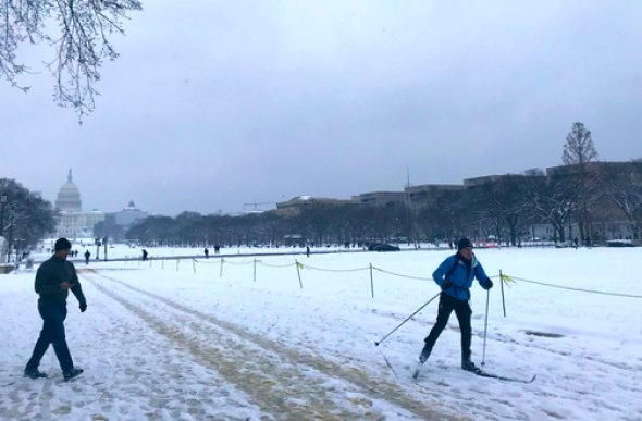
(Photo/Kelley Lane)
2:05 p.m. EST Sunday:
Power outages in North Carolina remain over 125,000 after ice glazes parts of the state. Western parts of the state recorded the worst of the ice with some spots south and east of Asheville measuring up to half an inch of ice.
Ice accumulation reports from this weekend's storm. pic.twitter.com/KlUiUgOmNj
— NWS Eastern Region (@NWSEastern) January 13, 2019
Trees and ice-laden branches on lines, like this one along HWY 68 in Oak Ridge are the main cause of @DukeEnergy outages in this storm. Icy, downed trees are also making work conditions challenging. Report outages by texting OUT to 57801. pic.twitter.com/4z1Aju07T2
— Jeff Brooks (@DE_JeffB) January 13, 2019
County Volunteer Fire Departments are dealing with hundreds of downed trees and many downed power lines. They're working closely with Duke Energy, but it will be a long process.
Please stay away from fallen power lines and beware of trees that may fall suddenly due to the ice. pic.twitter.com/Jup7zUDpwu— Forsyth County North Carolina (@ForsythCountyNC) January 13, 2019
12:38 p.m. EST Sunday:
Road crews are out and about in Virginia as they battle to keep the roads clear. Virginia Gov. Ralph Northam had declared a state of emergency on Saturday as the state prepared for the winter storm.
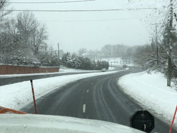
This photo shows improved road conditions across parts of northern Virginia. (Photo/Virginia Department of Transportation)
In case you want to know what it's like when we go Plows Down. Somehow we think you'll know the moment it happens. pic.twitter.com/zTLb81Rbqd
— VDOT Northern VA (@VaDOTNOVA) January 13, 2019
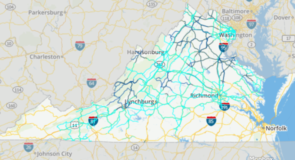
Road conditions range from minor (light blue) to moderate (dark blue) according to the Virginia Department of Transportation.
11:40 a.m. EST Sunday:
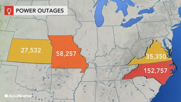
Missouri, Kansas, North Carolina and Virginia have the highest number of power outages from the winter storm as of 11:40 a.m. EST Sunday.
9:52 a.m. EST Sunday:
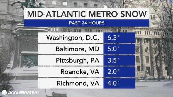
A look at the updated snowfall totals for major metropolitan areas in the mid-Atlantic region Sunday morning. This is already the largest snowfall of the year in the nation's capital and the biggest snowstorm in Washington, D.C. since January 2016.
9 a.m. EST Sunday:
A plane reportedly skidded off the runway at Cincinnati/Northern Kentucky International Airport earlier this morning. There were no reports of injuries.
@delta Little help? At CVG airport.... pic.twitter.com/XLx4vM98PY
— Brad Ritti (@BradRitti) January 13, 2019
According to FlightAware, there have been more than 1,000 flight cancellations today. More than 200 of those are from Reagan National Airport.
8:39 a.m. EST Sunday:
AccuWeather Extreme Meteorologist Reed Timmer is in Roanoke, Virginia, where sleet, freezing rain and snow continues to accumulate.
ICE STORM: freezing rain, sleet and snow with ice accumulations approaching 1/4" in Roanoke, VA area! DC continues with pure snow! Dangerous conditions here along I81 @breakingweather @accuweather #winterstormwarning #snow #vawx pic.twitter.com/26nq1yn3Db
— Reed Timmer (@ReedTimmerAccu) January 13, 2019
NEW: freezing rain accumulation over 1/4" in Roanoke, VA with very slippery conditions along I81 in southwest VA. Reports of power outages in western NC #icestorm @breakingweather @accuweather #vawx pic.twitter.com/4AWsCrLXbV
— Reed Timmer (@ReedTimmerAccu) January 13, 2019
8:10 a.m. EST Sunday:
The city of Richmond, Virginia, has activated its emergency operations center.
The COR Emergency Operations Center has been activated. We have 50+ trucks, tons of sand and salt on the roads. It's going to be a nasty day out there, so if you must go out, please take it slow and exercise caution and common sense!
— City of Richmond, VA (@CityRichmondVA) January 13, 2019
In New Jersey, department of transportation officials say there are more than 1,000 department and contractor plows and salt spreaders working in the central and southern parts of the state. Residents are urged to stay off the roads.
The New Jersey Turnpike has instituted a speed restriction of 45 mph for the entire length from the Delaware Memorial Bridge to the George Washington Bridge.
Crews were out treating snow-covered roads in Prince Georges County, Maryland, early Sunday morning.
As the snow continues to come down, here's a current look at the roads. This is Marlboro Pike, a primary road, in Upper Marlboro. DPW&T crews continue to plow the roads and treat them as needed. #Snow pic.twitter.com/jTUBdG9uP5
— PGCountyDPWT (@PGCountyDPWT) January 13, 2019
As of 8 a.m. EST Sunday, all storm reports will now be listed in Eastern time.
5:35 a.m. CST Sunday:
Heavy ice accretion across western North Carolina has now resulted in nearly 100,000 power outages.
Picture just doesn't do it justice. - East Flat Rock #ncwx #ice @NWSGSP pic.twitter.com/qGNiQZ5Jag
— Bryant Almany (@AlmanyDesigns) January 13, 2019
While snow showers are occurring in the New York City area, no accumulation is expected.
4:02 a.m. CST Sunday:
Power outage reports are nearing 50,000 in North Carolina, where freezing rain continues to glaze raised surfaces including trees and power lines.
Farther north, snow is starting to take a toll on area roadways. Slick roads and low visibility will make travel slow and dangerous on Sunday morning as crews work to plow and treat area roadways.
As of 4:15 AM: 3.5"+ of snow has fallen across PWC. Some primary roads are starting to become snow covered; most secondary roads and neighborhoods are snow covered. Please continue to stay off the roads and give @VaDOTNOVA room to work! Updates at https://t.co/9v4Xs2IHWW #VaWx
— Ready Prince William (@ReadyPWC) January 13, 2019
For previous reports on the winter storm, click here.
