'Storm of the season' dumps record-breaking rainfall on SoCal and snow in the mountains
Streets flooded in North Hollywood's Arts District and other neighborhoods.
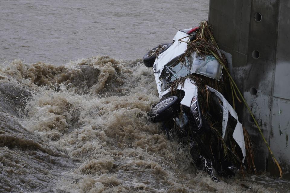
The normally constrained L.A. River roared to life, sucking vehicles down its surging waters and swamping the small islands that dot the middle of the urban waterway near Atwater Village. A man in Sylmar had to be rescued after he got swept up into its flow.
Trees were toppled in Whittier, while homeless people who normally occupy benches near the Civic Center stop downtown huddled in an alcove in an effort to stay dry.
The most significant storm of the season arrived in Southern California on Tuesday with a wallop — snarling traffic, delivering gusty winds and dropping a steady deluge of record-breaking rain and snow across the region.
"As far as intensity, it's one of our stronger storms," said Kristan Lund, a meteorologist with the National Weather Service in Oxnard. "It's definitely the strongest we've seen so far, and potentially one of the stronger ones we'll see this season."
The LA River is raging #LARiver #AtwaterVillage pic.twitter.com/EZANVwlNPb
— Cindy Chang 張心澤 (@cindychangLA) December 14, 2021
Despite the headaches storms bring to a region where the sun shines most days, the weather system marked a meaningful change for drought-parched California, which has in recent months seen snowpack and reservoir levels dwindle to near-historic lows amid a statewide drought emergency.
The state experienced its hottest summer on record this year, while Los Angeles had no rain last month — its driest November in nearly 30 years, according to the weather service.
Officials said Tuesday's rainfall on its own won't end the drought, but it was an improvement.
"This just brings us back to slightly above normal," said David Gomberg, a meteorologist with the National Weather Service in Oxnard. "We're just trying to catch up to what even normal is for this time of year. It would take a few of these [storms] to really make a significant dent."
By day's end, 1 to 2 inches of rain had fallen across most parts of Los Angeles, while other areas of the state received even more. Parts of Santa Barbara County saw more than 7 inches, and Woodland Hills surpassed 4 inches by noon.
The National Weather Service said the slow-moving storm broke several rainfall records for the date. With more than 2 inches of rain by noon, downtown Los Angeles far surpassed its previous Dec. 14 record of 0.96 inches set back in 1888.
By nightfall, the weather service's Oxnard office confirmed new daily records for seven locations from Los Angeles to Santa Maria, including 0.72 inches of rain in Lancaster, nearly triple the previous record of 0.25 inches in 1970; 1.29 inches at Los Angeles International Airport, smashing the 0.38-inch mark set in 1993; and 1.81 inches at Hollywood Burbank Airport, more than six times the record of 0.29 inches set in 1965.
Precipitation records for the day were also broken in Orange County, according to the weather service's San Diego office. Anaheim received 1.38 inches of rain, breaking the old record of 0.24 inches set in 2015. Santa Ana saw 1.63 inches of rain, breaking the record of 0.80 inches set in 1934.
Some residents took to social media to celebrate the arrival of precipitation.
"I was up at 4:30 just to listen to the beautiful rain here in L.A.," one person said on Twitter.
The storm also delivered on its threat of hazards, creating a mess of the morning and afternoon commutes as crashes and road closures piled up.
Throughout the day, the weather service's advisory map was lit up with an array of alerts, including winter storm warnings, high wind warnings, flash flood watches and gale warnings off the coast.
One video posted to Twitter showed a massive tree that had fallen in Whittier, littering a residential street with a tangle of branches, leaves and oranges. In elevated areas of Griffith Park, thick clouds limited visibility to about 50 feet.
In Sylmar, a man was swept into a small tributary of the L.A. River and carried about half a mile into a tunnel, where he was rescued by the Los Angeles Fire Department.
Meanwhile, multiple vehicles were reportedly swept into the river and carried downstream.
In Riverside, firefighters rescued five adults and two cats from the Santa Ana River at the Mission Inn Avenue bridge, authorities said on Twitter.
In Rosemead, foam cups, paper products, two uprooted trees and other debris washed up from a swollen channel onto the Rio Hondo trail. The lowest points of the walking and bicycling path, primarily under bridges, flooded as rain fell in droves.
Reports of shallow mud and debris flows emerged from areas near wildfire burn scars, including the recent Alisal fire in Santa Barbara County and 2020's El Dorado fire in San Bernardino County. Firefighters in Orange County rescued trapped residents after the storm triggered multiple mudflows in Silverado Canyon.
And in the mountain community of Wrightwood, the storm brought substantial wind, rain and snow that caused some residents to be without power until the afternoon.
Therese Leonard-Viramontes, who has lived in Wrightwood almost 12 years, said her husband was standing outside Tuesday morning when the roaring wind snapped in half two trees, including a 30-foot blue spruce, in their yard. The wind also pushed their neighbors’ travel trailer onto its side.
Leonard-Viramontes, 69, said she and her family were stunned as they watched from their living room.
“It was like a small tornado that came right through here,” she said. “You can see the destruction in its path.”
Latest storm details. The steady rain is moving to the east of Los Angeles County, as we transition into more off and on again showers for the rest of the day. Some showers could produce heavy rain, gusty winds, and lightning. Be extra careful on the roads. #cawx #larain pic.twitter.com/LYPTB1JlVe
— NWS Los Angeles (@NWSLosAngeles) December 14, 2021
The massive storm arrived from the Pacific, first drenching the Bay Area on Monday and then moving down the coast, unleashing bursts of heavy rain, fierce winds and, at times, hail. In Carmel Valley, a mudslide deposited boulders onto a road.
"It will take a while for the roads to clear," said Jeff Lorber, a meteorologist with the weather service's Bay Area station.
The storm also dumped as much as 6 feet of snow between the Lake Tahoe area and Mammoth Mountain, and as much as 3 feet in the mountains around L.A. County, where snow levels lowered to nearly 2,500 feet.
Those driving through the Grapevine area of the 5 Freeway might have been less thrilled by the arrival of the powder, which slowed traffic in some areas to a crawl, but it marked a welcome reversal of fortune for ski resorts across the state, several of which delayed their openings due to the notably dry November.
The band of moisture was traveling slowly through the area, “and the slow movement allows it to keep producing snow,” said Shane Snyder, a meteorologist with the weather service’s Reno station.
The Sierra Avalanche Center warned that heavy snow was overloading a weak existing snowpack, allowing for “very wide avalanches” that can crash into forests. Snowpack totals this year have been dismal, with researchers recently finding that winters of low snow — or even no snow — could become a regular occurrence in the state in as little as 35 years.
Tuesday's combination of heavy snowfall and gusty winds prompted a winter storm warning for portions of the mountains in Ventura and L.A. counties through the evening.
Wind gusts of up to 65 mph were blowing in the mountains and Antelope Valley. The Magic Mountain Truck Trail saw isolated gusts of more than 90 mph.
The storm tapered off in Los Angeles by the evening, with Wednesday slated to be "a mostly sunny and dry day," forecasters said.
Times staff writers James Queally, Andrew Campa, Jaclyn Cosgrove and Gregory Yee contributed to this report.
This story originally appeared in Los Angeles Times.

