Flooding possible in Wilmington into Saturday as Tropical Storm Ophelia strengthens
Conditions across the Wilmington area have started to deteriorate as Tropical Storm Ophelia makes its approach. As a result, projected winds and rainfall have accelerated.
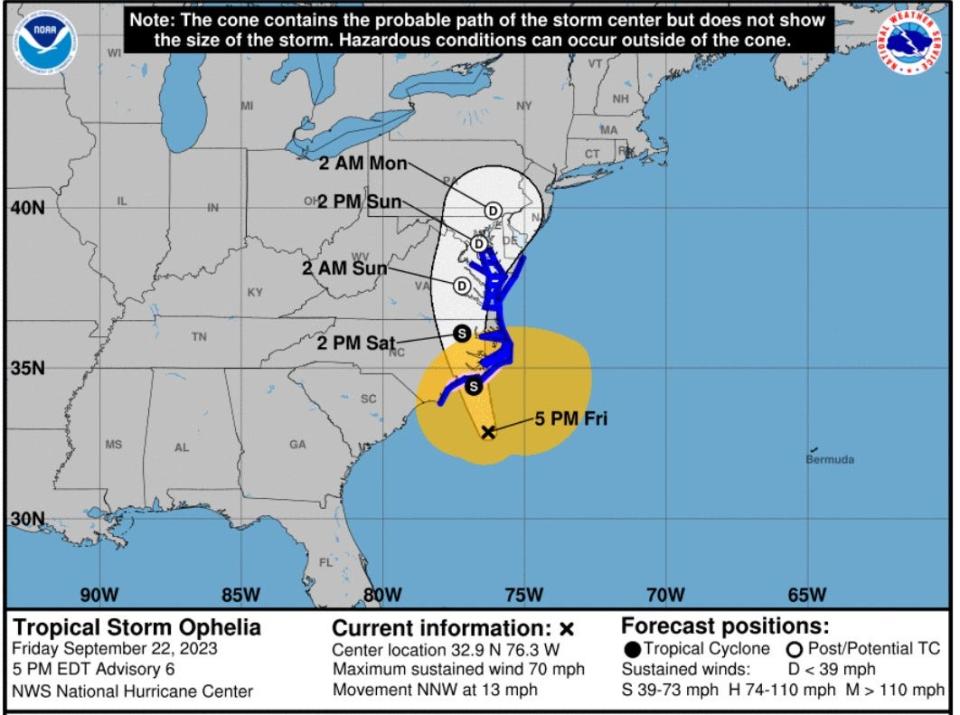
According to the National Hurricane Center, hurricane hunters found the storm continues to strengthen and by Friday afternoon packing sustained winds just below hurricane level at 70 mph with higher gusts. An advisory showed the storm is located 120 miles southeast of the Wilmington area and about 165 miles south-southwest of Cape Hatteras. The storm is currently moving north-northwest at 13 mph.
According to a news release, Governor Roy Cooper signed an executive order declaring a state of emergency to prepare for the storm’s impact. Forecasters with the National Hurricane Center expect the storm to make landfall on the North Carolina coast and then move across eastern North Carolina, southeastern Virginia, and the Delmarva Peninsula Saturday and Sunday.
This is not the first time North Carolina has experienced a storm with the name Ophelia. A hurricane with the same name caused damage across the Wilmington area in 2005.
Here’s the latest on what to expect in the area, according to the National Weather Service Office in Wilmington.
TRACK THE STORM: See the latest path.
Wind
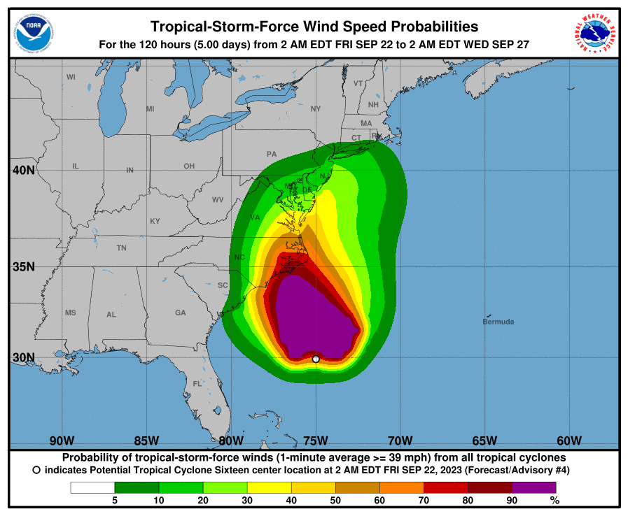
Tropical storm conditions are expected throughout Friday and spread northward into Saturday. As the storm continues to strengthen, a hurricane watch has been issued for the coast of North Carolina north of Surf City to Ocracoke Inlet.
More: With tropical storm conditions expected in Wilmington, here's what's closed
Rainfall
The National Weather Service updated rainfall totals for the area, with 6 to 8 inches possible across portions of Pender and New Hanover counties, and 3 to 6 inches possible inland. All three counties are now under a flood watch. Forecasters with the National Weather Service Office in Wilmington say the amount of rainfall is likely to bring the Northeast Cape Fear River at Burgaw into minor flood stage during the weekend.
Surf
Swells generated by this system will be affecting much of the East Coast of the United States through the weekend. These swells are likely to cause life-threatening surf and rip current conditions, the hurricane center said. A high surf advisory is in effect for Wilmington area beaches.
Storm surge
The National Weather Service in Wilmington is predicting low impacts from storm surge for area beaches. This could include ocean overwash with water reaching the dunes and flooding of low-lying areas along the shore and tidal creeks. Overall, storm surge inundation of one to three feet is expected. A storm surge watch is in effect for Surf City north to Duck.
More storm coverage
More: Will Wilmington-area schools close because of the storm?
More: Complete coverage of Hurricane Idalia's impacts on the Wilmington area
More: Check the latest weather conditions via these webcams along the NC coast
More: What are the 5 worst hurricanes to ever hit the Wilmington area?
This article originally appeared on Wilmington StarNews: Tropical storm warnings for NC coast, rain, wind for Wilmington

