Still a chance the system parked off coast could become named storm


A large storm that will remain stalled just off the Atlantic coast into Wednesday will continue to create stiff winds and rough surf, prior to turning westward later this week, when it will deliver downpours in the Southeast. This storm, which brought tornadoes and flooding rain to the mid-Atlantic and central Appalachians last week, could even become the very first subtropical depression or named system of the 2022 Atlantic hurricane season, according to AccuWeather meteorologists.
On Tuesday, impacts from this stalling storm continued to be felt from the New Jersey coast to the North Carolina Outer Banks in the form of high wind gusts as well as rough surf, strong rip currents, beach erosion and flooding. In the North Carolina coastal city of Hatteras, winds blew steadily between 15 and 20 mph, with a daily high wind gust of 37 mph.
"These same rough conditions will also spread hundreds of miles farther to the south along the Atlantic coast to South Carolina, Georgia and even northeastern Florida," said AccuWeather Senior Meteorologist Alex Sosnowski.
Places such as Atlantic City, New Jersey; Rehoboth Beach, Delaware; Ocean City, Maryland; Virginia Beach, Virginia; Morehead City, North Carolina; and Charleston, South Carolina; should prepare for potential coastal flooding due to prolonged episodes of onshore winds and higher-than-normal tides.
"Much of the mid-Atlantic and Southeast coastline will see water levels several feet or more above normal," said AccuWeather Meteorologist Andrew Johnson-Levine. He explained that Alexandria and Norfolk, Virginia, are also among the cities likely to experience minor to moderate coastal flooding.
 |
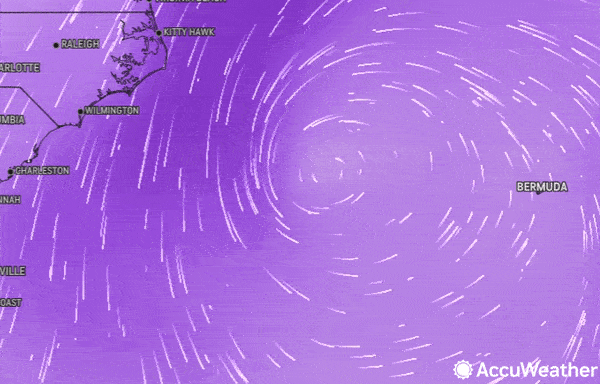
The storm is shown on AccuWeather's Wind Flow map on the morning of May 10, 2022. |
With surf temperatures being mainly 70s on the southern Atlantic coast, those considering getting a quick swim or surf in might want to think twice before taking the plunge as rip currents will likely be strong.
 |
"The rip current risk will be most dangerous along the Southeast coast," Johnson-Levine said. That being said, dangerous rip currents can be found in many places up and down the East Coast this week, but waters are still dangerously chilly for bathers along the upper mid-Atlantic and New England coasts.
Rip currents are caused by large swells that move toward coastal areas, and officials are warning swimmers and surfers to be aware of the dangers.
Later this week, the storm is forecast to bring showers and spotty thunderstorms onshore as well from southern New Jersey to northern Florida.
This rain would be mainly beneficial for the Southeast coast this week, as much of the region is experiencing moderate drought, according to the U.S. Drought Monitor. However, some areas could end up with problematic flooding. Regardless of whether a subtropical system forms, drenching rain will increase over parts of the Carolinas and Georgia late this week as the center of the storm spins onshore and humidity levels climb.
"While the storm will bring damp and dreary weather for some, it will also keep hot weather out of the area," said Johnson-Levine. While the interior Northeast experiences skyrocketing temperatures and summerlike weather, the mid-Atlantic and Southeast can expect more seasonable conditions due to clouds and showers.
 |
Temperatures will largely rise into the 70s by the end of the week across the Southeast. Richmond, Virginia, is forecast to have a high in the middle 70s on Friday, which is right in line with the average for this time of year. Atlanta will settle a bit lower than average with highs also in the middle 70s, compared to an average of about 80 degrees Fahrenheit. Charlotte, North Carolina, may only have temperatures rise into the lower 70s on Friday, almost 10 degrees below average.
Residents living close to the coastline will want to keep an eye on the forecast this week in case the storm develops into something more.
"Over the course of the week, there is some indication that the center of the storm will trend warmer since it will linger over warm water," said Sosnowski.
Warmer water is a key ingredient in the development of tropical systems, fueling thunderstorms as they develop tropical characteristics. A storm that develops some tropical traits but maintains some non-tropical conditions is known as a subtropical system. "While true tropical systems, such as a hurricane, are surrounded by warm and humid air, a subtropical system can contain patches of warm and humid air as well as patches of cool and dry air," Sosnowski explained.
Although the probability of this storm becoming subtropical remains low, AccuWeather forecasters say that there is still a chance it could form toward the end of the week and into the weekend.
 |
"Should the system develop a small, closed circulation with maximum sustained winds of 40 mph or greater, a subtropical depression could be declared by the National Hurricane Center," explained Sosnowski. This could occur ahead of the official start of the Atlantic hurricane season, which is June 1. The first name on the list of tropical and subtropical storms for the 2022 season is Alex.
A storm like this developing before the official start of the season is not entirely unusual, however, as there have been seven straight years of pre-season development in the Atlantic Ocean. Last year's early development occurred when Tropical Storm Ana formed on May 22, 2021.
AccuWeather's team of tropical weather forecasters, led by Hurricane Expert Dan Kottlowski, predicted that there would be a high chance for a pre-season storm in its 2022 Atlantic hurricane season forecast which was released in late March.
Track these severe weather conditions and more with the AccuWeather app. For next-level safety, unlock AccuWeather Alerts™ with Premium+. These advanced, hyperlocal notifications are prompted by our expert meteorologists and are often delivered much further ahead of government warnings when possible.