Despite busy storm track, snow may remain scarce in big cities along East Coast


The Interstate-95 corridor saw a few fleeting chances for snowfall, and even a stray flake or two during November, but nothing measurable, and it seems December will continue in the same manner. However, AccuWeather meteorologists say there will be a busy storm track that could drop more snow across interior areas next week - and occasional chances for winter weather farther east.
Despite a much-colder-than-average weather pattern with Alberta clipper storms thrown in during recent days, most of the coastal Northeast has managed to avoid accumulating snow thus far this season. The clippers have managed to produce spotty trace amounts of snow, due to snow showers in some cases. One such clipper storm attempted to do just that Tuesday.
Additional clipper storms will follow through the end of the week, but indications are that these will track progressively farther north and the chances for snow will retreat northward as well over time as the jet stream withdrawals toward Canada.
A somewhat bigger burst of cold air, compared to the cold shots that will precede it, is forecast to plunge southward from Canada into the Northeast states in the wake of a clipper storm Friday.
 |
That cold blast will set a pattern change into motion later this weekend and early next week that may provide the setup for a winter storm to evolve. AccuWeather forecasters are analyzing multiple scenarios that could play out.
"A sharp southward dip in the jet stream is expected to develop over the Great Lakes and how far south that dip occurs may determine the track of another storm," AccuWeather Chief On-Air Meteorologist Bernie Rayno said.
Should the jet stream dip toward the Ohio Valley Sunday, it might allow a storm to develop and track across the lower mid-Atlantic coast and then just south of New England.
 |
If that happens, "The best chance for significant accumulating snow would occur in the central Appalachians and perhaps in areas just to the north and west of I-95 in the upper mid-Atlantic and New England regions from Sunday to Monday," AccuWeather Senior Meteorologist Bob Smerbeck explained.
Drenching rain or a period of rain would still likely occur along the coast.
If the jet stream does not dip as far to the south, then the storm will likely take a track farther to the north and, therefore, prevent or significantly limit snow along the I-95 corridor.
"With a shallow dip in the jet stream, any accumulating snow might be restricted to areas in northern New York state and northwestern New England," Smerbeck said. Areas farther to the south may experience rain showers, some of which could transition to snow showers, as a cold front associated with the storm swings through from Sunday to Monday, he added.
 |
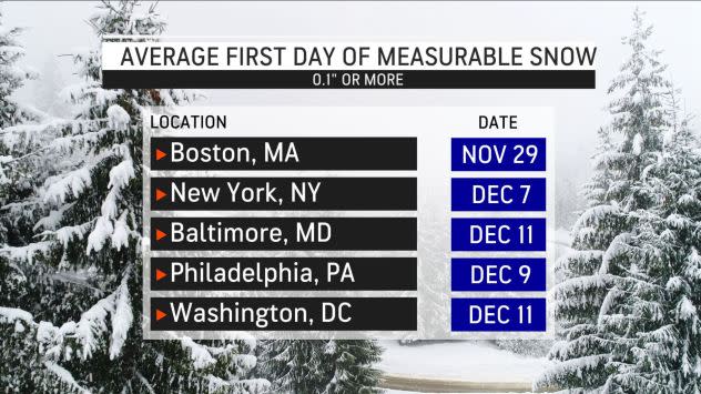
For anyone who may be wondering what's taking so long for the first measurable snowfall to materialize, is important to note that the average first date of measurable snow for much of the major cities from the nation's capital northward along the East Coast is not until mid-December.
CLICK HERE FOR THE FREE ACCUWEATHER APP
Boston is the primary outlier with an average first measurable snowfall, 0.1 of an inch of accumulation or more, date of Nov. 29. Otherwise, New York City and Baltimore typically pick up the measurable snow on Dec. 7 and 11, while Philadelphia typically sees it on Dec. 9. In Washington, D.C., the average first measurable snowfall date is Dec. 11.
 |
The main reason snowfall in many coastal areas of the I-95 corridor comes well into December rather than sooner is the temperatures of the Atlantic Ocean waters at this time of the year. Because water loses heat much more slowly than the air and the land, it is able to stay relatively warm, even when below-freezing air blows across it for an extended period of time.
Atlantic Ocean water temperatures early this week ranged from the upper 40s F off the eastern coast of New England to the mid-50s off much of the mid-Atlantic coast, readings that are several degrees higher than average.
Another factor that can limit the chances for East Coast snow, or even a major snowfall for a large part of the interior, is the speed with which weather systems move from west to east.
"A lack of atmospheric blocking will keep storm systems moving along and prevent cold air for lingering very long in their wake this weekend to early next week and for many days beyond," AccuWeather Senior Meteorologist Brett Anderson said.
 |
This snowfall analysis from the Office of Water Prediction from the National Oceanic and Atmospheric Administration shows up to a foot of snow on the ground over parts of the interior Northeast which is due largely to lake-effect events thus far. (NOAA) |
Atmospheric blocking, essentially a traffic jam in the atmosphere, can cause storms to slow down and strengthen and also keep cold air in place for enough time to allow a substantial amount of snow, or snow and ice, to occur should a storm come along. This will have an influence over whatever scenario ends up developing early next week.
"Cold air is unlikely to stick around long enough to allow a big accumulation of snow along I-95," Anderson said. He pointed out that there might be just enough cold air at the very start of the storm for a wintry mix to develop along I-95 from New York City up through the Northeast before rain would take over.
In order for a big snowfall in the coastal Northeast, the cold air would have to be locked in for an extended period or for the storm to strengthen while reaching the mid-Atlantic coast and cause cold air to be drawn in.
"Nothing is really showing that at this point, but this far out things can change," Smerbeck said.
For the latest weather news check back on AccuWeather.com. Watch the AccuWeather Network on DIRECTV, Frontier, Spectrum, fuboTV, Philo, and Verizon Fios. AccuWeather Now is now available on your preferred streaming platform.
The warm waters along the Northeast coast can be a starting point for strong storms and major impact in the Northeast, but only if the weather pattern allows them to linger long enough.
Should the storm from Sunday to Monday miss its opportunity to produce snow in the coastal Northeast, a trailing feature may succeed with a chance of fresh cold in place by Tuesday and Wednesday.
AccuWeather will continue to provide updates on the storm potential and any significant snowfall risk in the coming days.
Correction: A previous version of this story misstated the dates for the average first measurable snowfall for New York City, Baltimore, Philadelphia, and Washington D.C.
