‘Storm train' packing gusty winds to soak Northwest through early November


After an extended break from rain and snow for the better part of the last week, the Pacific Northwest will continue to be socked by a series of storms packing significant bouts of precipitation and strong winds through the first week of November, AccuWeather meteorologists warn.
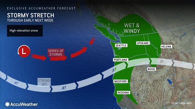
This stormy setup, which typically occurs heading into and during the winter months, is often called a storm train because weather systems arrive like cars in a freight train with a furious and steady succession for at least a week. That looks to be the case through the weekend and into next week.
 |
Because the storms will be flush with moisture from the Pacific Ocean, at least several inches of rain are in the forecast, starting with the first storm that arrived on Wednesday. An atmospheric river, which is a long plume of moisture that originates from the tropics to the subtropics or mid-latitudes, will set up. This weather phenomenon can lead to torrential rainfall and flooding in extreme cases.
"The atmospheric river will stretch all the way from the Philippines to coastal areas in Washington and Oregon into Thursday and may then return by this weekend," AccuWeather Senior Meteorologist Brett Anderson said.
Strong wind gusts that can lead to wind damage will also be possible with each storm, especially near the coast.
"An active jet stream will bring this parade of storms to the Northwest as we start November," said AccuWeather Senior Meteorologist Heather Zehr.
 |
The next storm in the 'storm train' expected to impact the Pacific Northwest of the U.S., as seen on AccuWeather RealVue™ Enhanced Satellite offshore of southwestern Canada and the West Coast as of early Friday morning, Nov. 3, 2023. |
The jet stream is a fast-moving river of air, located at the level in the atmosphere where jets cruise, that often steers storms and separates cold and warm air masses. Over the last several days dating back to last week, the jet stream was well north of the Pacific Northwest, promoting warm and dry conditions while storms came ashore in western Canada. As it sinks to the south and settles over the region for the next week, prolonged storminess will return.
The initial storm arrived on Wednesday along the Pacific Northwest coast and continued to produce downpours in the area with rain spreading well inland. The storm continued in the region on Thursday.
As of late Thursday night, 2.18 inches of rain has fallen on Astoria, Oregon, with 3.48 inches drenching Quillayute, Washington, from the storms so far this week. Seattle-Tacoma International Airport had picked up 1.25 inches.
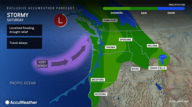
Winds gusted to as high as 62 mph at Hoquiam, Washington. That can also be the case in Hoquiam and other coastal areas with the next storm expected to move through over the weekend, which can bring similar rainfall amounts.
The next storm could wash away some outdoor weekend plans with the first raindrops arriving late Friday night or Saturday morning, with waves of heavier rain likely to bring localized flooding. This next storm will follow a bit of a break during much of the day Friday.
 |
Damp and dreary weather is likely to linger into Sunday which could once again bog down outdoor activities. Motorists should allow for extra time and take it slow due to the expectation that water will pond on highways in the most heavily-traveled locations.
While the storm earlier last week in the Northwest brought accumulating snow to most of the Cascades, that will not be the case this time. Warmer air accompanying the Pacific moisture should restrict any snow to above pass levels in these mountains in Washington and Oregon.
"This storm train will bring mostly rainy weather with high snow levels as they follow one after the other through the weekend," added Zehr.
 |
Snowfall levels, however, are expected to be lower in the Rockies as moisture from the storms arrives there a day or so after the Northwest. This means that the best chance of accumulating snow from these storms will occur in the higher terrain in Idaho, Montana and Wyoming.
After the storms this week and this weekend, the pattern will remain active across the Northwest through at least the first half of next week. While the timing and exact locations of heaviest rain are yet to be determined, residents and visitors alike should plan for at least a bout or two of rain every few days in the new week, as moisture continues to be flung ashore.
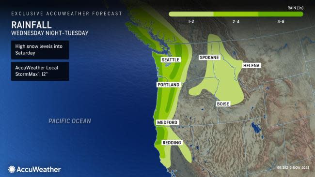
Total rainfall from multiple storms through next Tuesday will average 4-8 inches on the west-facing slopes of the Olympics, Cascades and Coast Ranges with an AccuWeather Local StormMax™ of 12 inches. Each successive storm will bring an increasing potential for flash flooding, mudslides and other debris flows as the ground in more areas becomes saturated and runoff increases.
Want next-level safety, ad-free? Unlock advanced, hyperlocal severe weather alerts when you subscribe to Premium+ on the AccuWeather app. AccuWeather Alerts™ are prompted by our expert meteorologists who monitor and analyze dangerous weather risks 24/7 to keep you and your family safer.
