Eastern US travel to be slammed by storm with heavy rain, flooding and gusty winds into Friday night
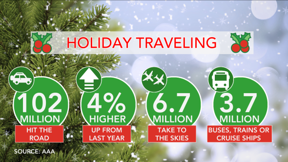
A storm packing mostly rain but also flooding, gusty winds, severe thunderstorms and some snow will hit travel hard at a time when millions are beginning their Christmas journey to end this week.
The storm will gain strength as it travels northeastward from the upper Gulf coast to eastern Quebec.
Since the storm will take a path well inland, snow and ice with the storm will be limited to the northern tier of the Northeast and on its back side over part of the Midwest.
However, the combination of drenching rain, gusty winds and poor visibility from fog and low clouds is likely to cause substantial airline delays, especially from Orlando, Florida, and Charlotte, North Carolina, to Washington, D.C., Baltimore, Philadelphia, New York City, Boston and Newark, New Jersey.
Motorists will face difficulties, especially on the highways as rain, wind and urban flooding impede their travels.
Download the free AccuWeather app to see what weather may affect your holiday travels.
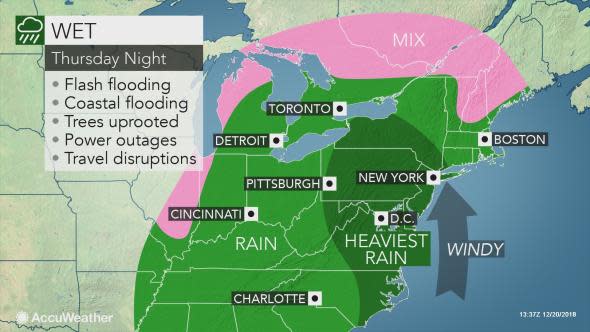
Enough rain to fall to trigger, renew flooding
"The most widespread problem from this storm will be related to drenching rain," according to AccuWeather Senior Meteorologist Brett Anderson.
"Enough rain may fall to not only cause urban and poor drainage area flooding, but also lead to small stream flooding and new rises on some of the major rivers from Florida to New England as an atmospheric river sets up for a time," Anderson said.

A swath of intense rain will shift to eastern Virginia, eastern Maryland, southeastern Pennsylvania, New Jersey, southeastern New York and New England into Friday.
There is the potential for rainfall at the rate of 1-2 inches per hour in this zone for a brief time, which is more than enough to cause water to build up on the traveling lanes and beneath the underpasses.
Coastal flooding is anticipated with this storm
The combination of stiff, onshore winds from the storm and high astronomical tides are likely to cause coastal flooding. The full moon is on Saturday, but the days leading up to the full moon result in progressively higher astronomical tides.
"The flooding will be greatest at times of high tide," Anderson said.
"Minor beach erosion is likely, even though the storm will be of short duration."
The coastal flooding risk will extend along the Carolina coast into Thursday night. During Thursday night and Friday, this risk will extend northward to the mid-Atlantic and southern New England coasts. On Friday, coastal flooding may occur along the Florida Panhandle's west coast.
Gusty winds may trigger power outages
The strengthening storm will cause winds to kick up.
The strong winds and heavy rain on the front and back sides of the storm will not only make walking and driving difficult but may also be potent enough to knock over trees and cause tree limbs to break. The soil is saturated. Trees with a poor root system may topple over in these conditions.
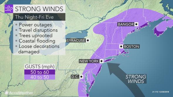
When limbs or whole trees come down, power lines may be taken with them. At the very least, expect sporadic power outages with this storm.
Winds may be the strongest and power outages the most concentrated in parts of New England, Florida and on the back side of the storm over the central and southern Appalachians.
A wintry mix and even a narrow swath of wet snow is anticipated to accompany the gusty winds on the back side of the storm on Friday and Friday night. The snow will streak from parts of the Ohio Valley and Lower Michigan to the western slopes of the Appalachians from West Virginia to western New York.

In addition, locally severe thunderstorms and isolated tornadoes are also a concern from the storm. The greatest risk of thunderstorms with strong wind gusts will be over the Florida Peninsula into Thursday night.
Blustery conditions are expected to subside from south to north during Saturday and Saturday night in the East, and dry conditions should return by Saturday night and Sunday.

Test your weather prediction skills by clicking the image above and playing Forecaster Challenge.
