New storm to unload more snow for both Midwest and Northeast

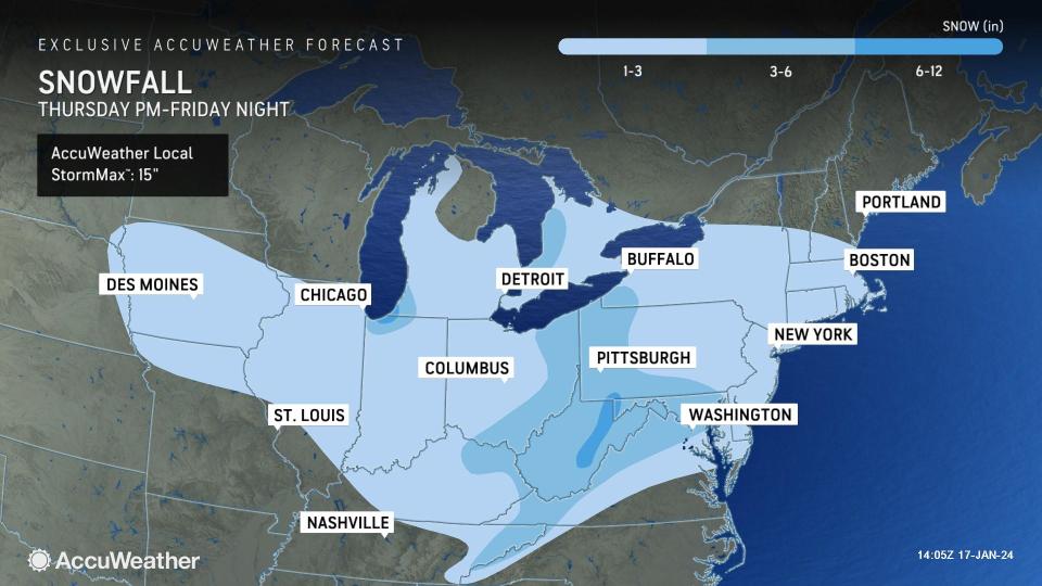
A storm hitting the Northwest with snow, ice and rain into midweek will race across the nation and is set to deliver accumulating snow from Chicago, St. Louis and Nashville to Washington, D.C., New York City and Boston prior to the end of the week, AccuWeather meteorologists say. The new storm can potentially bring several inches of snow to some locations along the way.
 |
The low temperatures over much of the Midwest and the interior Northeast will cause the snow to accumulate rather than melt on most roads. Around Chicago, while temperatures will climb above zero F, reaching the upper teens Wednesday and approaching 20 degrees Thursday, temperatures will trend downward once again during the storm and in its wake.
A storm from Monday night to Tuesday recently snapped a two-year-long snow drought in the Interstate 95 mid-Atlantic corridor, where there failed to be an inch of snow from a single storm. Early this week, a storm brought 2-5 inches of snow to the I-95 cities in the region. A separate storm from Friday to Saturday dumped 6-12 inches of snow on the Chicago area and was easily the biggest storm in two years.
 |
Even in urban areas where there is some melting of the snow, plunging temperatures following the storm will lead to freeze-ups and icy conditions. In New York City, temperatures are forecast to recover to near 32 Thursday afternoon and remain within a few degrees of the freezing mark into Friday afternoon before temperatures crash Friday night.
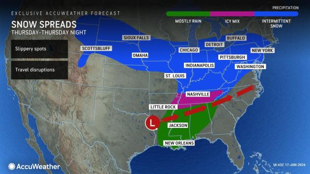
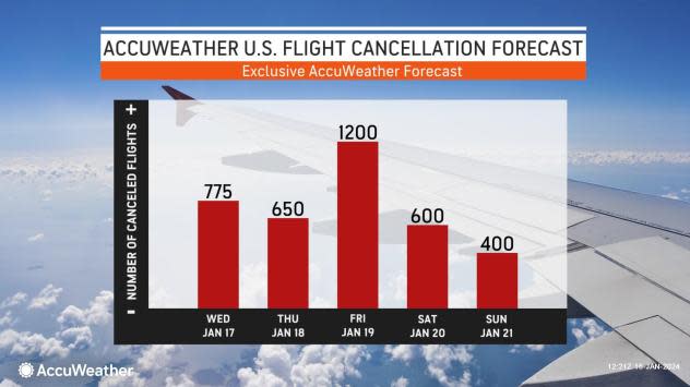
Travelers along hundreds of miles of interstates 64, 70, 80, 90 and others can expect a new round of trouble as a double-pronged storm zips from west to east across the central and eastern United States, spanning Thursday and Friday. The storm will trigger deicing operations as the snow spreads across the major airport hubs and the smaller regional airports. Flight cancellations will mount as airlines fall behind schedule and crews and aircraft are displaced.
 |
The storm will actually have two parts to it, said AccuWeather Chief On-Air Meteorologist Bernie Rayno.
"The first part will be rather weak and strung out and will tend to produce intermittent light snow and flurries," Rayno explained.
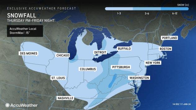
This first part of the storm will affect the Midwest Thursday and the areas farther to the east Thursday night with a coating to perhaps an inch or two of accumulation. However, the second part of the storm will tend to be a bit stronger and have more moisture to work with, affecting the Midwest from Thursday night to Friday and areas in the Northeast from Friday to Friday night.
 |
"The second storm will spread a broad zone of light snow with 1-3 inches of accumulation, but there will be pockets where 3-6 inches of snow may fall," Rayno said.
Exactly where these pockets of moderate to heavy snow develop will depend on the storm's track. A maximum of snow will most likely occur in parts of the central Appalachians. However, pockets of heavier snow may also occur in parts of the Midwest and the mid-Atlantic to southern New England.
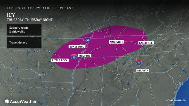
An icy zone will extend south of the snow area from central and northern Arkansas to much of Tennessee and into southern Kentucky.
 |
Regardless of the amount of sleet versus freezing rain, roads and sidewalks will be slippery from Little Rock, Arkansas, to Memphis and Knoxville, Tennessee. Nashville is likely to experience a variety of frozen or freezing precipitation.
Much of this swath recently picked up several inches of snow, with 7.6 inches burying Nashville, 3.4 inches blanketing Memphis and 3 inches covering Little Rock.
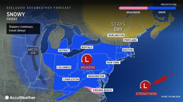
Because of a wedge of milder air, there will likely be a zone of wintry mix or rain for a time around Delmarva to southern New Jersey. However, that mild period may be brief, and accumulating snow may occur during the last part of the storm system Friday or Friday evening.
 |
It is possible that the entire storm will shift a bit farther to the south, especially in the Northeast. If this occurs, little to no snow may fall on upstate New York and much of New England and more snow would tend to fall on Virginia and the Delmarva, as colder air would be more entrenched in the region.
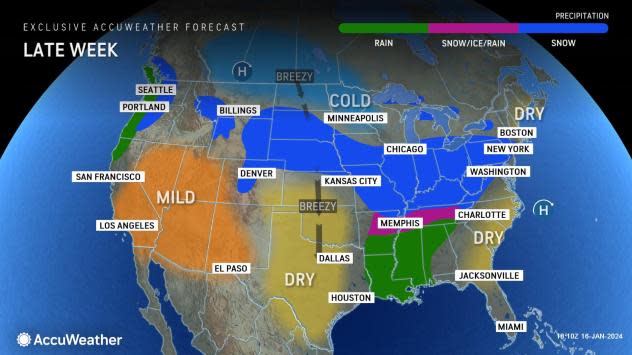
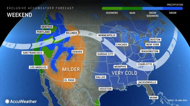
Some of the coldest air of the winter so far will settle into the Eastern states this weekend in the wake of the storm. As the cold air flows over the Great Lakes, a new round of heavy lake-effect snow will ramp up.
 |
Where there is fresh snow cover, the air can become downright frigid, with lows in the single digits and even below zero. However, even over the interior Southeast, where the ground is bare, temperatures may drop well into the teens as winds drop off and the sky becomes clear.
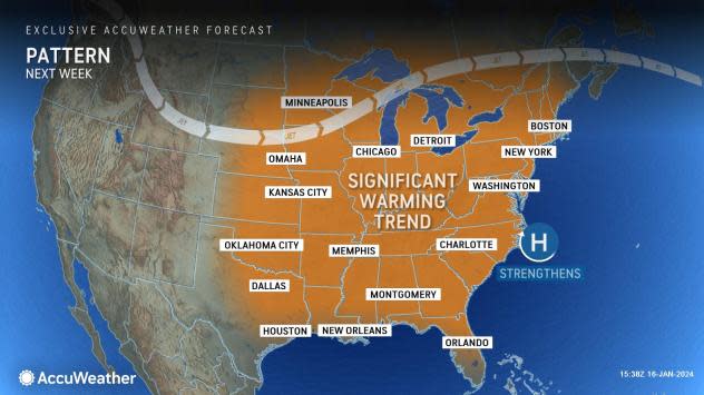
Looking ahead, after some struggles with cold nights to start off next week, temperatures are likely to rebound substantially over the Midwest and East.
 |
A storm track toward the Great Lakes is likely to resume, which would tend to push most areas onto the warmer side of the storms, at least for most of the time. There will likely still be some episodes of snow and ice on the front end of the storms over the northern tier.
Want next-level safety, ad-free? Unlock advanced, hyperlocal severe weather alerts when you subscribe to Premium+ on the AccuWeather app. AccuWeather Alerts™ are prompted by our expert meteorologists who monitor and analyze dangerous weather risks 24/7 to keep you and your family safer.
