Storm updates: California faces flood risks and strong gusts in latest atmospheric river
An atmospheric river has arrived in California, dropping another heavy round of Valley rain and mountain snow Tuesday, with flooding and very gusty winds among the main disruptors.
The National Weather Service has a flood watch in place for most of Northern California through Wednesday morning, as well as a high wind warning on Tuesday for the Sacramento Valley, Bay Area and parts of the Sierra Nevada foothills.
The atmospheric river fueling the storm is taking aim at California after flowing northeast from the subtropics near Hawaii, according to the weather service.
Mighty gusts shook California’s capital region throughout Tuesday with the weather service as of 1:30 p.m. recording peak gusts of 60 mph near Mather Airport and at McClellan Airport.
Mudslide in Colfax prompts evacuations
Officials in Placer County issued an evacuation warning for several homes following a mudslide Tuesday afternoon in Colfax.
The mudslide happened before 5 p.m. when a hillside gave way into a home on Ben Taylor Road, according to Cal Fire’s Nevada-Yuba-Placer unit, which is in unified command of the incident with the Placer County Sheriff’s Office. Photos from firefighters showed an embankment that gave way into the back of a residence, moving dirt and debris up to 5 feet on the side of the home.
All occupants of the home were accounted for and no one was injured, firefighters said, but an additional 20 homes were evacuated as crews worked to shore up the slide.
Flooding evacuations at Sutter County mobile home park
Residents of Lovey’s Landing in northwestern Sutter County were evacuated Tuesday after sheriff’s officials said rising waters could endanger the mobile home park.
“The Sacramento River is expected to rise above the 65-foot elevation at the Colusa Bridge by 11 a.m. tomorrow (Wednesday), the historic elevation where the trailer park begins to flood,” the Sutter County Sheriff’s Office said in a social media post. “This requires the power to be shut off to the park for public safety concerns. Sheriff’s deputies began notifying residents of the trailer park last week and have been working to assist with temporary relocation efforts.”
The park sits several miles north of Meridian on the river left side of the channel.
Two rescued from North Sacramento creek
Two people were rescued Tuesday afternoon by Sacramento Fire Department personnel after finding themselves trapped inside a makeshift shelter situated on Steelhead Creek in North Sacramento.
The Fire Department said in a social media post that crews were called to Natoma Street and Tenaya Avenue in the Gardenland neighborhood after the two adults and a dog became surrounded by stormwater in the channel that separates North Sacramento from Natomas.
The social media post showed crews accessing the shanty via rescue boats as waters on Steelhead Creek rushed by. The creek, which is walled off by earthen levees, is used by fall-run Chinook salmon and steelhead trout to migrate up from the American River at Discovery Park to Dry Creek where they spawn, according to the Valley Foothill Watersheds Collaborative.
Firefighters said no one was injured.
Water Rescue, Tenaya Ave and Natoma St. Two adults and a dog were trapped inside of a makeshift shelter and had to be extricated via rescue boats. Nobody was injured. Be mindful of the rising waters and get to higher ground. pic.twitter.com/I8IvUAiH1L
— Sacramento Fire Department (@SacFirePIO) March 14, 2023
Evacuation warnings for Amador County
Potential flooding prompted evacuation warnings Tuesday morning for several parts of Amador County, sheriff’s officials said.
Warnings were put into place at 10 a.m. for parts of Jackson, Sutter Creek, Ione and nearby unincorporated areas, the Amador County Sheriff’s Office said.
Neighborhoods and streets included in the evacuation warning were available on the Sheriff’s Office’s Facebook page.
The warning remained voluntary as of 11 a.m. Residents living in those areas should be prepared to evacuate at a moment’s notice.
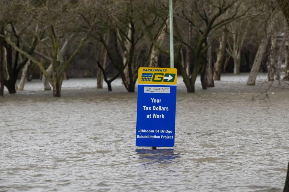
Flooding possible amid heavy rain in valley and foothills
Flood risk will be highest in low-lying parts of the Valley, including southern portions of Sacramento County along the Cosumnes River; and in parts of the foothills, where heavy rain could mix with snowmelt from recent winter storms. Localized roadway flooding, near creeks and rivers, will also be possible.
About an inch of rain could fall Tuesday in the capital city, forecasts show.
Up to 2 inches are possible in other parts of the Sacramento and San Joaquin valleys, according to the weather service.
In unincorporated Sacramento County, five sandbag locations are open to residents: at 3847 Branch Center Road; at the Orangevale Community Center (6826 Hazel Ave.); at Westside Park (6555 West Second Street); at the Wilton Fire Station (10661 Alta Mesa Road); and at Point Pleasant United Methodist Church (3329 Point Pleasant Road).
Periods of moderate to heavy rain will continue this morning, leading to areas of nuisance flooding. Be prepared for a wet morning commute throughout Valley. If you encounter flooded roadways, remember: turn around, don't drown! #CAwx pic.twitter.com/d7wogxXMVV
— NWS Sacramento (@NWSSacramento) March 14, 2023
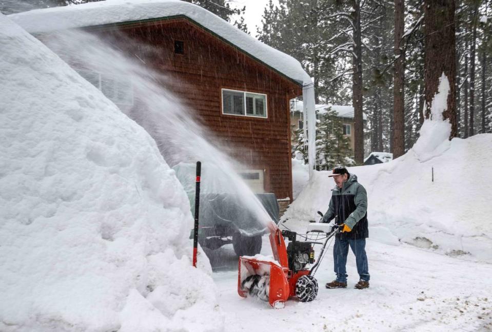
Another strong round of snow
The current atmospheric river system is bringing yet another significant winter storm to the Sierra Nevada mountains.
Forecasts showed 1 to 3 feet of fresh snow likely above elevations of 6,500 feet between Monday and Wednesday, with feet or more possible above 8,000 feet, according to the weather service.
Major delays and potential whiteout conditions are anticipated on mountain highways.
California’s snow totals this winter are already on the brink of all-time records. State water data as of Monday showed California at 215% of its average snowpack for the date, including 223% of normal in the central Sierra and 257% of normal in the southern Sierra.
Very strong winds across California
Gusts near Sacramento could approach 50 mph on Tuesday, forecasters said.
Gusts could reach 60 mph in other parts of the valley and 70 mph in the mountains, according to the weather service.
Winds that strong could knock out power, in addition to toppling trees or tree limbs and making driving conditions hazardous.
The Sacramento Municipal Utility District and Pacific Gas and Electric Co. urged residents to be prepared for power outages.
About 20,000 homes and businesses in Sacramento County lost power Tuesday morning, according to SMUD’s online outage map, including more than 15,800 without power in the Rio Linda area and nearly 1,400 in Rosemont just after 11:30 a.m.
Outages in PG&E territory include: nearly 1,400 customers in El Dorado County and over 600 homes and businesses in Amador County.
Strong, damaging winds are still on track! Here is a look at the forecast timing of the winds. Gusty winds will pick up this morning and continue through the evening. Expect wind gusts 50-60 mph in the Valley, with gusts up to 70 mph over the mountains. #cawx pic.twitter.com/jH8qP3k3SX
— NWS Sacramento (@NWSSacramento) March 14, 2023
State, local officials still responding to last week’s storms
An atmospheric river storm late last week produced flooding in parts of the San Joaquin Valley and along the central coast, with both regions vulnerable in this week’s storm.
In the Monterey County town of Pajaro, a levee on the Pajaro River broke Saturday morning, shortly after residents and flood control crews evacuated the area. State officials have authorized funding for emergency repair work on the levee.
Gov. Gavin Newsom on Sunday expanded an emergency proclamation for the storms to include Calaveras, Del Norte, Glenn, Kings, San Benito and San Joaquin counties.
With those additions, 40 of California’s 58 counties are now under emergency proclamations by Newsom in response to severe weather. Many counties, including Sacramento, El Dorado and Placer, have also issued their own local emergency declarations.
President Joe Biden last week issued a presidential emergency declaration, authorizing federal aid for state and local storm response, following a request from the Newsom administration.
More storms may be on the way
After the storm clears out around midweek, more wet weather is expected by the weekend.
State water officials in a Monday briefing said one to two more atmospheric rivers could strike the state between this coming Sunday and the middle of next week, with the magnitude and exact timing of those potential storms still uncertain.
“We’re not done yet,” Michael Anderson, the state’s climatologist, said in a virtual Department of Water Resources briefing Monday afternoon.
The Bee’s Rosalio Ahumada contributed to this story.

