Storms to bring light rain, snow and ‘coldest air of the season’ to San Diego County

SAN DIEGO — San Diego County will be hit by a pair of storms this week, bringing light rain, possible low-elevation snow and “some of the coldest air of the season.”
According to the National Weather Service, San Diego will see the initial impacts of the first storm Wednesday morning after a brief warm-up on Tuesday.
Forecasters say a cold trough deepening over Southern California will push a cold front from northwest to southeast throughout the day. During that time, showers and gusty winds are expected to accompany the front as it moves.
VIDEO: Boat nearly capsizes in Mission Bay as massive waves roar
With the first storm, precipitation is expected to break out in the morning before intensifying midday. This bring snow levels down to near 5,000 to 5,500 feet. Elevations above 5,500 feet could accumulate several inches of snow, NWS says.
This means snow could be possible in areas like Cuyamaca Peak and Palomar Mountain. A winter weather advisory has been issued for the region’s northernmost mountains from 10 a.m. to 8 p.m. Wednesday.
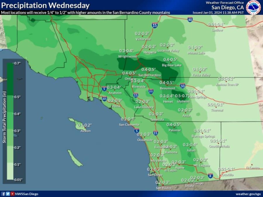
Predicted rainfall totals west of the mountains range from 0.20 inches to 0.40 inches, while communities in the mountains are likely to see anywhere from 0.25 to an inch. Desert areas could see around 0.10 to 0.25 inches, according to NWS.
Gusty wind moving from south to west is also expected to sweep through the area as the front passes, followed by colder air.
A wind advisory was issued by NWS for San Diego County’s mountains from 10 a.m. Wednesday to 4 p.m. Residents should exercise caution when driving through these areas, as well as secure any loose objects that could be blown around.
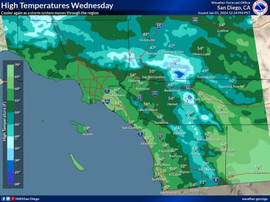
High temperatures will be in the upper 30s to mid 40s in mountain areas Wednesday, according to NWS. Outside mountain areas, highs will hover around the upper 50s and low 60s for much of the county.
This first system is expected to move through the region quickly, but forecasters say it should have good upper-level jet support. Although, there may be just enough instability with the system to trigger a few thunderstorms, according to NWS.
Scattered showers will likely linger behind the front into Thursday morning before cooler, dry weather will briefly set in. By Saturday, another cold wave in the Polar Jet will start to make its way south from Canada, bringing with it additional possible rainfall and snow.
“This one has a good amount of cold air backed up behind it, supporting a strong northerly jet with momentum to carry it through Southern California,” forecasters said on Monday. “This one is still quite a few days out, so determining the impact now is dubious.”
However, initial models from NWS project that this storm will bring some of the “coldest air of the season” thus far, dropping snow levels to about 3,500 to 4,000 feet.
Photos: High surf impacts San Diego coastline
The track of the storm positions it to have a little less moisture availability than the first, but the instability combined with the air could sustain periods of light precipitation. For lower-elevation mountain areas in San Diego County like Julian and Pine Valley, this means the storm could bring some snow showers.
According to NWS, both storms this week are expected to bring more high surf and strong rip currents late Wednesday into Thursday, with sets up to 10 feet possible on exposed west-facing beaches. An high surf advisory advisory has been issued for the county.
Looking forward, NWS says not to expect warm weather to return anytime soon: a cold wave moving up from the Arctic is on the horizon for the region.
“Looks like the seasonal forecast outlooks have caught on now, with the latest (Climate Prediction Center) monthly outlook for January indicating likely below normal temperatures for SoCal,” forecasters said.
For the latest news, weather, sports, and streaming video, head to FOX 5 San Diego.


