Storms combining forces will bring slippery snow to Rockies, High Plains over Christmas weekend


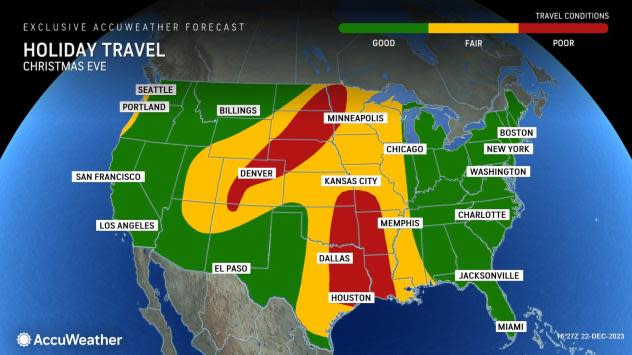
The trip over the river and through the woods will be a snowy one this Christmas weekend from the Rocky Mountain states into the High Plains, as a pair of storms join up over the region, AccuWeather meteorologists say.
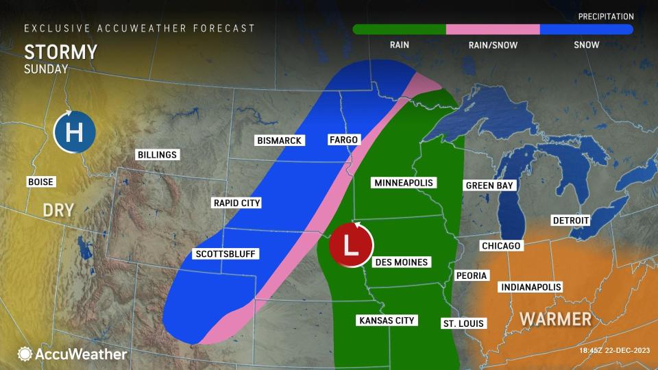
The new storm, combining forces from storms bringing heavy rain and flooding to Southern California and the Southwest deserts and rain and snow showers to the Pacific Northwest late this week, will all but guarantee a white Christmas in a swath from Arizona to the Dakotas. This will be in stark contrast to much of the rest of the country, which will be snow-free for the holiday.
"Santa seems to have decided the people in the Rockies and High Plains will be on the nice list and will get a white Christmas this year," AccuWeather Senior Meteorologist Tyler Roys said. While snow lovers may enjoy the picturesque, snowy landscapes come Christmas morning, the timing and amounts of snow expected will not be ideal for travel in the region starting Saturday.
 |
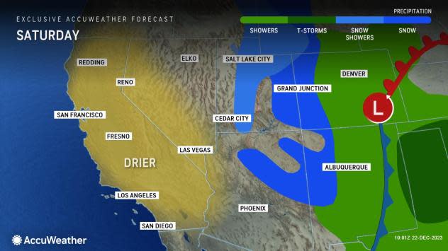
The Four Corners region, encompassing portions of Arizona, Colorado, New Mexico and Utah, were the first to see snow as the storm from California arrived. The precipitation began as a period of rain in many areas before the cold air rushed in, including in Flagstaff, Arizona, before transitioning to a coating to an inch of snow through Saturday.
For Flagstaff, this will be only the second snow event of the season thus far. The city is well behind the historical average for snow through Dec. 20, with 4.8 inches observed versus the historical average of 20.9 inches. It does not appear that the deficit will be closed with this storm, but there may still be enough snow to cause some slush on roads through the weekend.
 |
As the southern storm joins forces with the one coming from the Pacific Northwest through Saturday night, the footprint of the unsettled weather will dramatically increase in size. Colorado Springs, Denver and Salt Lake City will be among the larger cities that will see flakes flying for the first half of the weekend, following a brief period of rain.
Accumulations should be light in Salt Lake City-likely less than an inch- with snow falling at a heavier rate and for a longer amount of time farther east. Heftier accumulations are expected across Colorado, much of Wyoming and across the High Plains.
 |
"In typical Denver fashion, this is going to be a case of people going to bed [on Saturday] with little snow and temperatures above freezing, and then waking up [on Sunday] to several inches of snow the next day," Roys explained.
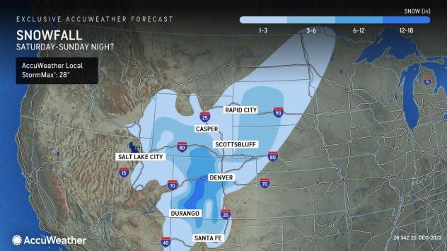
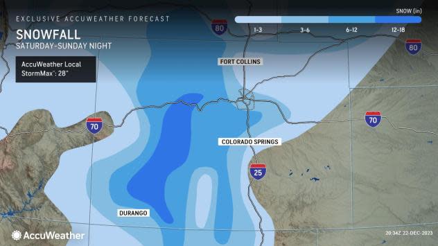
Across the Denver metropolitan area, AccuWeather is expecting 2-4 inches of snow, with the prospects of some locally higher amounts, especially in the nearby mountains to the west and the higher ground of the Palmer Divide to the south.
 |
As is usually the case with winter storms in the Rockies, the "jackpot zone" of highest totals should be in the Rocky Mountains of Colorado, where amounts in the 6- to 18-inch range will be common, with an AccuWeather Local StormMax™ of 28 inches. Because of this, travel over the mountain passes will be extremely treacherous and should only be attempted with the appropriate chains on tires.
 |
Among the airports in the region that can be impacted by the storm, Denver International will be the most susceptible to flight delays and cancellations, according to Roys. This could end up being consequential at other, faraway airports across the nation from late Saturday through Sunday since Denver is a major air hub.
Trips to the north from Denver along Interstate 25 through Cheyenne and Casper, Wyoming, then east along interstates 76, 80 and 90 to North Platte, Nebraska, and Rapid City, South Dakota, will also be treacherous as the storm moves through on Sunday, as several inches of snow can also fall in these areas.
 |
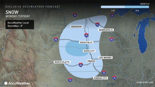
AccuWeather meteorologists will continue to monitor the storm as it advances eastward into the Plains and Upper Midwest, where, at the last minute, it could make the wish of a white Christmas come true. The latest projections call for several inches of snow to accumulate from northern Kansas to Minnesota into Tuesday, and the snow can be accompanied by gusty winds that make for treacherous travel.
 |
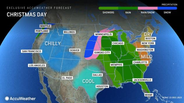
Meanwhile, southward across most of the central and southern Plains and into the Mississippi Valley and South, a soaking rain may lead to localized flooding on Christmas Eve and Day.
Santa's gift of snow may be short-lived, however, as a period of milder weather accompanied by sunshine can melt the snow in many areas as soon as the days following Christmas. In Denver, the AccuWeather forecast calls for the temperatures to approach the 50s as early as Thursday.
Want next-level safety, ad-free? Unlock advanced, hyperlocal severe weather alerts when you subscribe to Premium+ on the AccuWeather app. AccuWeather Alerts™ are prompted by our expert meteorologists who monitor and analyze dangerous weather risks 24/7 to keep you and your family safer.
