Flooding vulnerabilities of L.A. River's Glendale Narrows spark concern amid record rain
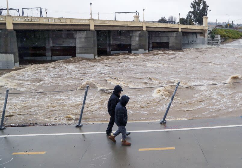
Heavy rain this week turned the Los Angeles River flood-control channel into a raging torrent, and with new storms expected on Monday, emergency officials are keeping a wary eye on a well-known stretch that has long been vulnerable to flooding.
Glendale Narrows is a lush seven-mile section of rumbling runoff between Griffith Park and downtown that attracts numerous sightseers and bicyclists. But despite its Instagram appeal, the narrows is a flood manager's nightmare.
It remains one of the few areas along the World War II-era channel that has a soft bottom due to its high water table. As a result, it is prone to erosion and buildups of sediment, vegetation and debris that could back up flows dumped by major storms.
It is also the only major segment of the 51-mile-long L.A. River flood-control system that was not designed to contain a 100-year flood, or a major deluge that has a 1% chance of occurring in any given year.
To make matters worse, this stretch of river is frequently crowded with weeds and trees.
“Glendale Narrows is a choke point that we watch closely,” said Mark Pestrella, director and chief engineer of the Los Angeles County Flood Control District. “The big problem is that it is under the control of Army Corps [of Engineers}, which is not adequately funded to clean out the area on a regular basis.”
Although it is "armored" with flood barriers installed by the Army Corps to protect surrounding neighborhoods, industrial areas and freeways, major downpours still spark concern among county flood managers.
County officials have proposed taking ownership of 40 miles of flood-control channels still operated by the federal government. By doing so, they hope to expedite maintenance and improvements as climate change increases the frequency of extreme weather.
Such a transfer of authority, however, would require congressional approval. “That could happen very soon,” Pestrella said, “or not for years and years.”
The Army Corps of Engineers has helped reduce the flood risk by removing about 45,000 cubic yards of sediment from the Glendale Narrows area over the last five years, federal officials say.
In the meantime, Pestrella said, his agency routinely compensates for hydraulic deficiencies in the area by “restraining flows” of stormwater released from the county's Big Tujunga and Pacoima dams perched in the southern flanks of the San Gabriel Mountains.
Frequent catastrophic floods prompted civic leaders in the 1930s to transform the L.A. River into a complex flood-control channel and levee system to protect the burgeoning flatlands.
But new research suggests that the system’s channels and levees were based on 20th century assumptions that did not take into account recent “whiplashing shifts” in extreme weather caused by global warming.
In the last decade alone, California has been hit with back-to-back cycles of historic drought followed by historic rain, snow and flooding.
“I’m personally concerned about this because our levee systems are very, very old and basically made out of soil,” said Amir AghaKouchak, a UC Irvine professor. AghaKouchak co-authored a 2020 study on the impacts of climate change on levees protecting critical infrastructure–transmission lines, roads, railroads, natural gas and petroleum pipelines in densely populated areas such as Southern California’s coastal communities.
“The impacts of increasingly extreme drought ending with extreme rainfall is something that engineers who designed L.A. County's flood-control systems 80 years ago never considered,” he said.
The Department of Public Works is completing a report requested by the Los Angeles County Board of Supervisors on the viability of existing flood-control infrastructure, as well as plans for reducing flood risks and making disadvantaged communities more resilient.
The report was prompted by a recent study led by UC Irvine researchers showing how weather extremes due to climate change may affect the region, whose development was guided by social and racial divisions that favored white residents.
Communities at highest risk include Carson, Compton, Bell Gardens, South Gate, North Long Beach and portions of downtown Long Beach, including the southern end of Pine Street near the Long Beach Convention Center.
A victim of geography and explosive growth, 20-mile-long Compton Creek has for centuries drained a 42-square-mile watershed. By the 1920s, however, residents were pleading for protection from floods that inundated businesses.
Today, the upper stretch of the creek is a concrete-lined flood-control channel that cuts through Compton, carrying water to the Los Angeles River and the Pacific Ocean at Long Beach Harbor.
The creek’s dirt-bottom section winds through some of the most densely populated and highly industrialized regions in Southern California.
Forecasts of new storms to come have focused attention on the condition of earthen embankments guarding a segment of Compton Creek near the 91 Freeway, as well as a stretch of the L.A. River farther south in Long Beach.
In 2017, the Army Corps conducted an inspection that noted several “major deficiencies” at each of those 75-year-old levee systems, which are under the control of Los Angeles County.
At the Compton segment, it found trees with trunks larger than 2 inches in diameter, depressions on the levee crown measuring up to 8 inches deep, an unpermitted 15-inch petroleum pipeline penetrating the top of the riverward slope, and, it said, “vines completely covering the majority of the flood wall preventing inspection.”
Problems at the Los Angeles River segment included erosion gullies up to 30 inches deep, several 16-inch-diameter pressurized gas pipelines penetrating the toe of the riverward slope, and an unpermitted 12-inch-diameter steel pipe on the levee crown.
Army Corps levee safety officers rated the systems to be “minimally acceptable” after determining that the deficiencies would not prevent them from performing as intended during the next significant runoff event.
The county, however, has still not submitted documentation showing that the deficiencies have been corrected, which are required in order for it to be eligible to receive federal funding toward the cost of repairs, Army Corps officials said.
“We have not been provided with documentation stating that the deficiencies have been corrected," said Dena O’Dell, spokeswoman for the Army Corps, "but that is not to say that the county has not performed the work.”
The next periodic inspection of the levees will be conducted sometime next year, federal officials said.
Among the Army Corps’ top priorities in Southern California is spending roughly $600 million to upgrade 64-year-old Whittier Narrows Dam, built in a natural gap in the hills about 11 miles east of Los Angeles to impound water from the San Gabriel River and Rio Hondo.
The three-mile-long earthen dam was placed in the agency’s highest-risk category when it determined that several potential failure scenarios threatened more than 1 million people downstream, from Pico Rivera to Long Beach.
Work on improvements designed to make the dam more resilient to future storms is expected to begin in 2025 and take four years to complete, officials said.
In the meantime, a coalition led by the Federal Emergency Management Agency and local flood risk managers is gearing up to launch an unprecedented year-long public service crusade to raise awareness of flood risks across the Los Angeles River’s 824-square-mile watershed.
Coming soon will be multimedia alerts and televised announcements popping up across the region, targeting an audience that hadn’t given the threat much thought before.
“Pretty soon,” Pestrella said, “you’ll be seeing people including me on television recommending that we invest in community awareness programs, promote flood insurance, and retrofit structures where appropriate.”
“But right now, the most important message of all is this one: Whether it’s rain or shine, do not go in the river,” he said. “It is not safe.”
This story originally appeared in Los Angeles Times.

