Storms could escalate fire dangers in Southwest late this week


A rash of thunderstorms expected to form and roam the southwestern United States in the coming days that will bring lightning that could spark new wildfires, AccuWeather forecasters warn.
The storms that develop, especially in the mountains of Central and Southern California from late Wednesday through Friday, many will feature lightning but very little rainfall and are known as dry thunderstorms. This is a dangerous recipe as the region barrels into the annual wildfire season.
The threat of these dry thunderstorms will expand into parts of the Northwest by the weekend.
 |
The impetus for thunderstorms in the Southwest on Friday will be lingering energy from former Tropical Storm Eugene, which dissipated earlier this week, according to AccuWeather forecasters.
Accompanying the lingering energy from Eugene will be some moisture, which can increase the humidity across much of California and help to trigger storms, mainly across higher terrain.
"Moisture in the upper atmosphere can help to develop thunderstorms across the mountains of Southern California and the Sierra Nevada," said AccuWeather Senior Meteorologist Adam Douty. "The lack of moisture near ground level can lead to little rainfall with many of the storms."
These storms will also impact parts of Arizona, Colorado, Nevada, New Mexico and Utah. They will tend to ignite over higher elevations and with the heating of the day before diminishing at night.
The combination of little rainfall and lightning could lead to the ignition of new wildfires as the region heads into the thick of wildfire season, which typically runs from July to October.
 |
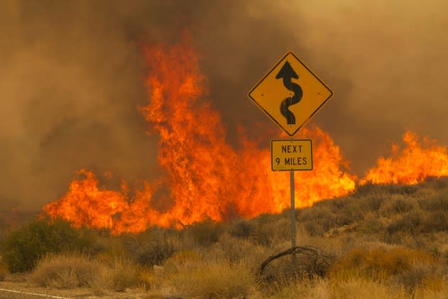
Flames rise from the York Fire on Ivanpah Rd. on Sunday, July 30, 2023, in the Mojave National Preserve, Calif. Crews battled “fire whirls” in California’s Mojave National Preserve this weekend as a massive wildfire crossed into Nevada amid dangerously high temperatures and raging winds. (AP Photo/Ty O'Neil) |
According to the California Department of Forestry and Fire Protection, there were 9 active wildfires across California as of Wednesday morning. The No Name Fire is the largest blaze that started August 5th, 2023 and has already scorched over 1,120 acres in Riverside County to the southwest of Los Angeles.
Despite nearly half a dozen active fires, this is below the historical average for August, at least compared to recent seasons. This is largely due to the record amounts of rain and snow the state recorded late last year and earlier this year. However, AccuWeather experts warn that current conditions are ripe for the development of new fires.
"We are just now getting into the thick of the dry season in California," said AccuWeather Meteorologist Joe Bauer. "The longstanding blanket of snow that has remained since last winter has vanished at many reporting stations in the Sierra."
With the loss of the snowpack at all but the highest elevations, there will be plenty of dry vegetation, or fuels that can be ignited by lightning in the mountains and nearby foothills, added Bauer.
"Gusty winds associated with thunderstorms can also lead to rapid fire growth," warned Douty.
 |
California and the Southwest will not be the only region at risk for dry storms, which can lead to new wildfires. AccuWeather forecasters warn that by this weekend, the energy and moisture associated with the threat late in the workweek will expand into more of the Northwest.
On Saturday and Sunday, thunderstorms with very little rain will also erupt in parts of the northern Sierra Nevada range in Northern California, and also over mountains as far north and east as southern Idaho and southwestern Wyoming.
 |
High pressure returning to the West Monday will largely end the threat of thunderstorms for an extended period of time. It will also fuel a massive warmup from the Central Valley of California north to the interior Pacific Northwest.
Temperatures will be as much as 15 degrees above historical averages for the early and middle part of next week, AccuWeather forecasters say. Combined with little or no rainfall, and a preexisting drought in parts of the Northwest, the uptick in temperatures can also fuel a wildfire risk.
Just enough moisture will be pumped into the region to allow some of the storms to bring localized rain that can be beneficial and problematic.
"In some cases, enough rain will fall to dampen the landscape temporarily and ease the wildfire threat," AccuWeather Senior Meteorologist Alex Sosnowski said.
For example, in Riverside, California, occasional drizzle evolved into drenching downpours that delivered 0.20 of an inch of rain early Thursday morning. Riverside only averages about 0.03 of an inch of rain the entire month of August.
However, in a few locations, too much rain may fall too fast on the dry, hard-packed landscape or in urban areas and lead to flash flooding, Sosnowski said. These will tend to be very isolated in the pattern, but there is a risk that some dry stream beds, called arroyos, can briefly become raging rivers. Street flooding is possible in some neighborhoods where downpours linger for more than a few minutes.
Motorists and hikers should be aware that storms miles upstream can bring a torrent of water even when rain may not be falling in the immediate vicinity.
Want next-level safety, ad-free? Unlock advanced, hyperlocal severe weather alerts when you subscribe to Premium+ on the AccuWeather app. AccuWeather Alerts™ are prompted by our expert meteorologists who monitor and analyze dangerous weather risks 24/7 to keep you and your family safer.
