Storms headed to Southeast Georgia, Northeast Florida, could continue overnight
- Oops!Something went wrong.Please try again later.
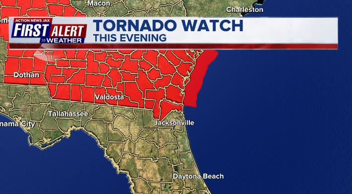
A tornado watch has been issued for portions of our area until 10 p.m. The following counties are included:
Brantley
Camden
Charlton
Glynn
Pierce
Ware
Nassau
WATCH THE FORECAST | DOWNLOAD THE APPS
The Action News Jax First Alert Weather Center is monitoring First Alert Doppler HD for developing storms in our area. Here’s what Chief Meteorologist Mike Buresh said we can expect:
The highest threat is over our Southeast Georgia viewing area through 6 to 7 p.m. Severe storms will be possible for areas like Waycross, Blackshear, Brunswick and Folkston.
Isolated storms over Northeast Florida through early evening, a few of which could be strong in spots. Buresh said the storms will be hit and miss, including Duval County/Jacksonville.
Storms increase over Jacksonville/Northeast Florida later this evening into the overnight with the potential for a severe storm as well as lots of lightning and heavy rain.
Follow Action News Jax Meteorologists on Twitter for updates:
Mike Buresh | Garrett Bedenbaugh | Corey Simma
Storms may continue through midnight and/or beyond.
This is part of an ongoing storm complex or multiple clusters of storms from Georgia through Alabama, Mississippi, Louisiana.
LISTEN: Mike Buresh ‘All the Weather, All the Time’ Podcast
Other watches could be issued this evening/overnight.
The set-up is unusually strong (stormy) for mid-June.
INTERACTIVE RADAR: Keep track of the rain as it moves through your neighborhood
SHARE WITH US: Send us photos of the weather you’re seeing in your area ⬇️

