Storms poised to drench drought-stricken areas of southern US


A pair of storms will bring much-needed rain from the Gulf Coast to near the Interstate 40 corridor of the south-central and southeastern United States into this weekend, but one of the storms also has the potential to unleash severe weather, AccuWeather meteorologists warn.
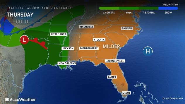
The storms will accompany a return to warmer conditions, following much colder weather earlier in the week.
 |
Rain has been gathering over the western and central parts of the Gulf of Mexico since this past Sunday, and an upcoming storm tracking in from the Southwest will pull the rain northward over the Gulf Coast states, along with clouds and milder conditions.
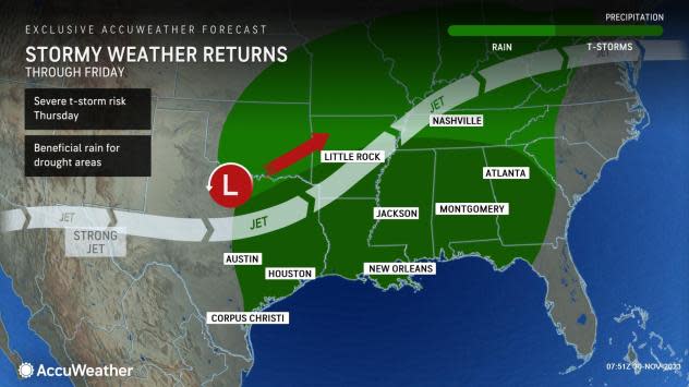
During Thursday and Friday, rain will erupt and expand from east-central Texas to Illinois, Indiana, Ohio and West Virginia, as well as parts of Florida, Georgia and the Carolinas.
 |
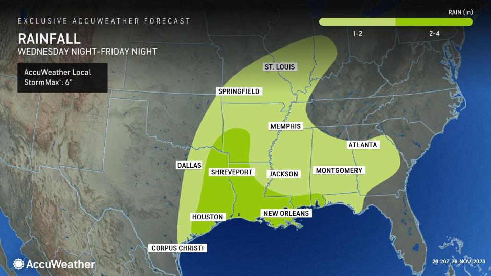
"Within this zone over the lower part of the Mississippi Valley and Delta, a general 1-2 inches of rain will fall, with the likelihood of 2-4 inches of rain and locally higher amounts in northeastern Texas, western Louisiana and southwestern Arkansas," AccuWeather Senior Meteorologist Brett Anderson said. "There is an AccuWeather Local StormMax™ of 6 inches in this enhanced rain area."
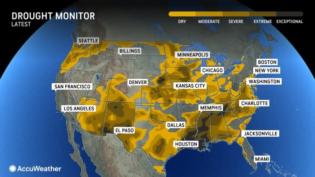
Some of the rain will fall on areas in exceptional drought, which is the most extreme level, according to the United States Drought Monitor.
While flash flooding will not be widespread with the storm, there is the potential for localized flooding where rain pours down so fast that storm drains cannot handle the runoff, AccuWeather Meteorologist Joe Bauer said.
 |
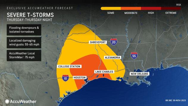
The flash flooding risk will be greatest in thunderstorms that erupt -- and some of those thunderstorms have the potential to become severe on Thursday from central Texas to Louisiana and far southwestern Mississippi. However, a significant outbreak is not expected at this time.
Should the sun emerge even briefly, it could be enough to fuel damaging thunderstorms. The risk of severe weather includes not only powerful wind gusts and flash flooding but also the potential for a few tornadoes.
 |
From Friday to Friday night, the risk of severe thunderstorms will have diminished but will not be non-existent farther to the east in portions of eastern Louisiana, Mississippi, Alabama, the Florida Panhandle and Georgia.
The same storm will spread rain and even a wintry mix across portions of the Northeast from Friday to early Saturday.
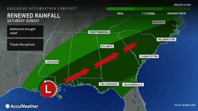
Soon after the first storm rolls out of the Southern states, a new storm will spring up over the Gulf of Mexico and harness yet another round of moisture.
The second storm will be more of a rainmaker for the Southeastern states with areas from Louisiana to North Carolina and northern Florida in the soak zone. The heaviest rain, where several inches of rain may fall, is most likely to extend from southeastern Louisiana to eastern North Carolina.
 |
Some of the rain will overlap the rain from the first storm, which will be an added bonus for drought relief and could push totals to between 4 and 8 inches in parts of the region.
New Orleans has received only 55% of its historical average rainfall since July 1, with only 14.56 inches versus the average of 26.24 inches through Nov. 29. The drought is much worse in Jackson, Mississippi, where rainfall has only been about 26% of average since the start of July. In Jackson, only 5.54 inches of rain has fallen compared to 21.23 inches through Tuesday.
 |
There has been some sporadic rainfall in the past month that has helped the drought situation slightly, but more rain is needed and the combination of the two storms should help significantly.
Because some rain will fall on the middle portions of the Mississippi watershed, there should be a slight rise in water levels of the Mississippi River on the lower end in the coming weeks. The river has been running within several feet of record low levels since the late summer.
There continue to be some signs of a storm track related to an El Niño pattern setting up heading into this winter with the two storms this week. During an El Niño, the southern branch of the jet stream tends to be active with some tropical moisture for parts of the Southern states. A storm late next week could bring additional rain to parts of the Southern states.
Want next-level safety, ad-free? Unlock advanced, hyperlocal severe weather alerts when you subscribe to Premium+ on the AccuWeather app. AccuWeather Alerts™ are prompted by our expert meteorologists who monitor and analyze dangerous weather risks 24/7 to keep you and your family safer.
