Storms pummeled a Ventura neighborhood near Foster Park. Flooding woes persist. Here's why
Months after severe winter storms, dozens of residents still can’t access a creek crossing to get to their homes on a rural road north of Ventura.
Without it, the only access for residents on Camp Chaffee Road is the narrow Skyhigh Drive — a road with tight switchbacks that some say is already crumbling and could leave them trapped if a fire starts nearby.
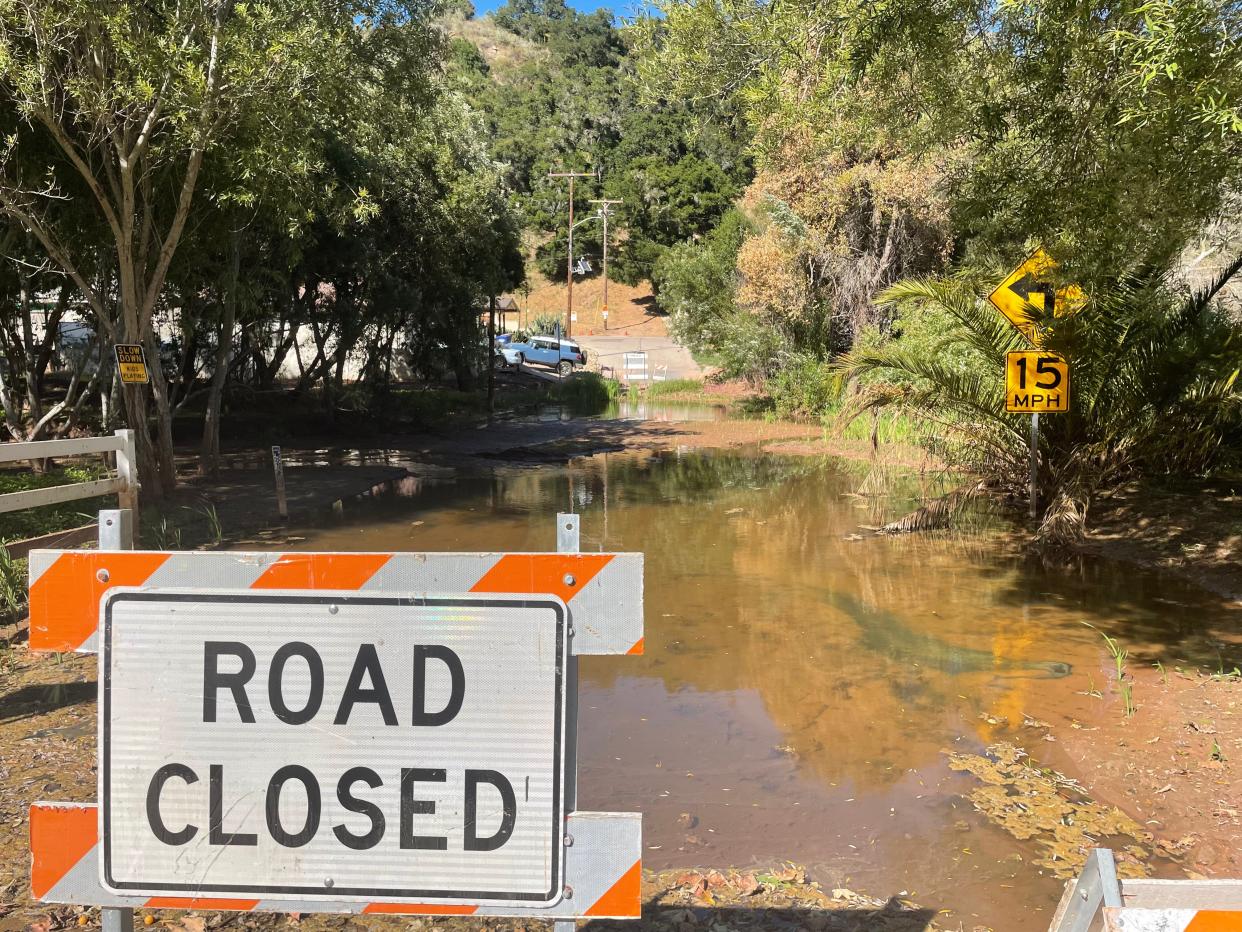
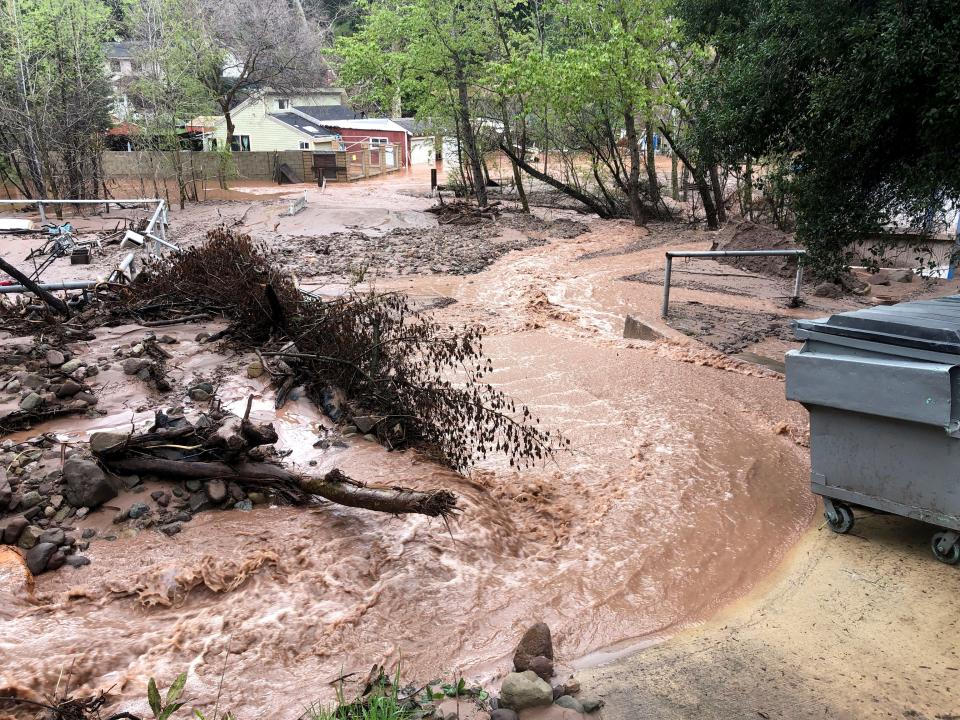
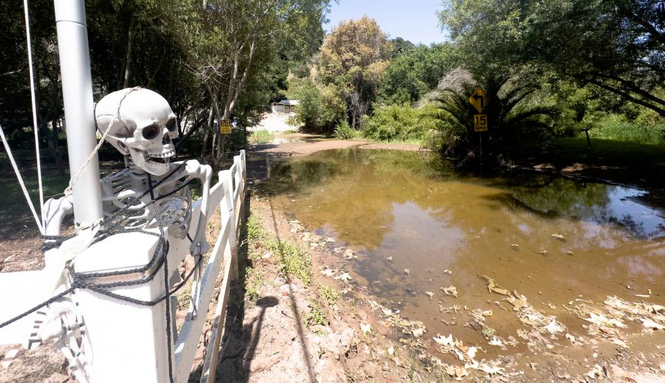
As January storms pummeled the area, authorities ordered evacuations, homes were damaged and the low-water crossing at Camp Chaffee and Coyote Creek flooded. Despite a few attempts to clear the county-owned crossing, the route has remained blocked.
Six months later, several feet of mud and slow-moving water persist.
"It is completely saturated," county Public Works Director Jeff Pratt said.
Until it dries out and the water stops flowing, it is pointless to keep trying to clear it, he said. That means, for now, residents have to use Skyhigh on the other side of Camp Chaffee.
But for the neighborhood, the crossing may be one of the easier problems to solve. The more complicated one is how to get rid of tons of mud and debris that came down the creek during the storms and got stuck there.
If the channel doesn't get cleared before the next rainy season, the area could face yet another round of flooding. Some worry it could be even worse than last winter.

'We could lose our homes'
Nikki Katz has lived in the community for more than a decade. She loves the neighborhood she called beautiful and peaceful – "a great place to raise a family."
Coyote Creek runs along the tree-filled area near county parkland. As storms piled up this winter, she hit the phones, calling elected officials and agencies to see if they could offer assistance. She said she was grateful the county and others helped find a potential fix.
The Natural Resources Conservation Service, part of the U.S. Department of Agriculture, is processing a grant application that may help dig out the creek bed.
The county cannot work on private property, which would be considered a gift of public funds, Pratt said. But with a grant from the federal agency, it can act as a sponsor for the community project.
The grant would fund 75% of the estimated $1.5 million cost. The remaining 25%, or roughly $375,000, still needs to be secured. At least initially, much of the match may have to be paid by residents.
The county's public works department plans to seek disaster assistance funds from the state Office of Emergency Services that could pay up to 75% of the local match, said Glenn Shephard, director of the department's watershed protection agency. But if approved, it may only be available to reimburse costs after the work is complete, he said.
Katz and her neighbors already have started planning potential fundraisers, combing through other grant possibilities and setting up a website to provide information and seek donations. There's no question of the need, according to residents.
"Without the work, we could lose our homes," Katz said. "The creek is going to keep rising with every storm that we get."
Thomas Fire fallout
The proposed project would span roughly 3,300 feet on Coyote Creek from the confluence of the Ventura River to 500 feet upstream of Camp Chaffee Road, according to the county public works department. More than 40% of the project is on county parkland.
Plans call for digging out a channel 25 feet wide and roughly 5 feet deep. In all, the work would remove an estimated 21,400 cubic yards of sediment.
In 2017, a similar project happened when the area flooded. With an NRCS grant, the county helped residents clear the creek but not to the extent currently proposed. After the work, the residents were responsible for keeping the creek bed clear. That didn't always happen, county officials said.
Residents were given few options to do the work and told to use hand tools to clear out what would end up being a large volume of debris and vegetation, said Piper Presley, who lives in the neighborhood. To use anything else would have required complex and costly permits from multiple regulatory agencies, she said.
Even if the channel was maintained, the amount of debris that came down this winter would still have caused problems. Officials said the Thomas Fire was at least partly to blame. The December 2017 blaze scorched the hillsides upstream. During one of the area's wettest winters in years, much of that burned debris swept downstream.
Flooding risk remains
The project is expected to help relieve flooding, but the risks won't go away, officials said.
Much of the neighborhood is considered at higher risk of flooding, according to maps from the Federal Emergency Management Agency. Several structures, including homes, are located in the "floodway," an area FEMA says should be kept clear for floodwaters. The homes in the area pre-date those maps.
"Cleaning out the channel would help, but the risk doesn't go to zero," Shephard said.
If the NRCS grant is approved, the county estimates it would take at least three to four months before works starts in the creek bed. Officials would need to secure the rest of the funding and permits from federal and state regulatory agencies.
Crews also may be racing the weather. If winter storms start to roll in, the work may have to wait until March or April.
One way out
As soon as the water stops flowing over the crossing, Pratt said crews will clear it. He thought that would have happened by now, but a small flow has continued.
Agencies and residents came together at a recent town hall meeting organized by the Ventura County Sheriff's Office of Emergency Services and county Supervisor Matt LaVere's office to address concerns. In a fire, some residents said they worried people would be trapped in homes or cars with just the one winding, narrow way out.
With the limited access, the Ventura County Fire Department checked to see if its equipment could make it up Skyhigh Drive. It did, Deputy Chief Chad Cook told residents. But keeping the road clear in case of a fire is paramount, he said.
The department also used computer modeling to see how fast flames could potentially overwhelm the community. Under normal weather conditions – without gusty winds – most of the simulated wildfires would remain relatively small, he said. On days with dangerous fire conditions, the department would want additional precautions, which could include patrols and parking restrictions, he said.
As an emergency fail-safe, officials also are creating a temporary refuge area, a spot in the community where people could quickly get to safety.
Cheri Carlson covers the environment and county government for the Ventura County Star. Reach her at cheri.carlson@vcstar.com or 805-437-0260.
This article originally appeared on Ventura County Star: Problems persist in a Ventura-area neighborhood months after storms

