Hurricane Tammy wallops northeast Caribbean islands


Hurricane Tammy is moving north of the Lesser Antilles, after threatening the region with flooding downpours, rip currents and damaging winds, AccuWeather hurricane experts say. The storm is the 19th named tropical system and seventh hurricane of the 2023 Atlantic season thus far.
Hurricane warnings were issued for part of the region prior to Tammy making landfall on the island of Barbuda at 9:15 p.m. EDT Saturday evening. The storm produced winds of up to 90 mph for a time in Barbuda earlier in the weekend.
 |
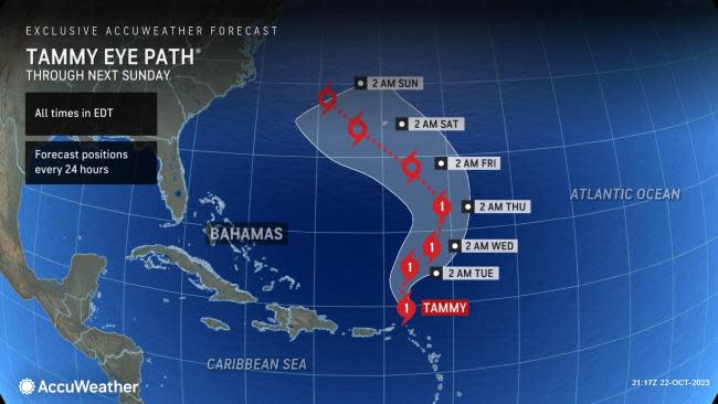
As of Monday morning, Tammy was located 230 miles north-northwest of Anguilla. It was packing maximum sustained winds of 80 mph (about 130 km/h) with higher gusts and was moving north at 10 mph.
Based on the latest AccuWeather Eye Path® forecast, Tammy will move farther away from the Lesser Antilles and into the open Atlantic as a Category 1 hurricane on the Saffir-Simpson Hurricane Wind Scale (SSHWS) with maximum sustained winds in the range of 74-110 mph (119-177 km/h) through the weekend.
 |
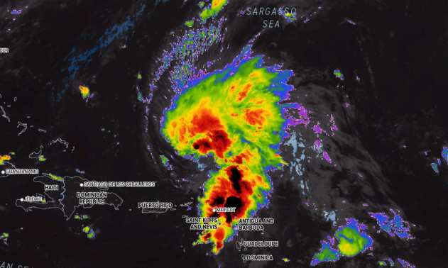
Hurricane Tammy, as seen on AccuWeather RealVue™ Enhanced Satellite, as of Monday morning, Oct. 23, 2023. |
More than a dozen island nations there were impacted by pounding surf, dangerous rip currents, heavy rain and strong winds as Tammy moved through, according to AccuWeather meteorologists. They were Anguilla, Antigua and Barbuda, Barbados, Dominica, Guadeloupe, Martinique, Montserrat, Saba and St. Eustatius, St. Kitts and Nevis, St. Maarten, St. Martin, St. Barthelemy and the British and U.S. Virgin Islands.
Because of the rain and wind impacts in the region, Tammy is rated as 1 on the AccuWeather RealImpact™ Scale for Hurricanes.
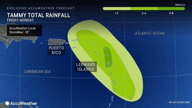
"Tammy [was forecast to] bring heavy rain from Barbados and St. Lucia through the Virgin Islands through Monday, producing a wide swath of 1-2 inches (25-50 mm) of rain for much of the area," said Pydynowski. "A smaller area of 2-4 inches (50-100 mm) is forecast from Martinique to Saint Martin, along with 4-8 inches (100-200 mm) in Antigua and Barbuda."
 |
"The storm [was forecast to] bring sustained tropical-storm-force winds (39-73 mph, or 62-117 km/h) from Martinique through the British Virgin Islands, with a wide area of 40-60 mph (60-100 km/h) wind gusts," added Pydynowski. "The strongest winds [were forecast to] be over the northern Leeward Islands where winds can gust to 60-80 mph (100-130 km/h)."
The AccuWeather Local StormMax™ for rain is 10 inches (250 mm).
Tammy will move away from the northern Leeward Islands into the early part of the new week.
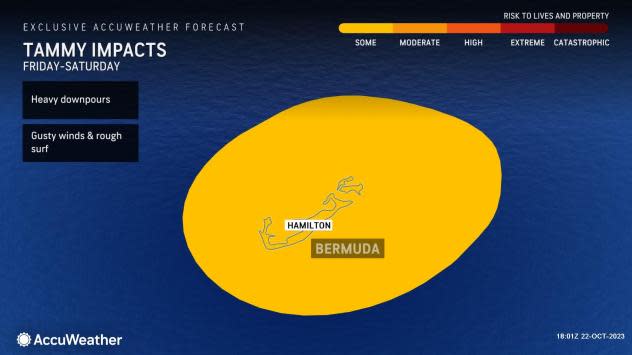
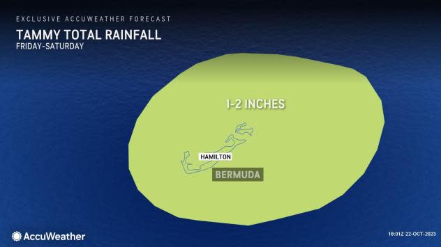
Later in the week, the weather pattern is expected to bring Tammy close enough that Bermuda will be in play for possible impacts.
 |
AccuWeather tropical meteorologists say that Tammy can bring 1-2 inches (25-50 mm) of rain to the island nation from Friday into Saturday, with wind gusts ranging from 40-60 mph (60-100 km/h.
 |
"The storm is expected to maintain hurricane intensity through much of [the] week," said Pydynowski.
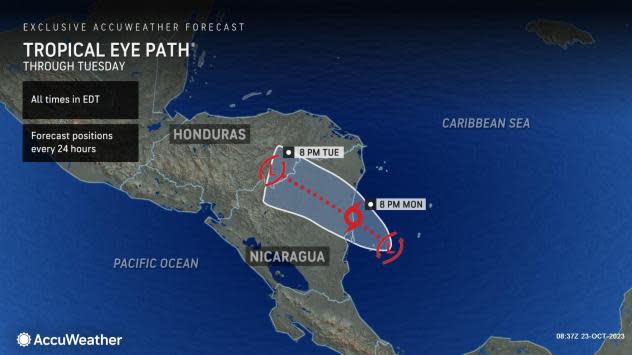
At this point, AccuWeather hurricane experts will be keeping an eye on a new area of low pressure that could become a tropical storm early this week in the southwestern Caribbean Sea.
 |
"A slow-developing area of low pressure in the southwestern Caribbean will have a chance to develop and organize [in the new] week," Pydynowski said.
The Atlantic hurricane season runs from June 1 to Nov. 30 each year.
Want next-level safety, ad-free? Unlock advanced, hyperlocal severe weather alerts when you subscribe to Premium+ on the AccuWeather app. AccuWeather Alerts™ are prompted by our expert meteorologists who monitor and analyze dangerous weather risks 24/7 to keep you and your family safer.
