Typhoon Doksuri impacting the Philippines, heading toward Taiwan next


 |
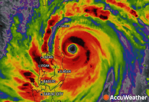
Typhoon Doksuri late on July 25, 2023 local time, approaching the Philippines on infrared satellite. |
A strengthening typhoon churning in the western Pacific Ocean is impacting the Philippines before it takes aim at Taiwan, Hong Kong and parts of southern China.
As of Tuesday night, local time, Doksuri, known as Egay in the Philippines, was the equivalent of a Category 3 hurricane on the Saffir-Simpson scale. The storm had strengthened into a super typhoon on Monday, but lost some wind intensity on Tuesday, causing it to fall just below the threshold of super typhoon status.
Doksuri can strengthen over the next day or so as it tracks northwest toward the Philippines before it starts to lose wind intensity, AccuWeather Senior Meteorologist Jason Nicholls said.
 |
Typhoon Doksuri late on July 25, 2023 local time, approaching the Philippines on radar. |
As the strengthening storm hurtled toward the Philippines' largest and most populated island, Luzon, Philippine President Ferdinand R. Marcos Jr. suspended all public school classes and closed government offices in the capital region Monday, save for those performing critical services. The suspension was also in part due to a three-day strike by transport workers, according to CNN.
Thousands were ordered to evacuate from 11 towns in the coastal province of Cagayan in the Philippines, The Associated Press reported. Sea travel has also been halted in waters surrounding the northern part of the islands.
After the core of the storm enters the Luzon Strait early Wednesday, it is expected to track near or just south of southern Taiwan Wednesday night into Thursday, local time.
Landfall is possible in eastern Guangdong or the Fujian province of China Friday, local time, according to Nicholls.
 |
The forecast track of Typhoon Doksuri as of Tuesday night, July 25, local time. |
Due to the impacts of heavy rain and strong winds, Doksuri is a 3 on the AccuWeather RealImpact™ Scale for Tropical Cyclones in the northern Philippines and Taiwan and a 2 in southeast China.
As Doksuri sideswipes the Philippines, it is expected to bring heavy rainfall to the northern end of the island through Wednesday. Widespread rainfall of 2-4 inches (50-100 mm) is in the forecast across much of the archipelago with 8-12 inches (900 mm) in northern Luzon and the Batanes and Babuyan Islands.
Hazards from this rainfall include widespread flooding and mudslides, common and deadly threats that typhoons pose in the Philippines. One of the most recent typhoons to cause mudslides was Tropical Storm Nalgae, known as Paeng in the Philippines, which struck the nation on Oct. 29, 2022. It unleashed unrelenting rainfall that spurred landslides and flooding, landing it among the season's deadliest and most destructive storms to hit the archipelago.
 |
Rescuers carry a body which they retrieved after Tropical Storm Nalgae hit Maguindanao's Datu Odin Sinsuat town, southern Philippines on Saturday Oct. 29, 2022. Flash floods and landslides set off by torrential rains left dozens of people dead, including in a hard-hit southern Philippine province, where many villagers are feared missing and buried in a deluge of rainwater, mud, rocks and trees, officials said Saturday. (AP Photo) |
Another 4-8 inches of rainfall is expected across Taiwan later Tuesday into Friday, local time, with 8-12 inches (200-300 mm) in southern Taiwan. Similar rainfall is expected across eastern Guangdong and Fujian province of China Thursday into Saturday, local time. Across the rest of eastern China from western Guangdong province to Jiangsu, 1-4 inches (25-100 mm) is forecast to fall, which can result in areas of flash flooding.
The AccuWeather Local StormMax™ calls for 36 inches (900 mm) of rain from the Philippines to eastern Guangdong and Fujian province of China.
Strong winds will also pose a threat this week. Wind gusts of 120-140 mph (190-225 km/h) are possible across southern Taiwan and Batanes and Babuyan Islands from Tuesday night into Thursday, local time, with an AccuWeather Local StormMax™ of 160 mph (257 km/h).
"Widespread damage to trees, some power structures and power outages are possible," Nicholls said. "Wind gusts of 100-120 mph (160-190 km/h) are possible along the coast of China across and the rest of Taiwan with the risk of damage and power outages."
Farther north, wind gusts of up to 60 mph (100 km/h) could reach around Shanghai late in the week.
"Conditions should remain conducive for new tropical development over the Philippine Sea later this week," Nicholls said. "This potential storm can eventually threaten eastern China or Japan next week."
Track these severe weather conditions and more with the AccuWeather app. For next-level safety, unlock AccuWeather Alerts™ with Premium+. These advanced, hyperlocal notifications are prompted by our expert meteorologists and are often delivered much further ahead of government warnings when possible.
