Strong to severe storms possible on Saturday from Milwaukee area southward; best chance for strong storms will be near Illinois border
Thunderstorms are forecast for southern Wisconsin and the Milwaukee area on Saturday and some of the storms could become severe, forecasters say.
Forecasters will be watching the situation closely on Saturday, said Kevin Wagner, a meteorologist with the National Weather Service in Sullivan.
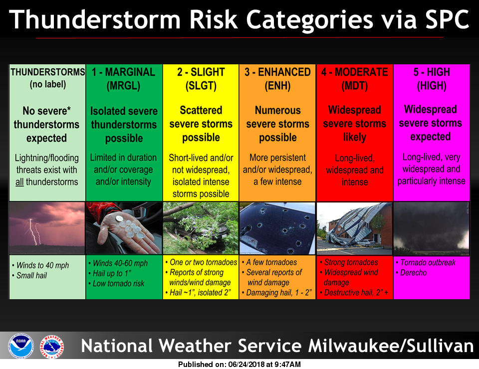
The far southern portion of Wisconsin, roughly south and west of a line from Lake Geneva to Madison has been placed in the "slight" risk category, which is the second-lowest risk level, on a scale used by the national Storm Prediction Center.
The remainder of southern Wisconsin, including the entire Milwaukee metro area, is under a "marginal" risk for severe storms. "Marginal" is the lowest severe risk level of 1 out of 5.
"Our biggest concern is along the Wisconsin-Illinois border — those counties in the far southern part of the state," Wagner said. "There is definitely a potential on Saturday afternoon to see some severe weather."

In a statement issued early Saturday, the weather service said "large hail and damaging winds are the main concerns, but there could be a brief window for a tornado or two," for Saturday afternoon or evening.
Related: Lack of springtime rain leads to high fire risk for portions of Wisconsin
That does not mean severe storms are a certainty, Wagner said. All the atmospheric ingredients have to come together at the right time for strong to severe storms to form.
Gusty east winds bringing cooler air to areas along and near Lake Michigan are likely to limit the severe threat for lakeshore counties, said J.J. Wood, a weather service meteorologist in Sullivan.
Those areas could still see a strong storm or two, however, on Saturday afternoon and evening, Wood said.
Anyone with outdoor plans on Saturday afternoon or evening should keep an eye on the forecast, Wagner said.
The storm system is the same one that brought tornadoes to the Plains on Friday.

Rain is a pretty good bet on Saturday. "Anywhere from 3 p.m. to 7 p.m. on Saturday, I think, are our best chances for rain," Wagner said.
Rain chances on Saturday range from 80% in Milwaukee to 90% in Waukesha to 100% in Lake Geneva, according to the weather service.
On Sunday, southern Wisconsin should see cloudy skies, a 30% chance of rain and a high around 55 degrees.
More storms are possible again on Tuesday.
Weather radar

Our subscribers make this reporting possible. Please consider supporting local journalism by subscribing to the Journal Sentinel at jsonline.com/deal.
DOWNLOAD THE APP: Get the latest news, sports and more
Contact Joe Taschler at (414) 224-2554 or jtaschler@gannett.com. Follow him on Twitter at @JoeTaschler or Facebook at facebook.com/joe.taschler.1.
This article originally appeared on Milwaukee Journal Sentinel: Severe storms possible on Saturday, especially south of Milwaukee

