Intense storm brings heavy wind & snow to parts of B.C.

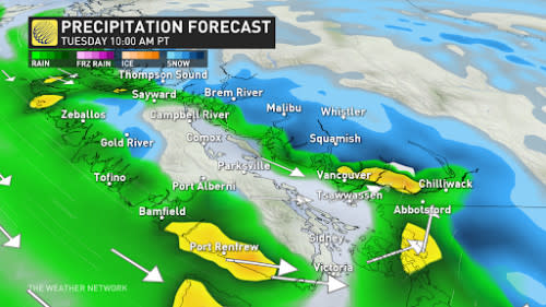
Persistent low-elevation snowfall and strong winds will continue in British Columbia, with notably strong gusts targeting Victoria Tuesday.
Following a light dusting of snow in Vancouver on Monday, the precipitation will transition to rain. Some snow will linger on highway passes and some worrisome winds will flow into the Juan de Fuca Strait.
The triple whammy of rain, snow, and gusty wind started across British Columbia at the start of the week. This active weather comes ahead of the cold air and rare arctic outbreak that takes aim as we move towards Thursday.
GET THE LATEST: Winter returns with a rare El Niño chill coming to B.C.
Snowfall is expected to persist above 600 m, and freezing levels will remain relatively low in the coming days. Anticipate substantial snow accumulation, particularly for highway passes, with amounts reaching 40-60 cm, creating challenging driving conditions along the Sea-to-Sky and Coquihalla routes.
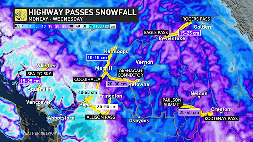
The eastern Fraser Valley, including Abbotsford, Mission, and Hope, may see 5-15 cm of snow before a transition to rain. The Interior and the Okanagan have the potential for accumulating snow, with 5-15 cm possible from Monday night through Wednesday morning.
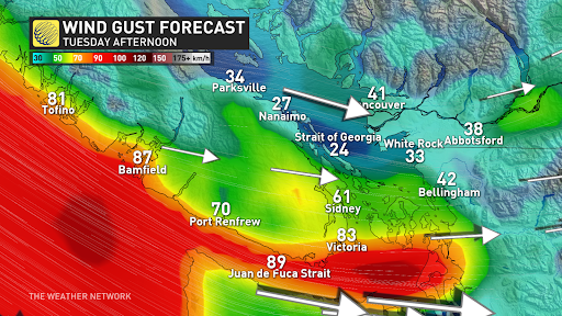
As a cold front passes through on Tuesday, rain and gusty winds may affect inland sections of the Lower Mainland. Confidence is uncertain regarding post-cold front conditions, but there's a risk of afternoon wind gusts exceeding 70 km/h, increasing the potential for power outages.
DON'T MISS: Winter to finally show up in January as El Niño bested by polar vortex
Western Vancouver Island will experience heavy rainfall and winds, raising concerns about wind direction through the Juan de Fuca Strait.
Models predict wind gusts over 70 km/h, possibly exceeding 90 km/hr, which may impact Victoria and the extreme South Coast. Along with strong winds, there is also a threat of lightning. Ferry cancellations and an escalation of power outages are expected on Tuesday as the cold front passes and precipitation rates decrease.
A noteworthy cold spell will spread across Western Canada, culminating in an arctic outflow event closing out the week in British Columbia.
Stay with The Weather Network for more forecast information and updates as we monitor your weather across B.C.
