Strong storm threatens Newfoundland, parts of Nova Scotia with damaging winds
A growing storm over parts of the East Coast will bring heavy rain, gusty winds, and a power outage risk through the beginning of the new work week.
DON'T MISS: A ‘historically strong’ El Niño is possible heading into winter
This latest storm is on track to grow much stronger than the one that brought a raw and miserable weekend to much of Atlantic Canada. Wind and rainfall warnings are in effect, as well as special weather statements for parts of Nova Scotia, including Halifax.
The combination of high winds and rain-soaked soils could lead to the risk for localized power outages.
Stormy start to the week with potent Colorado low
Areas: The Atlantic provinces
Timing: MONDAY
Weather: Threat for damaging winds, heavy rain and localized flooding.
Visit our Complete Guide to Fall 2023 for an in-depth look at the Fall Forecast, tips to plan for it and much more!
A Colorado low that brought severe thunderstorms and tornadoes to the American Plains earlier in the week scooted off the U.S. East Coast on Sunday, turning toward the north as it gets a second wind on approach to Atlantic Canada.
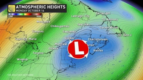
As the system strengthened through the overnight on Sunday, the minimum central pressure dropped close to 970 mb, a signal for rough times ahead for folks beneath the storm.
The strong pressure gradient has caused winds to pick up across Newfoundland, beginning in the south on Monday morning and spreading across the island into the late morning and afternoon as our low-pressure system moves north.
RELATED: How a super typhoon will alter Canada's late-October weather
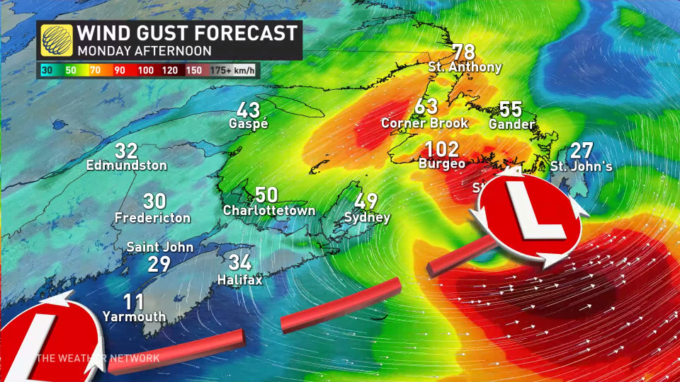
Widespread wind gusts of 60-90 km/h are likely across Newfoundland throughout the day Monday, with higher gusts possible in coastal areas. Wind gusts between 40-60 km/h are expected for P.E.I and Cape Breton through Monday afternoon. Through the overnight hours on Monday, winds will strengthen briefly for the Avalon reaching up to 60 km/h.
The combination of high winds and rain-soaked soils could lead to the risk for localized power outages.
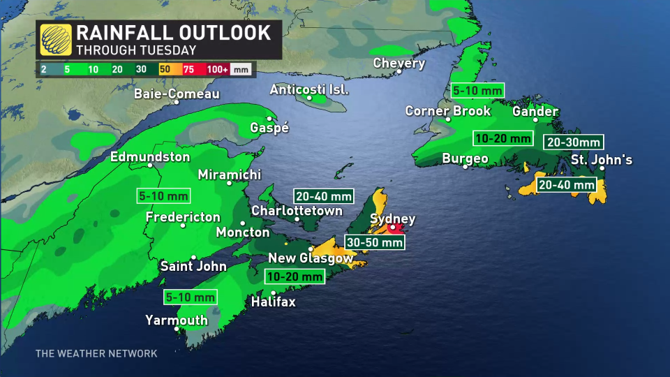
Additional rainfall totals of 30-50 mm are likely through Tuesday across eastern Newfoundland and eastern Nova Scotia. Meanwhile, between 5-15 mm of rain is expected for major cities like Halifax, Moncton, and Fredericton.
Conditions will gradually improve overnight Monday into Tuesday as the system departs to the east. Clouds will linger into Tuesday morning, along with a chance for residual showers on the Avalon.
Stay with The Weather Network for all the latest on conditions across Atlantic Canada.

