Afternoon storms cause no major damage in Lansing area; more storms possible
Update (5:30 p.m.): No major damage was reported in the Lansing area from Wednesday afternoon's storms, but forecasters warned that more storms could pass through the region on Wednesday night. Some of the storms could be severe and produce heavy rain, they said.
Update (3:10 p.m.): The tornado warning for Dansville and Stockbridge has expired.
Update (2:54 p.m.): A tornado warning has been issued for the Dansville and Stockbridge areas, the National Weather Service said.
The warning was based on radar images and issued until about 3 p.m.
Original post: LANSING — Several rounds of "potentially destructive" thunderstorms are forecast across much of the southern Lower Peninsula Wednesday, according to a National Weather Service Grand Rapids office meteorologist.
"There will be multiple rounds of storms," meteorologist Jim Matczko said. "Maybe a couple of times a year (these systems form)," he said.
Matczko said the storms could move across the state at 30 to 50 mph with winds of more than 60 mph. Those types of winds, he said, could cause significant damage, including to trees, power lines and property. People who live in wooded areas should take cover when the storms move through.
A severe thunderstorm watch went into effect for the western and southern Lower Peninsula at 10 a.m. The biggest threat is from noon to 8 p.m. today. A warning is in effect for the area from Ludington to Pentwater along Lake Michigan.
"Damaging winds are the greatest threat with large hail, isolated tornadoes, and localized flooding also possible. Stay weather aware today," the NWS urged in an online post overnight.
The NWS said temperatures today could reach about 88 degrees with winds up to 20 mph.
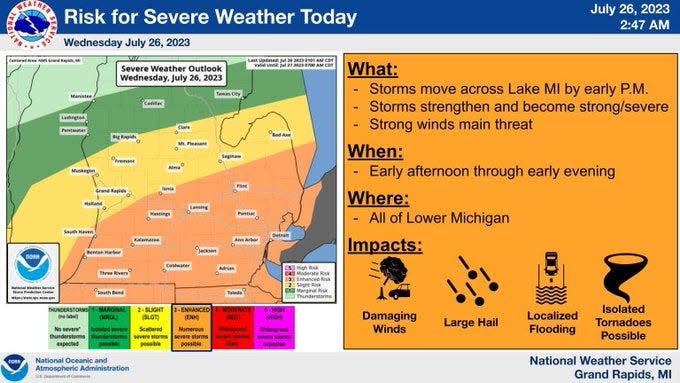
Storms are expected to move eastward across Lake Michigan by early afternoon and then strengthen.
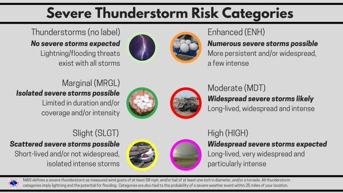
The entire Lansing region is included in the enhanced threat area which stretches from South Haven to Ionia to the Thumb area, and south into Indiana and Ohio.
The area further north from Holland to Muskegon and east to Saginaw Bay faces a slight risk for scattered severe storms while the risk diminishes to "marginal" further north.
Consumers Energy officials said in a release the company is preparing for two severe weather events, the damaging winds, storms and extreme heat that are expected in many parts of Lower Michigan starting Wednesday afternoon through Friday. The company said some of the storms are expected to include heavy rain, hail and strong wind gusts that could cause power outages.
This is a developing story. Check back for updates.
This article originally appeared on Lansing State Journal: Afternoon storms cause no major damage in Lansing area; more storms possible
