Strong winds sweep the GTA overnight, snow on tap for some Friday
An active day across Ontario will roll into a busy night as the potent storm that brought rain, ice, and snow to the province continues producing gusty winds into the nighttime hours.
The strongest winds will unfold around and south of the Greater Toronto Area (GTA), where we’re likely to see gusts of 60-80 km/h persist through the overnight hours Thursday into Friday morning.
DON’T MISS: It may be mild but the snowiest months are just ahead for these parts of Canada
Folks on the Niagara Peninsula stand to see the strongest gusts overnight Thursday, where Environment and Climate Change Canada issued wind warnings through Friday morning.
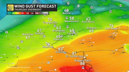
Communities under the wind warning—including Niagara Falls, Welland, and Simcoe—could see winds peak at 90 km/h at times.
These gusty winds will lead to an enduring risk for trash cans and small objects to roll around, as well as the risk for sporadic tree branch damage and power outages.
Winds will calm down by Friday morning as the Texas low responsible for this bout of active weather pulls away from the region. However, cooler air blowing in on westerly winds will give rise to bands of lake-effect snow through the day Friday.
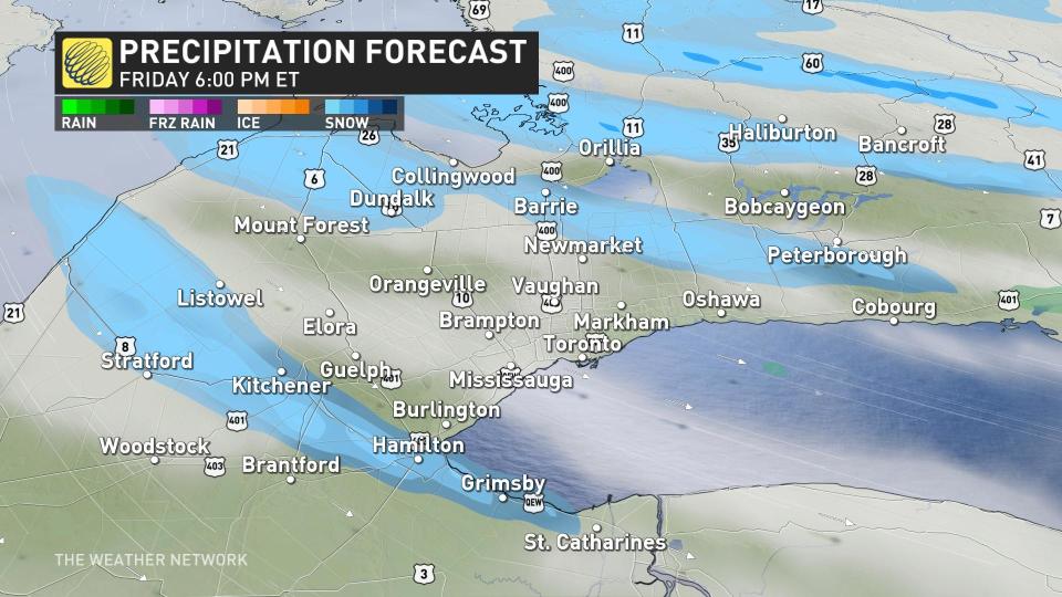
Bands of snow will develop along the shores of Lake Huron and Georgian Bay early Friday morning, growing more organized and extending farther inland through the late morning and afternoon hours.
Most of the snow will remain confined to the traditional snowbelt regions, with bands occasionally meandering into the Greater Toronto and Hamilton Area.
Anyone commuting through the affected areas on Friday should plan ahead for the potential for slick roads and lower visibility.
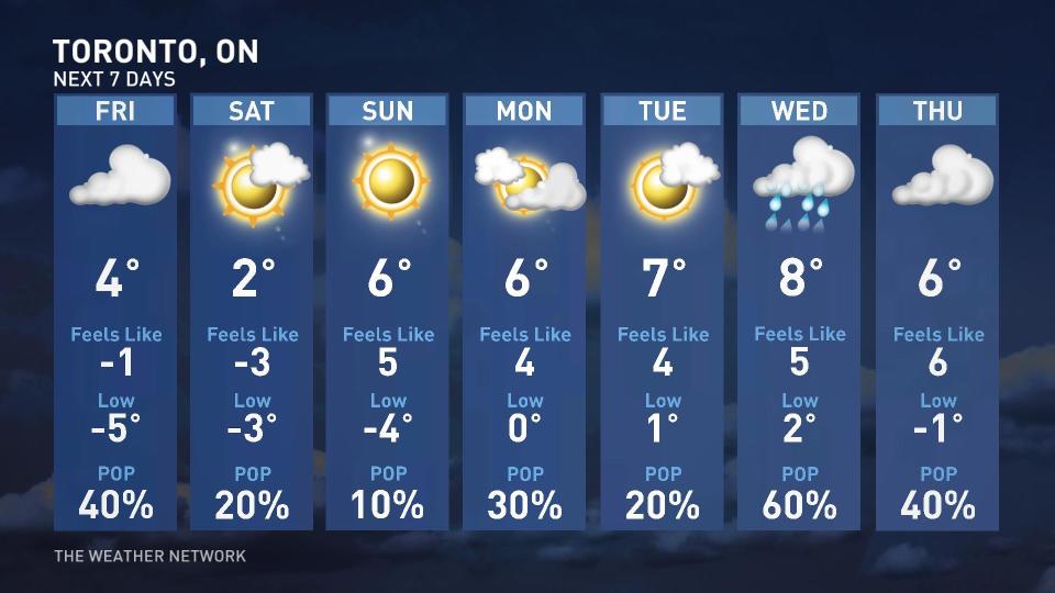
Looking ahead, southern Ontario could have another tease of spring-like weather moving into next week.
Forecasters expect daytime highs to reach the mid-single digits in Toronto on Sunday and remain there for the duration of the week—no small feat for the middle of February, when the city’s average high temperature sits right around the freezing mark.
Occasional bouts of unsettled weather are possible amid this above-seasonal pattern, including a decent chance for precipitation by the latter half of next week.
Stay with The Weather Network for the latest on conditions across Ontario.

