Strongest winds since Sandy could bring widespread outages
With Isaias back down to a tropical storm after making landfall as a hurricane, you might expect its winds to weaken. While that will happen briefly Tuesday morning, by late afternoon, as the storm reaches the New York City area, it will get a boost of power that should accelerate winds to the strongest the region has seen since Superstorm Sandy.
That added boost of energy will come from a merger with the jet stream, a strong river of air in the clouds diving south from Canada and into the Mid-Atlantic and Northeast. The jet stream will merge with the circulation of Isaias, delivering a jolt of energy and repowering the system.
This jet stream merger with #Isaias should deliver a jolt of energy driving wind gusts back up above 80 mph for coastal areas near NYC. It will be interesting to see if this comes to fruition. If it does, prepare for widespread power outages along densely populated I-95 corridor. pic.twitter.com/pzSveElx8C
— Jeff Berardelli (@WeatherProf) August 4, 2020
As a result, sustained winds just above the surface will be racing at 90 mph on Tuesday afternoon. As the system rides northward from the Delmarva Peninsula toward Philadelphia, New Jersey, New York City and southern New England, tropical downpours will tap strong winds up above and force those winds down toward the ground.
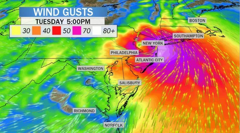
The turbulent mixing will result in pockets of hurricane-force wind gusts, with various computer models forecasting gusts from 75 to 90 mph. The strongest gusts are expected on the New Jersey coast, the south shore of Long Island and Connecticut. Gusts over 70 mph are indicated by the purple and white contours on the map below.
The burst of wind is likely to come on suddenly during the afternoon, last for only a few hours, and then move out as fast as it moved in during the early evening. In its wake, widespread power outages are a likely outcome from falling trees and power lines.
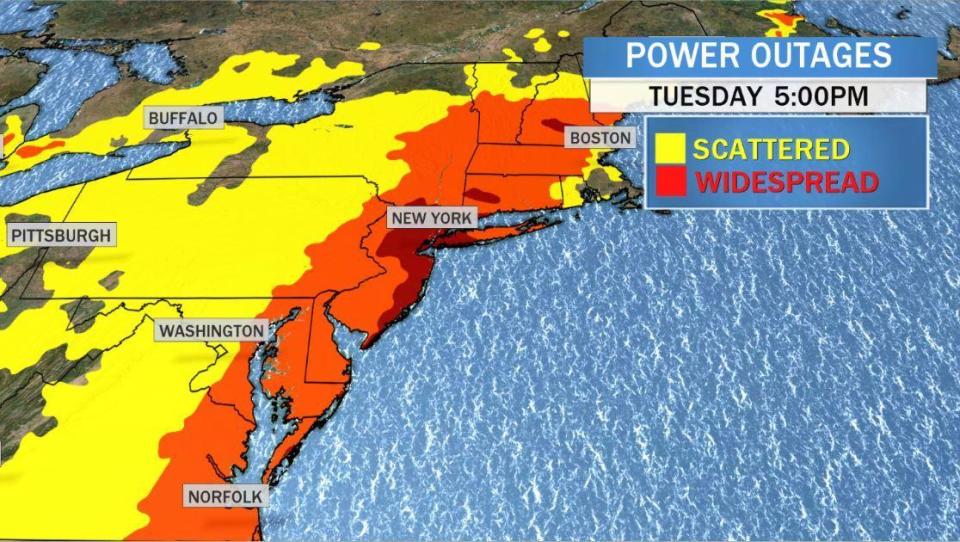
The deeper shades of red on the map below illustrate the focus for expected power outages in the most densely populated parts of the country around New Jersey, New York City and Long Island. Residents should be prepared for the possibility of being without lights, air conditioning and internet for an extended period of time.
On the western side of the storm, torrential rains will be the biggest impact. From central Virginia, including Washington D.C., northward through eastern Pennsylvania, western New Jersey and into upstate New York, a solid path of 3 to 5 inches of rain will fall in a relatively short period of time. This will likely cause pockets of flash flooding, especially at the bottom of hills and near rivers.
The IBM GRAF forecast model for rain totals by Tuesday evening. pic.twitter.com/r9sZZCGdgn
— John Collins (@collinsvoxwx) August 4, 2020
By Tuesday night, the rain and wind will quickly taper off as the system moves quickly through New England and into Canada. As it does so, damaging winds are possible into the Berkshire Mountains of Massachusetts and the hills of Vermont and New Hampshire.
Expected timeline for presumptive Democratic nominee Joe Biden's VP pick and who it may be
Boeing to stop production of 747 jumbo jet in 2022
Tracking Tropical Storm Isaias as millions could face flooding rains, high winds

