Stunning Instagram Hotspot Is Really a Drainage Ditch
- Oops!Something went wrong.Please try again later.
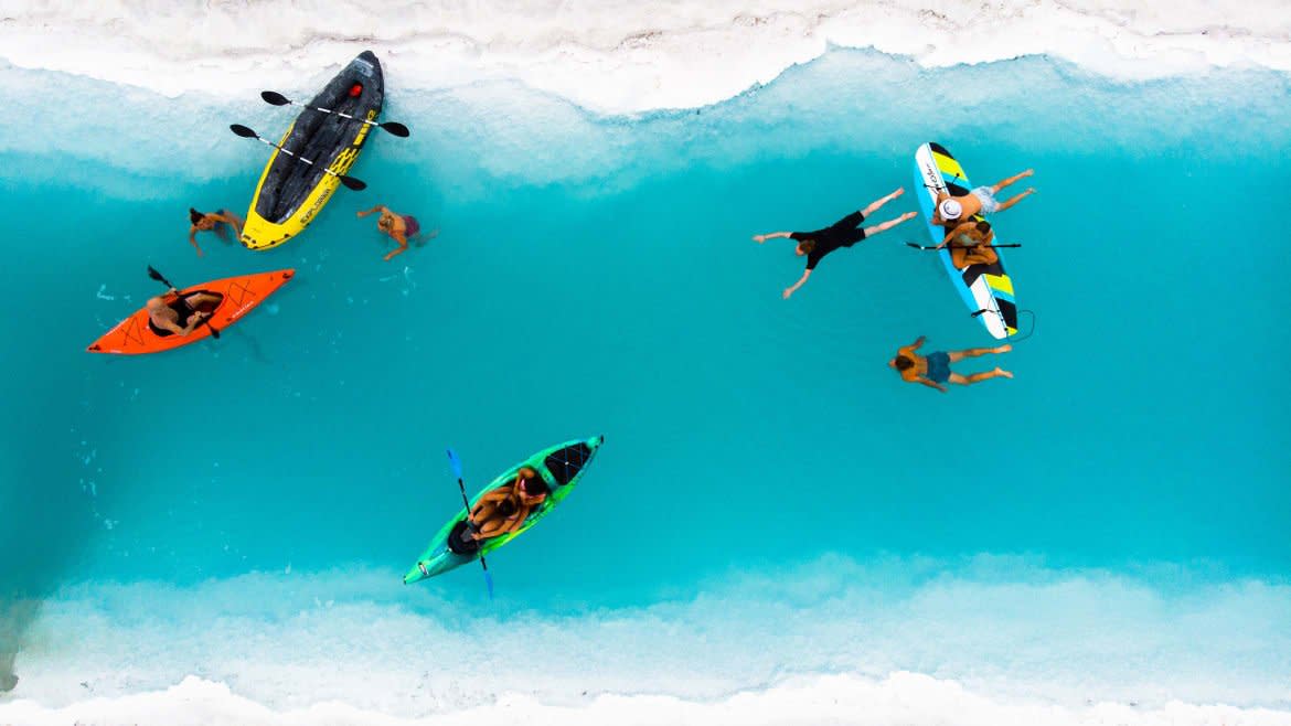
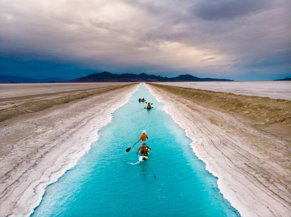
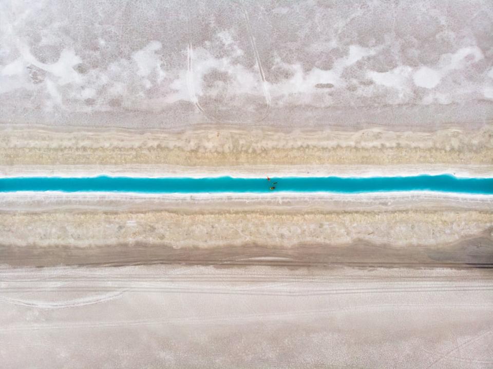
It’s not a mirage. In Western Utah, among the Bonneville Salt Flats, are some of the most beautiful waters to be found anywhere. It looks as though a sliver of the Aegean Sea with its aquamarine-colored water has been transplanted to Mars—creating this singular strip of life carving its way through an otherwise barren wasteland.
In reality it is a drainage ditch, and whether or not you can swim in it or should, well, that’s a point of contention.
The Bonneville Salt Flats first started to form at the end of the last Ice Age, when Lake Bonneville, which covered approximately one-third of Utah, began to recede. This freshwater lake left large deposits of minerals in the soil, including gypsum, potassium chloride (potash), and plenty of sodium chloride (table salt). For thousands of years, the crust has been growing thicker and thicker, but within the last 50-years, things have started to change.
No—it’s not climate change, although as always, it has something to do with it, and it’s not irresponsible use by travelers and Instagrammers, although that certainly isn’t helping its case either. It’s not even racing, which occurs frequently on the Flats, as people try to clock the highest speeds ever recorded at the annual Speed Week and beyond. Instead, the story of the thinning salt crust involves potash miners, who have been mining the land for the valuable chemical for over a hundred years.
And yet, despite evidence presented by the University of Utah that mining, as well as the supposed mining mitigation efforts, are damaging one of Earth’s most unique places, that isn’t even the most controversial story to come out of the Salt Flats.
Instead, the industry responsible for the deterioration of the Bonneville Salt Flats is behind the accidental creation of a viral tourist attraction—one they and the Bureau of Land Management (BLM) are now struggling to keep visitors away from and which, in the process, has further reignited the age-old question of what our most prized public lands should be used for—and, perhaps more importantly, how they should be managed.
“If you post it, they will come,” says Matt Newey, a 24-year-old photographer based in Provo, Utah, and perhaps the reason “the Blue Canal,” as it’s now called, first went viral.
“People, without fail, either message me asking me how to get there or if the water is really that blue, or Karens come out and say I’m the devil and I’m trying to kill people,” he said. “I’m trying to show people how cool Utah is.”
His now infamous pictures have been reposted by several major Instagram accounts, including nature, earthpix, and Outside TV. Most of the comments on these posts are flooded with amazement, curiosity, and wanderlust, until inevitably, a debate breaks out over whether the water is toxic, if it is legal to go there, if the place even exists, or if it truly looks like that at all.
The answers to these questions are all complex.
When the post went viral in June of 2020, Newey says “people started going there like crazy.” And it wasn’t long before state and federal authorities cracked down best they could.
The BLM, which has leased the canals to Intrepid Potash for mining activities, was quick to release a statement warning the public that the canals are “industrial facilities,” and recommended that “the public should not access, swim, float, kayak, canoe, or pursue any other recreation activities in these industrial canals.”
Kevin Oliver, the BLM’s West District Manager, added to this messaging, telling the Salt Lake Tribune that the canals, “are not appropriate for recreation due to industrial design and other unknown hazards.”
While this didn’t do much to slow people from coming for a viral shot for themselves, from this, Newey speculates, was born the widely spread rumor, one that populates plenty of Instagram comments, that the water itself is toxic and full of potentially carcinogenic chemicals.
While the canal is technically a drainage ditch (which in its own right has sparked debate over why someone would want to go there), the water itself is hardly toxic.
Instead, potash mining is a relatively clean operation. It does not involve unearthing toxic chemicals but instead, the canals are a way for Intrepid Mining to move water across the Flats, collecting potash, until they arrive at salt evaporation fields, where the potash can then be extracted. The salt growing at the sediment-water interface makes the bottom of the canals white, so there is a greater reflection of the sky color, giving the water its stunning blue hues.
According to the University of Utah Geologist, Brenda Bowen, “the water is not toxic.” She added, importantly, “This is not to say you should drink it or really even swim in it, but it is definitely not filled with carcinogens.”
But potentially toxic water isn’t the only issue.
There are two other obstacles, both of which are spelled out in the Salt Lake Tribune article as well as all over Instagram. The first is that “access requires crossing private land that may have ‘no trespassing’ signs.” While true, this has led people to believe that it is entirely illegal to access the canals, which Newey asserts defiantly, “it is not.”
In fact, Newey has made a map, based on satellite imagery and the BLM website that he sends to people who request it—the map shows how to avoid private land, and enter into the canal without trespassing.
But it wasn’t the trespassing that was getting people ticketed anyway—in fact, most of the tickets actually came from Utah Highway Patrol.
“When people first found out about the place,” Newey says, “The shoulder of I-80, (the neighboring highway), looked like a Disneyland parking lot.”
The Utah Highway Patrol came out with a statement saying it is dangerous and illegal to park on the shoulder of I-80. However, in an interview to a local TV station, a Utah Highway Patrol Spokesperson said, “To lawfully access the canal, one would need to park at the rest area at mile post 10 and hike the nearly three miles from the rest area to the canal.”
Newey views this as an ultimate solution, in tandem with his map, for anyone who would like to go and visit.
But the question still remains—just because you can go swim in a drainage ditch in the middle of Utah, and get a good picture, should you?
While the BLM, Intrepid Mining, and even the State of Utah can do very little to keep you out of the canal, other than say not to, recommend their Know Before You Go program, or dissuade you from going in once you’re there as some Intrepid Mining employees have been reported to be doing, some view the Blue Canal incident as consistent with the kind of reckless behavior occurring across public lands throughout the West, and a problem in dire need of a solution.
Deena Seed, a public lands senior campaigner at the Center for Biological Diversity, told The Daily Beast that, “The thing people need to understand is that public lands, and fragile desert environments are not playgrounds.”
The BLM’s mission is to “sustain the health, diversity, and productivity of public lands for the use and enjoyment of present and future generations,” however, the tools it possesses to accomplish this are few and far between.
This is ultimately the paradox of public lands, according to Bowen, who in a 2018 paper wrote that “public lands with limited opportunities for oversight also challenge the effectiveness of limiting access.”
Bowen cited an event at Death Valley National Park a few years ago, where someone “scarred” the salt flat there by just driving on it, sparking outrage.
“That was one car,” Bowen said. “Compare that with what’s happening at Bonneville—where you have 30,000 cars driving on it per year. The public just assumes you can go anywhere, especially with this massive culture of driving all over the salt.”
Furthermore, Bowen added that if and when mining were to stop, returning the land to what it was like before is difficult. “We can look to landscapes where evaporite mining has stopped in the past (there are several examples in the Great Salt Lake) and see that it takes many decades (and potentially a significant investment) to rehabilitate or re-wild a salt flat."
Bowen suggested the idea of a better designation for the Flats, one that might be applicable to other public lands as well, which have become hot spots for reckless behavior as a result of the proliferation of Instagram. She says this kind of designation might ensure that people are “visiting at the right time,” and “deriving the correct use and value from the land.”
“Right now, we’re trying to create these conversations to highlight those environmental concerns, but the public isn’t as involved in the public lands as they should be, instead it’s mostly racers and miners who are deciding the future of the Salt Flats.”
Newey agrees, and hopes the ultimate virality of his photos will help induce this change. “By drawing attention to this canal, I want people to know what this special place is,” he said. “I hope that people realize that the Flats are shrinking, and we can all do a better job of managing our public lands.”
Get our top stories in your inbox every day. Sign up now!
Daily Beast Membership: Beast Inside goes deeper on the stories that matter to you. Learn more.


