Sub-zero wind chills are on the way as winter weather approaches. How are they calculated?
Louisville can expect single digits temperatures with sub-zero wind chills as an arctic cold front pushes into the region starting Sunday, according to the National Weather Service in Louisville.
But what does wind chill mean? And how does it compare to the actual temperature?
Here's a look at how the National Weather Service calculates the wind chill:
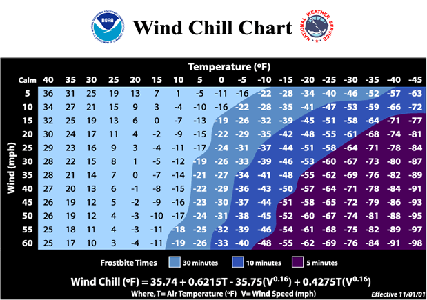
The formula for wind chill is based on advanced computer modeling analysis of winter winds and temperatures, and is so accurate, according to the weather service, that it predicts the "feels-like" temperature based on the calculated wind speed at five feet off the ground — the average height of an adult face.
Even skin tissue resistance, affecting how cold air feels on our hands, is taken into account, the weather service says. The index also is based on heat transfer theory, or heat loss from the body to its surroundings.
Louisville can expect temperatures in the single digits and teens from Monday to Wednesday with an average wind chill of -6 degrees, according to the latest forecast.
Kentucky severe weather outlook
Kentucky Power Outage Map
https://data.lansingstatejournal.com/national-power-outage-map-tracker/area/michigan/26/
Is your power out? Here's how to check the status of LG&E, KU, ODP in Louisville
Ana Rocío Álvarez Bríñez contributed to this report.
This article originally appeared on Louisville Courier Journal: Louisville winter weather: How wind chill is calculated
