Subtropical Storm Nicole expected to reach hurricane strength before Florida landfall
Towering waves, swollen tides and damaging winds will assail Florida’s east coast this week as a corpulent Subtropical Storm Nicole slowly musters power on a collision course with the peninsula.
The National Hurricane Center is forecasting Nicole to be a high-end tropical storm Wednesday as it approaches the northwest Bahamas. It is forecast to gain hurricane strength before reaching coastal Florida late Wednesday into Thursday with 75-mph sustained winds and gusts to 90 mph.
An official forecast as of 4 p.m. Monday had a yawning area of the coast from Homestead through Jacksonville and as far west as the Panhandle's Panama City in Nicole's forecast cone. After an east coast landfall somewhere between Miami and Cape Canaveral, the storm is predicted to turn northwest with Tallahassee, Tampa, and Gainesville also potentially getting wind and rain from the system.
►YOUR COMPLETE HURRICANE STORM GUIDE
Hurricane preparation: What supplies do you need for a storm? Here's a list
Also: Taping windows before a storm? Don't fall for these hurricane myths
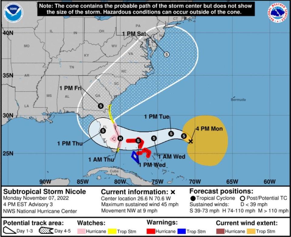
If Nicole crosses the state and reaches the Gulf of Mexico, it could make a second landfall on the Gulf Coast of Florida as a tropical storm.
Nicole is grating against an area of high pressure to its north, creating wind gusts of up to 35 mph before it even reaches the coast.
“People still have time to prepare for this at least through Tuesday evening,” said National Weather Service meteorologist Barry Baxter, who is based in Miami. “Right now, people need to refresh their supplies from Ian and prep for this one.”
National Hurricane Center Acting Director Jamie Rhome said Nicole is not expected to rapidly intensify or gain the virility of a major hurricane of Category 3 or higher. Rapid intensification is when wind speeds increase by 35 mph in 24 hours or less. When that happens near the coast, as it did with Hurricane Ian last month, the results can be devastating.
“This is not a Hurricane Ian situation,” Rhome said. “We are not forecasting a major hurricane or rapid intensification.”
The center issued a hurricane warning for the northwestern Bahamas on Monday. A hurricane watch was issued for the east coast of Florida from the Volusia/Brevard county line through Hallandale Beach and including Lake Okeechobee. A tropical storm watch was issued for the east coast from Volusia County north to Altamaha Sound, and for Hallandale Beach to north of Ocean Reef.
Storm surge watches in effect for entire east coast of Florida
Storm surge watches were also in effect for the entire east coast of Florida. Hallandale Beach south to Ocean Reef could see 1 to 2 feet of surge. Central and southern Palm Beach County could experience 2 to 4 feet, and 3 to 5 feet is forecast for northern Palm Beach County through the Space Coast and into Georgia.
Sustained tropical storm-force winds are expected to reach Palm Beach County and the Treasure Coast by Wednesday evening.
Gov. Ron DeSantis declared a state of emergency Monday for 34 counties including Palm Beach, Broward, Miami-Dade, Martin and St. Lucie.
What's remarkable about the surge from #Nicole is the length of coastline that will be affected, from south of Miami to coastal Georgia. https://t.co/vghLLw4cp5
— Andrew Freedman (@afreedma) November 7, 2022
Nicole’s large size — tropical storm-force winds extended from the storm center’s up to 275 miles — will keep it from organizing quickly, Rhome said.
“When it gets over Florida, it will cover a large portion of the Peninsula,” he said. “Keep in mind some (coastal) areas were impacted by Ian so the dunes have been eroded and the potential for coastal flooding, possibly life-threatening flooding, is possible.”
Nicole's size means bigger waves, beach erosion and flooding
While the storm’s size may inhibit strengthening, it will increase wave heights, beach erosion and flooding. A wide swath of strong winds blowing over an ample fetch of the western Atlantic is what’s going to cause days of gnawing waves that will be exacerbated by higher-than-normal high tides caused by Tuesday’s full moon.
NHC called the storm surge potentially "dangerous" and said it will be accompanied by large and damaging waves.
Still, the east coast is not as vulnerable to storm surge flooding as the Gulf Coast because of the bathymetry — the underwater depth of water — of the coastline. Where the Gulf Coast has more than 100 miles of shallow continental shelf for waves to push up like walking to the shallow end of a pool, the east coast has a steep drop-off, giving water an escape to plunge deeper at the coast rather than pile up and rush inland.
“It takes a significant effort in regard to the run-up of waves on the east coast,” said South Florida Water Management District senior meteorologist Todd Kimberlain. “But 3 feet of storm surge, with the water moving, that is certainly enough to take someone off their feet and those are dangerous conditions.”
Florida emergency managers evacuate residents based on storm surge heights.
As of 5 p.m. Monday, no decisions had been made about evacuations or shelters opening in Palm Beach County.
“Just as the county is doing, residents should continue to monitor this storm closely and be prepared to initiate personal protective measures due to potential impacts,” said Palm Beach County Emergency Manager Mary Blakeney.
Lake Okeechobee stood at 15.89 feet above sea level Monday. The Army Corps, which oversees releasing water from the lake, said there were no risks to the Herbert Hoover Dike based on Monday's forecast.
Kimberlain said the fall's king tides will make draining streets more difficult, especially if Nicole brings heavy rains. Rainfall forecasts for Palm Beach County through Daytona Beach are 4 to 6 inches through early Saturday. Deeper inland, rainfall accumulations are expected to reach 2 to 4 inches.
"The district is going to be looking for every opportunity to release water," Kimberlain said. "That may be difficult even during low tide."
Nicole is expected to transition to a fully tropical storm before Wednesday
Nicole was named early Monday morning, making it the 16th tropical cyclone of the 2022 hurricane season, including two unnamed tropical depressions.
The storm was about 580 miles east of West Palm Beach on Monday afternoon with maximum sustained winds of 45 mph. It was moving northwest at 9 mph.
Nicole is expected to transition to a fully tropical cyclone before Wednesday.
The differences between a subtropical and tropical cyclone are mostly technical. Tropical cyclones draw all their energy from warm ocean water and humid air near its surface, whereas subtropical cyclones get a mixed meal of warm water and other weather-making mechanisms such as upper-level winds or the collision of warm and cold air.
Typically, the wind field on a subtropical storm is wider than a tropical storm. Also, while a tropical storm may have its strongest winds at its center, a subtropical storm can have its strongest winds farther out.
Steering Nicole toward Florida is high pressure to its north. A trough of low pressure will move in Thursday to pick it up and send it north and northeast.
Another disturbance the NHC is watching about 650 miles east of Bermuda and is no threat to the United States. If it gains tropical storm strength, it would be named Martin.
This article originally appeared on Palm Beach Post: Subtropical Storm Nicole to bring storm surge and hurricane-force winds

