How a summer of extreme weather reveals a stunning shift in the way rain falls in America.
Over eight days of wild weather in June, the realities of a changing climate grabbed the nation by its shoulders and shook.
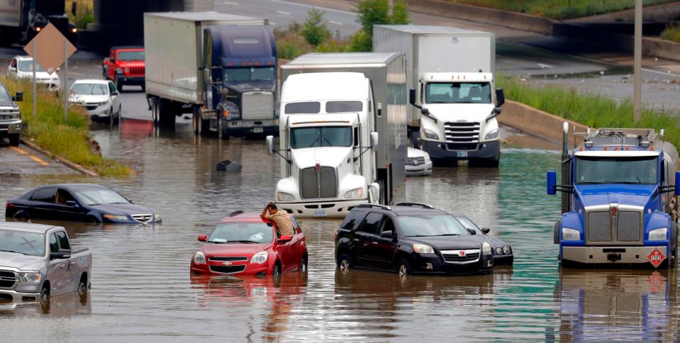
In Michigan, a deluge dropped 7 inches of rain in Detroit, swamping highways and stranding cars.
At least 136 daily rainfall records were set during storms across five states along the Mississippi River.
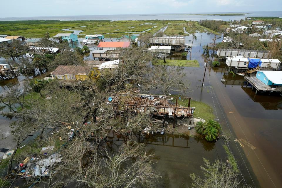
Tropical Storm Claudette soaked a swath of the South, flooding homes in Louisiana and in Alabama, where it dropped up to 8 inches of rain and claimed 14 lives.
Meanwhile, the drought-stricken West grappled with soaring temperatures that shattered century-old records, prompted heat warnings and ultimately killed more than 200 people.
Wildfires exploded in Montana and scorched the earth in California.
Such events do occur naturally, but rarely have so many struck at once or to such an extreme degree, making it hard to ignore their connection to each other and to a warming world.
Rising temperatures and rising oceans have for years been framed as the impending disasters on the crest of climate change. But this year, like few before it, changing rainfall patterns bullied their way into the collective consciousness.
USA TODAY reporters analyzed more than a century of precipitation records from the National Oceanic and Atmospheric Administration and a unique collection of snow and rain extremes computed by Alaska-based climate researcher Brian Brettschneider.
Reporters read thousands of pages of climate assessments, scientific papers, weather reports and government documents. They interviewed more than 70 people, including climate scientists, academic researchers, local and federal officials and residents forced from their homes by drought and flood.
Taken together, the reporting reveals a stunning shift in the way precipitation falls in America.
Heat has changed how moisture moves across the country. Scientists say it alters the flow of the jet stream, extends droughts, and increases evaporation from land and from bodies of water, including the Atlantic and Pacific oceans, the Great Lakes and the Gulf of Mexico.
East of the Rockies, more rain is falling, and it’s coming in more intense bursts. In the West, people are waiting longer to see any rain at all.
Readings from hundreds of rain gauges across the continental U.S. tracked for more than 100 years reveal a noticeable inflection point before the turn of the 21st century.
It marks the beginning of a roughly 30-year increase in the number of extreme downpours and snow falls across the eastern half of the nation.
Of 285 weather stations, 44% get at least one more top rainfall event per year now than they did three decades ago, based on data compiled by Brettschneider. That means what used to count as the top three wettest rainfalls of the year now happen at least four times a year. Most of these increases went beyond what scientists would attribute to chance.
Nineteen places doubled their previous number of days of extreme precipitation – from three a year to six.
Three cities – Roanoke, Virginia; Madison, Wisconsin; and Akron, Ohio – jumped from three days to seven.
In comparison, only 3% of weather stations had a one-day decline in the frequency of the heaviest precipitation events.
As deluges grow in frequency and severity, annual precipitation has increased for more than half the nation. At some point over the past three years, 27 states – all east of the Rocky Mountains – hit their highest 30-year average since record keeping began in 1895, according to a USA TODAY analysis of NOAA data.
A dozen states, including Iowa, Ohio and Rhode Island, saw five of their 10 wettest years in history over the past two decades.
Michigan experienced six since 2008 alone.
At the opposite extreme, eight states – including five in the West – had at least three record-dry years in the same time period. That’s double what would be expected based on historical patterns.
In Sacramento, California, this fall, the city had just ended its longest dry streak in history when it got hit by a late October downpour that topped its previous all-time record rainfall set more than a century ago.
The precipitation was welcomed, but it also spawned at least a dozen rockslides and mudflows in the region.
As states rack up records for rainfall, flooding, droughts and wildfire, it’s becoming clear our country was built for the climate of the past.
Roads, bridges, sewer systems and entire communities that decades ago seemed safe from fire and flood now lie within one or both danger zones.
An October report by the nonprofit First Street Foundation warned that one-fourth of the nation’s "critical infrastructure,” including roads, utilities, airports and emergency services, now faces flood risk from rainfall and sea level rise, as do 1 in 7 residential properties – about 12.4 million homes. Louisiana, Kentucky, Florida and West Virginia are particularly at risk.
Heat, lack of humidity, and wind are combining more frequently to enhance the risk of wildfire. Climate Central, a nonprofit research organization, looked at 17 western states and found parts of New Mexico now have at least 60 additional days when the fire risk is more extreme than 50 years ago.

Parts of 11 other states, including Arizona, California, Colorado, Oregon and Texas, saw more than a 100% increase in these “fire weather days.”
Such calamities displace families, claim lives and leave officials from coast to coast conflicted over which crisis to plan for next and how to pay for it all.
NOAA reported at least 133 “billion-dollar disasters” in the decade ending in 2020, double the previous decade, at a cost of more than $867 billion. Meanwhile, the annual average number of flood claims paid by FEMA also doubled between 1997 and 2020, to 52,000. The cost of the claims was more than eight times higher, at $2.7 billion.
Scientists say it’s too late to stave off some of the climate change-driven precipitation extremes we’re experiencing today. But the nation could take steps to reduce greenhouse gas emissions that amplify the weather extremes and take more aggressive measures to reduce flood risk.
Given the increasing frequency of weather disasters, “one would think the nation might be galvanized to action,” said Rob Moore, a senior policy analyst with the Natural Resources Defense Council. “And yet we are not incorporating what we know about the future into our decisions about what we build, where we build and how we build as a nation.”
What’s causing it?
The earth has always produced erratic weather patterns. But now the heaviest downpours and droughts are growing more extreme. That trend started in the late 20th century, as the accumulation of greenhouse gases like carbon dioxide and methane reached critical levels in the atmosphere.
Climate scientists said these gases trap more of the energy radiating from the planet’s surface, causing the earth to warm.
This warming doesn’t just raise temperatures. It intensifies how water cycles between earth and sky.
Heat hastens evaporation. It draws more water into the air where it gathers into systems that can form wetter storms. For every 1.8 degrees Fahrenheit of warming, 7% more moisture is absorbed, said David Easterling, director of NOAA’s National Climate Assessment Technical Support Unit.
It’s one of the reasons behind many of this summer’s rainiest storms, including Hurricanes Henri and Ida, that flooded communities throughout the South and Northeast this August.
For these storms and others throughout the year, much of their moisture comes from the Gulf of Mexico, Great Lakes and Atlantic Ocean.
Gulf waters alone have warmed about 1.3 degrees over the past four decades. They did so at an average of about a tenth of a degree per decade for most of the last century. Then, in the early 1980s, the rate tripled and hasn’t slowed since.
A warmer Gulf contributes to more rainfall in hurricanes and tropical storms, but its moisture also helps form wetter storms as far north as Wisconsin, Easterling said.
At the same time, some scientists said, rising temperatures have altered the summertime movement of the jet stream that transports moisture across the country. Weather systems that used to hustle along get stalled more often now, dumping more rain in one place.
The jet stream gets its direction and speed from the rotating planet and the way the atmosphere distributes solar energy from the equator toward the poles.
Historically, a sharp difference in temperature between the Arctic and regions to the south kept the stream strong and swift. As the changing climate warms the polar regions faster, the temperature difference lessens in the summer.
Instead of flowing quickly across the north, the jet stream moves slower and gets bigger, wavy dips that trap high and low pressure systems in place, said Michael Mann, a climatologist at Penn State University and author of the book "The New Climate War."
The trapped highs and lows in the summertime affect the weather across the country, Mann said. For example, they can produce extreme heat, drought and wildfires in the West and drop huge amounts of rain to the east at the same time.
“They’re all interconnected to the impact that climate change is having on these persistent weather extremes,” he said. “It’s not a contradiction to have huge floods, unprecedented floods and unprecedented heat waves and droughts at the same time.”
Scientists can’t say for sure how much of the rain in each storm is directly attributed to the changing climate, Brettschneider said, but the shifts become apparent when comparing a sampling of current and older events.
More intense rains
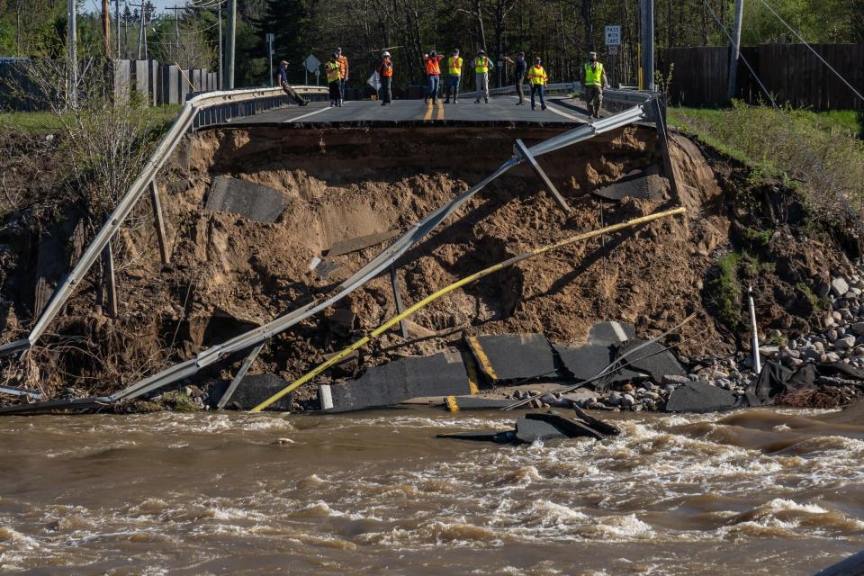
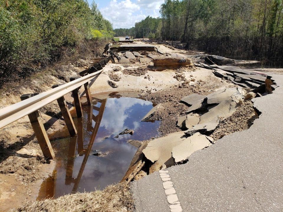
Climate change also has been blamed for fueling the intensity of the storms that unleashed record rainfall and sparked deadly flooding across Tennessee in August.
The day that storm hit started like just another rainy morning in Humphreys County.
Weather forecasters had issued flash flood advisories, warning of 2-4 inches of rain, but no one had predicted four times that much or the catastrophe it would bring.
Typical summer thunderstorms sweep through at 50-60 mph. But on Aug. 21, a system got caught up with a stalled front and traveled through at only 10-15 mph. Meeting up with a pool of Gulf moisture overhead, it forced storms to rain over the area again and again, dropping more than 12 inches of rain in seven hours in the small city of McEwen.
The total rainfall – 17 inches – broke the state’s all-time record and triggered deadly flooding in Waverly.
Tennessee is a state where rainfall totals and the frequency of intense storms have climbed, fueled in part by this same devastating combination of moisture from warming oceans and slower-moving storms.

Bordering the Tennessee River, in the northwestern part of the state, Humphreys County sits in a region that has seen its annual precipitation rise by 1.6 inches in the past few decades.
Joe Duncan recognized the weather was changing there – he said they get less snowfall and “more catastrophic weather” – so when he and his wife moved onto land next door to his mother last year, they studied a flood zone map.
The property, between McEwen and Waverly, lies along Trace Creek, which flows roughly 23 miles westward from its headwaters in the hills around McEwen to the Tennessee River.
What if you could hear climate change? Listen to music based on a century of rainfall data
They placed their home “a little further up hill,” putting the creek about 100 yards behind them. His mother had water up to her garage before but had never flooded. A nearby home built in the early 1900s had never been touched.
All that changed on Aug. 21.
Around 7 a.m., Duncan looked outside and saw water rushing through his yard. He gathered his wife, daughter and two grandchildren and headed out through knee-high water to pick up his mother so they could evacuate. When they reached her house, Duncan turned around just in time to see his mobile home tilt sideways.
By this time, 9 inches of rain had fallen in six hours, sending Trace Creek out of its banks and raging toward Waverly in a muddy torrent.
Calls started lighting up the Humphreys County 911 Center.
“I have a neighbor who’s trapped in her trailer,” one caller reported. “The water’s all around the edge of it and it’s coming up and she can’t get out.”
“I need help,” another caller sobbed. “I am trapped inside my house. I can’t swim and the water is so high. Please help. Please help. Please help.”
The debris-filled Trace Creek hurtled toward a pair of bridges east of Waverly – one for U.S. 70 and one for the railroad. Mayor Buddy Frazier and others believe debris lodged at the bridges, creating a temporary dam until the water crashed through and sent a “tsunami” into Waverly.
See how precipitation has changed in your community
The water spilled across the valley and flooded homes and businesses. Volunteers in helicopters, boats and personal watercraft spread out all along the creek, helping people escape from flooded and collapsing homes.
Duncan’s home slammed against a tree and split into three pieces. He said the nearby home built in the early 1900s also was destroyed.
Twenty people died in the disaster. They’re among 144 flood-related deaths in the nation this year, the second-highest since 1985.
Whiplash between extremes
Rising temperatures also lengthen dry spells, creating wild swings between downpours and droughts.
The length of time between rain or snow storms increased by three days on average across the West from 1976 to 2019, according to research published this year by scientists with the U.S. Department of Agriculture and the University of Arizona.
The researchers also found the longest interval between rains each year increased by 11 days in the West to 32 days across the region. In the desert southwest, it increased by 17 days to 48 days.
Rising temperatures mean the ingredients for storms may come together less often, so it doesn’t rain as frequently, said Russ Schumacher, an extreme rainfall researcher at Colorado State University and state climatologist for Colorado.
Couple that with the lingering high and low pressure systems and it results in exaggerated cycling between wet and dry that can happen from season to season and from year to year.
Even though California’s annual average rainfall isn’t changing that much, the state is experiencing “more rapid flip-flopping from extreme wet to extreme dry,” said Daniel McEvoy, assistant research professor at the Desert Research Institute at the Western Regional Climate Center.
Due to intense atmospheric rivers bringing heavy rain in from the Pacific, the state shifted abruptly from a four-year drought to extreme wet in 2016 and 2017, McEvoy said. It flipped back to dry in 2018, wet in 2019 and then extreme drought in 2021.
Arkansas and Georgia have experienced more swings between record-wet and record-dry years in the past two decades than any other state, according to an analysis of NOAA weather data.
Other regions of the country experience whiplash between extreme rains and drought as well.
Two years ago near Chiefland, Florida, 62 inches of rain fell in less than three months on the Usher Land and Timber farm, just south of the state’s big bend, said Lynetta Usher Griner. It ruined much of the farm’s sorghum crop, used to feed cattle. The next year, the sorghum was harvested five weeks late after 26.5 inches of rain fell in just four days.
“We’re seeing these astronomically large rain events followed by long periods of lack of rainfall, and then we might have another flooding event,” she said.
Either extreme – flooding or extended dry periods – harms farm operations, causing costs to skyrocket, she said. “It’s really obvious to us that things are changing.”
More dry days and drought
While increasingly intense rains fall east of the Rockies, the West experiences intense drought. Rising temperatures and lingering high pressure systems zap greater moisture from soils and plants.
“With precipitation you're only getting half of the picture,” said Daniel Swain, a climate scientist at UCLA and the National Center for Atmospheric Research. “When it comes to drought, temperature is increasingly important and temperatures are rising a lot.”
Together, the intense heat and longer intervals between rains contribute to the conditions creating more record-breaking wildfires in the West.
All but two of California’s 20 largest wildfires in history have happened since 2003, including the August Complex fire that burned more than 1 million acres and destroyed 935 structures, according to the California Department of Forestry and Fire Protection.
Wildfires have raged recently across Arizona, Colorado, Oregon, Montana, and Washington. Oregon had one of its most destructive wildfire seasons on record last year with roughly 2,200 fires that burned more than 1.1 million acres and destroyed more than 4,000 homes.
One of those homes belonged to the Flores family, who lived in the Coleman Creek Estates mobile home park near Medford in the southern part of the state.
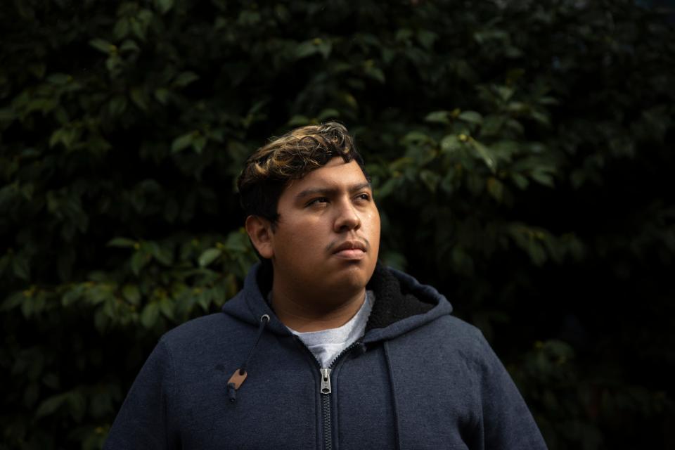
Seventeen years old at the time, Julio Bryan Flores woke up the morning of Sept. 8, 2020, looking forward to celebrating his mother’s birthday when a neighbor's call alerted the family to danger, he said.
“‘You should come outside and look at the sky,’” Bryan remembered the neighbor saying. “It was smoky and dark.”
Soon ash fell from the sky. The entire neighborhood evacuated. Bryan’s father, who had been away, returned home just in time to get the dog, but not his mechanics tools.
“We could see fires literally starting everywhere,” Bryan said. “We were surrounded by them.”
The family escaped, but the fire destroyed their home and possessions. In total, the Almeda fire torched more than 2,600 structures in Talent, Ashland, Phoenix and Medford. When Bryan and his dad returned a week after the fire, “it was a nightmare.”
“There were just the colors white and black everywhere, burned bicycles, destroyed cars, toys left on the street, just burned,” Bryan said. “As we walked toward our house, it was just gone, nothing. … My dad’s tool box was there but every tool melted.”
Once an intense wildfire burns through an area, it leaves the soil hardened and scarred and weakens its ability to absorb water. So when the rains come, they turn dry creek beds into raging rivers, like the one that swept up a Prius near Flagstaff, Arizona, in August, and carried it down the street in a viral video.
The atmospheric river that swept across the West in late October dropped anywhere from 3 to 13 inches of rain across California, Oregon and Nevada.
Though flooding may get less attention in the West, it’s still a big concern, especially in the mountains, said McEvoy, at the Desert Research Institute. When precipitation that used to fall as snow arrives as rain instead because it’s warmer, it can lead to additional flooding.
Researchers are trying to understand the long-term impacts of the change from snow to rain at higher elevations. McEvoy said changes to the snowpack and increased runoff can further harm the region’s crucial water resources.
Action needed now
Critical steps are needed – and soon – to try to keep downpours from growing ever more intense, correct past mistakes and adapt our surroundings to the new reality, experts said.
Many call for sweeping changes to curtail warming, upgrade stormwater and utility systems, and revamp federal guidelines and standards and stop building in vulnerable places.
It’s too late to stave off some of the climate change-driven precipitation extremes we’re experiencing today. The die was cast decades ago. But, they said, the world must reduce the greenhouse gas emissions that, if left unchecked, will continue to heat the planet and further amplify the weather extremes.
“The future is still in our hands,” said Mann.


The earth’s overall temperature is on track to surpass a 1.5 degree Celsius temperature gain above pre-industrial levels unless humans act now to reduce greenhouse gas, warned an August report by the United Nations Intergovernmental Panel on Climate Change. Within 20 years, the goal could be beyond reach.
If we fail, the report stated, the planet will lose more polar ice during the summers and make weather even more extreme.
Scientists don’t know the extent to which extreme downpours could increase, said Ken Kunkel, a research professor at North Carolina State University.
A 4- to 5-degree increase in warming by 2100 could increase rainfall 15%-20%, Kunkel said. That would include some of the rainfall increases already realized. Higher emissions scenarios could increase temperatures another 8 to 10 degrees, and that could mean up to a 30% increase in extreme rainfall rates, he said. “Hopefully we won’t get to that point.”
Only a few places around the world aren’t forecast to get increases in precipitation, said Angeline Pendergrass, an assistant professor of atmospheric science at Cornell University. In the mainland United States, that includes only a small area in Southern California.
Two things appear to be true for “pretty much everywhere that’s populated and on land,” Swain said. “Everyone is getting warmer and everyone is seeing, or should see shortly, more intense precipitation events.”
That’s why the nation must shore up the infrastructure that wasn’t built for the increasing rain and storm events, experts said. Years of neglect and poorly planned development created a recipe for calamity.
Many stormwater, sewage and drinking water pipes are 50-100 years old and nearing the end of their life expectancy, said Christine Kirchhoff, an associate professor in civil and environmental engineering at the University of Connecticut. That leaves communities increasingly vulnerable.
The pipes keep the nation humming, carrying clean drinking water, redirecting water off roads, and hauling away wastewater. When they stop working, Kirchhoff said, either because they’re overwhelmed or the power goes out or both, problems pile up fast.

Often, the burden is heavier on people of color and lower income communities, said Robert Bullard, a professor at Texas Southern University and co-chair of the National Black Environmental Justice Network.
Multiple studies find that people below the poverty level are more likely to live at lower elevations and in flood zones. Harriet Festing with Anthropocene Alliance, an environmental justice group, said chronically underfunded communities are increasingly likely to flood more often and to have a more difficult time recovering.
Floods also prompt massive releases of treated and untreated wastewater into waterways. No one source reliably tracks all the nation’s wastewater releases.
Such polluted discharges threaten human health and promote harmful algal blooms. Several studies have shown evidence of an association between the overflows and increased emergency room visits for gastrointestinal issues.
Part of the problem is the nation’s woefully outdated federal precipitation estimates and inadequate flood zone mapping, said Moore of the Natural Resources Defense Council. Neither takes into account recent rainfall increases, much less future projections.
“We’re still designing highways and stormwater systems and siting people’s homes without any consideration of what the weather is going to look like in 30, 40 or 50 years,” Moore said.
The problems with the information FEMA uses to determine flood risk and the precipitation estimates by NOAA are similar, Moore and others said.
Changing rainfall amounts and rising sea levels mean the estimates, such as a 1-in-100 year flood or a 1-in-25 year rainfall, just aren’t the same as they used to be. Neither set of estimates takes future projections into account.
The NOAA estimates guide governments, engineers and others when designing infrastructure. A new generation of estimates, called Atlas 14, began in 2002, but has never been completed for the entire country. Experts said estimates now used in Idaho, Montana, Oregon, Washington and Wyoming were put together in the 1970s.
When the NOAA data for Texas was updated in 2018 from their earlier 1970s-era estimates, a 100-year storm had become a 25-year storm, said Chad Berginnis, executive director of the Association of Floodplain Managers.
One study showed that for Michigan, Wisconsin, Iowa and Minnesota, the historic estimate of a 1-in-100-year storm is now a 1-in-40-year storm, said Daniel Wright, an assistant professor of civil and environmental engineering at University of Wisconsin-Madison. “These sorts of storms are happening 2½ times as often as they should be.”
Labeling storms as a once-in-a-generation occurrence gives people the impression they can’t have another, said Peter Schultz, vice president of climate adaptation and resilience for ICF, an international climate change consulting firm.
But that’s not accurate.
“If you have dice and you roll a three, that doesn’t mean the next time you roll the dice you can’t get a three. You absolutely can,” he said. “Nature is still rolling the dice, but it’s not fair dice anymore. It’s dice that are coming out toward those higher numbers.”
More in this series
How a summer of extreme weather reveals a stunning shift in the way rain falls in America.
What if you could hear climate change? Listen to music based on a century of rainfall data
Climate change brings a perfect storm of raw sewage and rainfall in cities that can least afford it
Deadly mudslides threaten more Americans as heavy rains loom over scorched lands
Excess fertilizer washed from Midwestern fields is slowly poisoning the Gulf of Mexico
See how precipitation has changed in your community
This article originally appeared on USA TODAY: Rainfall extremes bring massive flooding, downpours, even droughts

