Before summer moves in, read AccuWeather's US summer forecast


Summer weather will waste no time arriving in the United States this year, and while some are counting down the days until they spend some time in the sun on a warm beach, others may be hoping that some of the more dangerous weather elements do not end up like a repeat of last year.
The summer of 2020 was one that will not soon be forgotten, not only because of COVID-19, but also because of extreme weather across the country. Phoenix shattered the record for the most 110-degree days in one year, Colorado experienced the four largest wildfires in state history and the Atlantic spawned a record-setting 30 named tropical systems, 11 of which made landfall in the U.S., in a hyperactive hurricane season.
Veteran meteorologist Paul Pastelok, who leads AccuWeather's team of long-range forecasters, has painted a picture of what people can expect across the U.S. this summer, which officially begins at 11:32 p.m. EDT on June 20, 2021.
 |
Flags line the beach in Belmar, N.J on June 28, 2020. AccuWeather forecasters say the best beach weather for the Northeast will arrive later in summer this year. (AP Photo/Wayne Parry) |
Folks from Phoenix to Fort Lauderdale, Florida, have already had a preview of summer warmth this spring, but people in snowy Denver may have been wondering if the flakes will ever stop falling. The Mile High City measured more than 80 inches of snow this season for the first time since the 1983-1984 season -- and more than a foot has piled up in April alone.
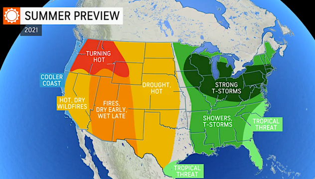
As the nation heads into its second consecutive summer during a global pandemic, signs of normalcy are returning. To find out what summer will be like in your area this year, take a look at the complete region-by-region breakdown below:
The stifling heat of summer may not take hold right away from the Interstate 95 corridor to the shores of the Great Lakes, but that doesn't mean that air conditioners will be able to take it easy this year.
The first part of the summer will feature frequent thunderstorms across the Northeast, Ohio Valley and Midwest, limiting the potential for long-duration heat waves with temperatures averaging right around normal.
AccuWeather's long-range forecasters believe that several rounds of stronger storms could sweep across the region, particularly in June and July, in addition to garden variety summer storms that pop up on warm and humid afternoons.
 |
Lightning strikes over One World Trade Center, center right, during a thunderstorm seen from The Heights neighborhood of Jersey City, N.J., Sunday, June 2, 2013. (AP Photo/Julio Cortez) |
Thunderstorms, while disruptive, will be beneficial for some areas of the Northeast and Midwest where pockets of moderate drought have sprung up in recent months, according to the U.S. Drought Monitor, and were affecting parts of these regions as of late April.
"I think a majority of those pockets will go away by the middle of the summer," Pastelok said.
As the calendar flips from July to August, there will also be a flip in the weather pattern that will open the door for the hottest conditions of the entire summer.
"We could have a dry spell later in the summer that could spark some intense heat for a time," Pastelok said.
 |
All of the major cities along the I-95 corridor of the Northeast are predicted to experience around the same number of 90-degree days as last summer, which is near to slightly above normal. This includes New York City and Philadelphia, both of which experienced a notably higher number of 90-degree days in 2020 compared to normal.
New York City recorded 20 days in 2020 on which the mercury hit 90 F, and Philadelphia managed to crack the 90-degree mark on 36 occasions in 2020. Washington, D.C., may even come close to reaching 90 F on 50 days in 2021.
As a whole, Pastelok said that temperatures may be around 1 to 3 degrees above normal this summer across the Northeast, while temperatures will average close to normal across the Ohio Valley and lower Midwest.
The 2020 Atlantic hurricane season was one for the record books with some communities along the Gulf Coast still recovering following several strikes by powerful storms.
Louisiana was hit particularly hard with multiple landfalling tropical systems, including Hurricane Laura and Hurricane Delta which made landfall just miles away from each other in less than two months' time. Louisiana was pummeled by a record-setting five storms, the most ever to hit the Pelican State in one hurricane season.
This region of the Gulf Coast may get a much-needed break from the tropical weather this year as the highest threat for tropical strikes is likely to focus on other areas of the coast.
 |
Children walk through the mud in Holly Beach, La., amid devastation in the aftermath of Hurricane Laura, Saturday, Aug. 29, 2020. (AP Photo/Gerald Herbert) |
The overall impacts from tropical systems in 2021 is expected to be a bit lower than the past few years, but it is not zero, Pastelok said.
"We do feel there could be a named storm in June, but the way the pattern is setting up in June in the eastern U.S.," Pastelok explained, anything that might develop "may be forced away from the coast or head well down to the south towards Mexico or South Texas."
The other zone where there is an elevated threat for a tropical strike stretches from the Atlantic coast of Florida through the Carolinas.
However, this does not mean that the central Gulf Coast will be completely safe from tropical systems, just that the overall chance of a landfalling tropical storm or hurricane will be lower than it was in 2020, according to AccuWeather forecasters.
 |
AccuWeather |
While not predicted to be as busy as last year, the 2021 Atlantic hurricane season is expected to be another above-average season. AccuWeather is predicting 16 to 20 named storms, 7 to 10 hurricanes and three to five direct hits on the U.S. A typical season features 14 named storms, seven hurricanes and three or four U.S. landfalls.
"Our biggest concern is the fact that water temperatures across the Atlantic are already warmer than normal over a larger part of the basin," said AccuWeather Hurricane Expert Dan Kottlowski, who has been forecasting the tropics for 45 years.
Warm water is one of the key ingredients for tropical cyclone formation, and with the temperatures continually rising throughout the summer, it will translate to more fuel for tropical storms and hurricanes that do develop.
As residents who live along stretches of the Gulf Coast and Atlantic Seaboard will need to prepare for potential impacts from tropical systems, those across the north-central U.S. should brace for an uptick in severe weather events.
The Storm Prediction Center (SPC) reported 253 tornadoes in 2021 as of April 23, below the average of around 400 for late April. However, AccuWeather forecasters believe that a big uptick in tornado activity will occur in May and June.
AccuWeather is predicting between 1,300 and 1,400 twisters by the end of 2021. This is slightly higher than the number of tornadoes in 2020 and right around the average of 1,383, according to SPC data.
CLICK HERE FOR THE FREE ACCUWEATHER APP
"Across the Plains, we're still going to be watching for the possibility of a flare-up of storms, mainly central areas on north during the month of May, June and early July," Pastelok said.
The risk for severe storms and tornadoes will exist a bit farther to the east than normal due to severe drought conditions that stretch from the Texas Panhandle to the border of Montana and the Dakotas.
Drought conditions tend to limit thunderstorm formation due to how dry it is near the ground. This will also lead to a hotter-than-normal summer with temperatures at least 2 to 3 degrees Fahrenheit above average, but Pastelok noted that they could end up much higher.
Because of this, the most active zone for severe weather is predicted to be around Minnesota, Iowa, Illinois, Wisconsin and Missouri. This includes major cities such as Minneapolis, Chicago and St. Louis.
This region may also experience an extreme weather event that is sometimes called an "inland hurricane."
 |
A derecho is a complex of intense thunderstorms that unleashes damaging winds over an area extending hundreds of miles. This type of weather event is nicknamed an "inland hurricane" by meteorologists due to the hurricane-force wind gusts that can often be spawned and the way the clusters of storms can appear on radar. A Category 1 hurricane is classified by a tropical storm with maximum sustained winds of 74 mph or greater.
"We are still very nervous about the possibility of derechos developing based on the pattern that we're forecasting" beginning in early June, Pastelok said.
But not all derechos reach the same magnitude and produce hurricane-force winds. "A derecho must include wind gusts of at least 58 mph or greater along most of its path," according to the Storm Prediction Center (SPC).
One that stands above many of the rest in terms of strength blasted a part of the nation last year. On Aug. 10, 2020, a particularly strong derecho blasted across Iowa with winds greater than 100 mph. The storms leveled entire fields of crops and caused billions of dollars in damages.
Much of the eastern two-thirds of the country experiences a derecho every two years, including a large part of Iowa, and eastern parts of Iowa are impacted by one derecho on average each year, according to the National Weather Service. A large corridor extending from eastern Texas to western Pennsylvania endures a derecho each year on average.
 |
Rod Pierce walks through a cornfield damaged in the derecho in early August 2020, near Woodward, Iowa. Pierce is among hundreds of Iowa farmers who are still puzzling over what to do next following the Aug. 10 derecho, a storm that hit several Midwestern states but was especially devastating in Iowa as it cut west to east through the state's midsection with winds of up to 140 mph. (AP Photo/Charlie Neibergall) |
Complexes of thunderstorms like derechos that take shape in the north-central or midwestern U.S. this summer could potentially travel eastward into the Ohio Valley or mid-Atlantic before fizzling out, according to AccuWeather forecasters.
One of the biggest differences between the summer of 2020 and the summer of 2021 will be evident across the interior Southwest.
"This year, we do feel we see signs that the monsoon will be stronger than last year and will provide enough precipitation to at least help the folks in the short term in the interior Southwest," Pastelok said.
Last summer, the monsoon was virtually non-existent with barely any rain falling across the region. Las Vegas went 240 consecutive days without measurable rainfall (0.01 of an inch or greater), smashing the previous record by nearly 100 days, the National Weather Service said.
Phoenix also experienced an exceptionally dry summer last year, and the lack of clouds and rain from the monsoon propelled the city to break the record for the most 110-degree days in a calendar year. The city tallied 53 days at or above 110 F, blowing past the previous record of 33 days set in 2011. The city is not likely to come close to this record again in 2021 due to the moisture from the monsoon.
Moisture and thunderstorms associated with the monsoon are expected to ramp up in July and last into September, periodically sparking flash flooding and dust storms while also delivering beneficial rainfall to the region.
 |
"Around 45% of the U.S. is under at least minor drought conditions," Pastelok said, with a majority of the interior Southwest experiencing severe, long-term drought conditions. This includes nearly all of Arizona, Utah, Nevada and New Mexico.
Pastelok added that although the monsoon this year will be much more active than last summer, it may be far from one of the wettest on record. It is not likely that enough precipitation will fall to erase the long-lasting drought conditions.
California experienced its third-driest winter in history which has left water reservoir levels well below normal, and with minimal snowpack across the mountains, there will not be much snowmelt to feed the reservoirs throughout the summer.
A drought emergency was issued for several counties in California on April 20 due to drought conditions with the potential for Gov. Gavin Newsom to declare a more widespread drought emergency in the coming months.
Water use restrictions are likely to "come into play during the course of the summer season," Pastelok added.
The parched earth has left vegetation dry ahead of the hot summer, setting the stage for another active wildfire season across California.
Researchers from San Jose State recently found that moisture content levels in vegetation samples were the lowest in a decade.
"We might have bigger fires earlier in the season than we typically would if we had more of a wet year," Craig Clements of San Jose University Fire Weather Research Laboratory told AccuWeather National Reporter Bill Wadell.
 |
Colorado, Utah, Nevada and Northern California will face the highest risk of early summer wildfires before the fire threat shifts as the season progresses.
In 2020, Colorado experienced its four largest wildfires in state history. The Cameron Peak Fire was the biggest, scorching more than 208,000 acres. Previously, the record for the largest wildfire was more than 139,000 acres set in 2020.
Northern California is another area of concern to Pastelok early in the summer with the potential for several significant fires. This is the same part of the state that fell under a lightning siege last summer with lightning bolts sparking several fires that went on to become among the largest in the state's history.
This includes the August Complex fire, which initially consisted of dozens of small fires sparked by lightning that eventually grew and merged into one large firestorm that engulfed more than 1 million acres.
 |
In this Aug. 20, 2020, file photo, a forest burns as the CZU August Lightning Complex Fire advances in Bonny Doon, Calif. (AP Photo/Marcio Jose Sanchez, File) |
Although the winter and spring were not nearly as dry across the Pacific Northwest as it was across California, the hot and dry summer weather will lead to an elevated wildfire risk across the region as well.
The fire danger across Nevada, California, southern Oregon and southern Montana is of particular concern to Pastelok later in the summer and into early autumn.
Pastelok warned that people should "be prepared" for a potentially intense fire season. This includes brushing up on a few simple tips that could make a big difference if a fire approaches.
Editor's Note: Additional information on what constitutes a derecho and the average frequency with which derechos hit the middle of the nation was added to this story for further context.
Keep checking back on AccuWeather.com and stay tuned to the AccuWeather Network on DirecTV, Frontier, Spectrum, FuboTV, Philo, and Verizon Fios.
