'It's super easy.' Scientists studying eroding Sandwich beach want more beachgoers to help
SANDWICH — As teal green waves clambered ashore Wednesday morning at Town Neck Beach, clawing at what little beach there was just past the day's highest tide, graduate student Rilee Thomas went to work.
Thomas, in a combined program of Massachusetts Institute of Technology and Woods Hole Oceanographic Institution, placed her cell phone in a metal support affixed to the railing at the end of a boardwalk overlooking Cape Cod Bay. She snapped two photos of the coastline, first looking eastward, then westward, scanned a QR code printed on the support, and uploaded her images to an online data bank that monitors changes to the shore over time.
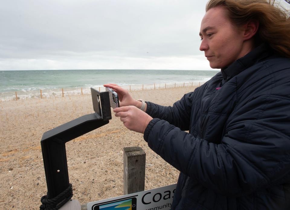
"That was easy!" she said when she was finished, turning her phone to show the message confirming she successfully submitted the photos.
You too can share your coastal photos with scientists
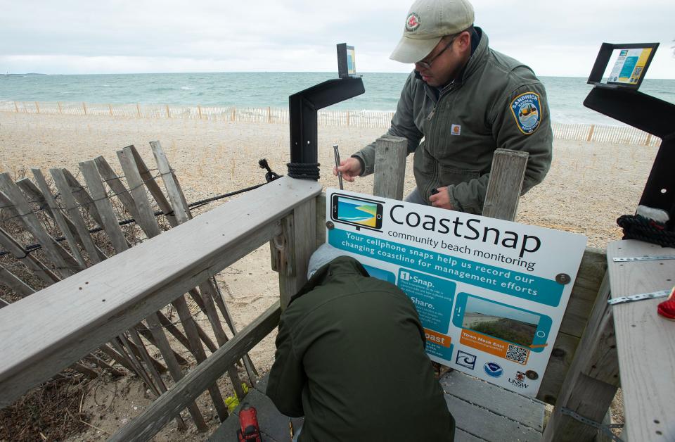
Thomas was among the first to take advantage of a new integration of the WHOI Sea Grant CoastSnap station at Town Neck Beach and the MyCoast MA website. MyCoast MA is a software portal used by the Massachusetts Coastal Zone Management office to collect and share photos and observations of coastal flooding, storm impacts, and shoreline change. The photos and observations are intended to guide policy.
With the help of the Sandwich Department of Natural Resources, the new CoastSnap/MyCoast integration was formally launched on Wednesday, starting with trading the existing CoastSnap sign with a new one offering easy, direct access to the image collection site via QR code.
CoastSnap is a social media-based beach monitoring and outreach tool intended to engage the public in observing coastal change and allow them to participate in documenting it. The initiative was created by researchers at the University of New South Wales in Australia and can now be found in 22 countries around the world.
Cape Cod Cooperative Extension and WHOI Sea Grant coastal resilience specialist Shelly McComb said until now the citizen science project had to rely on people taking photos and then taking the time to upload them and email in or post on Facebook. Then the staff needed to track them manually.
The new process allows that to happen right at the CoastSnap station, in less than a minute. McComb hopes this will lead to more participation in the project, which she admitted has not been as robust as hoped at Town Neck.
"You don't have to even load an app and sign in," she said. "It's super easy."
After trying it out herself on Wednesday, Sarah Das, an associate scientist in geology and geophysics at the Woods Hole Oceanographic Institution, agreed the process is simple and fast.
Monitoring coastal changes
WHOI Sea Grant has been monitoring coastal change at Town Neck since 2020 using images uploaded by citizen scientists through the CoastSnap station, according to Stephanie Murphy, senior communications specialist for the program.

The new integration will help Das and Thomas with their work in evaluating coastal changes resulting from storms, shifting currents and sea-level rise.
"It's kind of a new era for us in terms of photos and access to databases, and that's where Sarah and Riley fit in, in terms of doing the science," Murphy said.
The scientists will work with the images to make quantitative measurements of shoreline changes to complement existing work the town of Sandwich is doing toward coastal resilience at Town Neck.
What happens with each photo?
MyCoast automatically tags geolocation for each photo, links to the NOAA tides and currents databases to show what the tides were doing at the time a photo was taken, provides a snapshot of the weather at the time, and displays the information on a map. It is Thomas' job to develop quantitative analyses based on the collected images and related data.
"We'll collect the photos off of MyCoast and run them through some codes. We have stationary points in the pictures that have GPS tags. From there we can get shoreline positions and see how the shoreline moves," explained Thomas. "You can make time lapses of the beach and can do things like monitor the dunes."
Das noted that Thomas will look at the weather data and correlating it with observed beach conditions "to help us understand what's happening."
She said the goal is "to put science behind that and help with the interpretation of the changes," ultimately "to create more resilient coastlines."
Over time, collected photos will capture beach conditions before and after storms and will be combined into time-lapse videos where change can easily be observed. The videos will be posted to social media and the WHOI Sea Grant website. They will also be shared with communities, coastal and town managers, and researchers.
Town Neck: A rapid-erosion site
McComb said Town Neck is particularly important to monitor to gain insights into the effects of bigger, more frequent storms and sea-level rise owing to climate change.
"This area gets eroded really fast, so it's really important to have this station here to monitor what's going on," she said.
According to information posted on the WHOI Sea Grant CoastSnap page, Town Neck Beach "has been deprived of material from longshore sediment transport by nearby jetties for over 100 years."
"This lack of sand input, combined with rising sea levels, has led to the relatively rapid erosion of this section of shoreline," the site notes. As a result, "shoreline protection for homes needs constant vigilance and without active nourishment the barrier beach would not be able to sustain its current location."
In 2023: Eroded beach and dunes at Town Neck Beach in Sandwich fortified with sand and beach grass
'More eyes and more data'
Das said she and Thomas both like the idea of involving citizens, like crowdsourcing, in helping them do their science and the town to develop resiliency plans. The power of scientists, town officials and citizens working together, she said, "could be enormous."
"The public can provide more eyes and more data to understand the problem," she said.
When people are part of the scientific process, she said, "they feel more invested" in problem solving and developing more of a sense of urgency to prepare for the challenges of climate change rather than simply reacting to them.
Town gets extra credits toward benefiting residents with national flood insurance
McComb said the effort earns the town additional credits toward the Community Rating System, a national FEMA program that offers a discount on premiums for residents who have flood insurance under the National Flood Insurance Program.
Presently, Sandwich is ranked a class 7 community under the rating system, granting residents in this program a 15% discount, according to FEMA.
Other locations also under surveillance
Town Neck isn't the only location being watched. McComb said there is a CoastSnap station on Joseph Sylvia State Beach facing Nantucket Sound on the east side of Martha's Vineyard where a new sign with the integrated program information will be posted.
"In March we're going to be putting one out on Nantucket, on Cisco Beach," she said.
Heather McCarron writes about climate change, environment, energy, science and the natural world. Reach her at hmccarron@capecodonline.com, or follow her on X @HMcCarron_CCT
Thanks to our subscribers, who help make this coverage possible. If you are not a subscriber, please consider supporting quality local journalism with a Cape Cod Times subscription. Here are our subscription plans.
This article originally appeared on Cape Cod Times: Sandwich beachgoers invited to take photos in state coastline plan

