Surge of chilly air could bring the first snowflakes of the season into the South


Chilly air diving into the Southeast through the end of this week will be accompanied by the season's first snowflakes for some areas, causing disruptions ahead of the weekend.
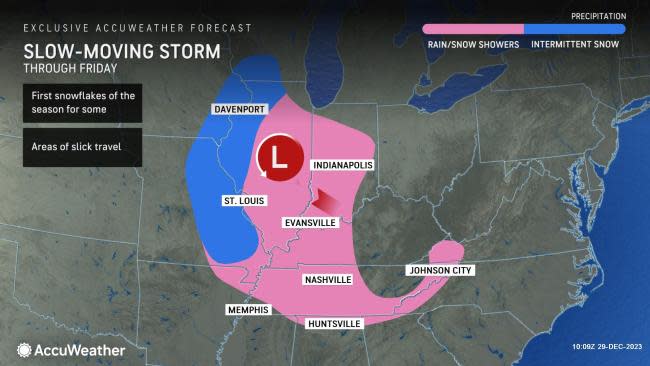
AccuWeather meteorologists have been tracking a powerful storm that has produced an all-out blizzard and a damaging ice storm across portions of the Plains and Upper Midwest in recent days, and the storm won't stop there as wintry conditions shift eastward.
The storm in question will slowly shift out of the Plains and focus rain and snow across the middle Mississippi River Valley, especially around St. Louis, on Friday.
"Snow showers will shift eastward along the I-70 corridor," AccuWeather Meteorologist Andrew Kienzle said. "As the storm moves east, temperatures hovering within a few degrees of freezing could see these showers come as mainly rain limiting snow accumulations across portions of Missouri and Illinois."
A caveat to this mixture or changeover from snow to rain across Missouri will be in any areas where heavier precipitation falls. "Areas of heavy precipitation can lead to rain changing to snow with air above the surface well below freezing," AccuWeather Meteorologist Joe Bauer explained. Kienzle also warned that a slight shift in the storm track could allow a few inches of snow to accumulate around St. Louis.
As temperatures fell Thursday night, motorists along Interstates 44 and 55 across Missouri faced slow travel as a result of wintry conditions. Through the Friday morning commute, places like Cape Girardeau, Missouri, and Paducah, Kentucky, may face a wintry mixture of rain and snow.
The risk of rain and wet snowflakes will not end there, as the storm is expected to crawl into the mid-South to end the week. As the storm does so, multiple cities could be in line to get their first snowflakes of the season.
 |
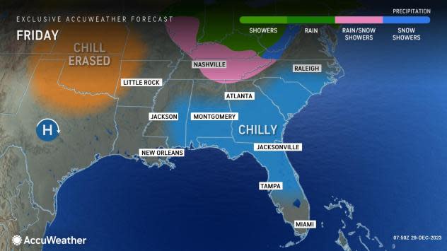
Both Nashville, Tennessee, and Huntsville, Alabama, have not experienced accumulating snow since Dec. 26 of last year, when 0.5 of an inch and 0.6 of an inch of snow fell, respectively. While this incoming storm is not expected to produce heavy snow, there is a chance that a measurable snowfall - defined as 0.1 of an inch or more of snow - could occur into the weekend.
"As a disturbance drops into the storm and as the air turns colder from Friday night to Saturday, snow showers will become more frequent over the southern Appalachians," AccuWeather Senior Meteorologist Alex Sosnowski said. "This is when parts of northern Georgia, eastern Tennessee, western North Carolina, eastern Kentucky, West Virginia and northern and western Virginia stand the best chance of a small accumulation."
 |
This slow-moving swath of wintry conditions will continue to be closely monitored in the days to come. Check back with AccuWeather often for the latest updates on the snow potential in the Southeast.
Want next-level safety, ad-free? Unlock advanced, hyperlocal severe weather alerts when you subscribe to Premium+ on the AccuWeather app. AccuWeather Alerts™ are prompted by our expert meteorologists who monitor and analyze dangerous weather risks 24/7 to keep you and your family safer.
