Surge of warmth to send temperatures to April-like levels in Northeast
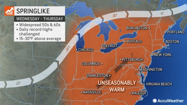
AccuWeather meteorologists say that Northeastern U.S. residents are in for a mild week as temperatures are expected to rise roughly 15-30 degrees above average, peaking in many spots from mid-to-late week. Those yearning for springlike weather may very well get their wish as conditions comparable to late March and April heads their way.
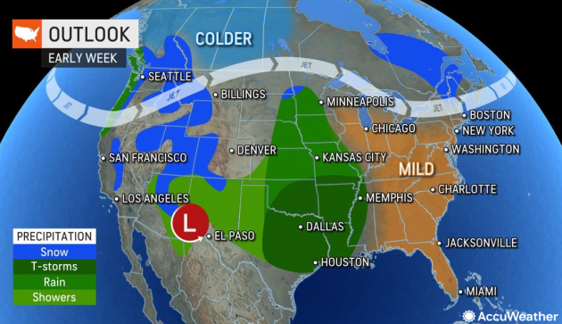
As the week kicks off on Monday, a coastal storm shifting out of the Southeast is expected to spread rainfall to the I-95 corridor. However, some locations will already begin seeing a warming trend on Monday compared to this weekend. Metros such as Philadelphia and New York City are forecast to nudge into the lower to middle 50s Fahrenheit, with warmer days to come by late week.
 |
"As a zone of high pressure builds off the East Coast this week, a surge of warm air will arrive across the Northeast," explained AccuWeather Meteorologist Alex DaSilva.
The jet stream will greatly influence the Northeast temperature trends this week as it pushes northward and ushers in warm air from the South from Wednesday to Friday. Forecasters say that the jet stream will become amplified by Thursday and push northward into parts of southern Canada, allowing max temperatures to climb several degrees above mid-February averages.
"Thursday will be the warmest for many when records can be challenged in many locations. It can even turn breezy by Thursday for many spots, making it feel very much like spring," pointed out DaSilva.
Daytime temperatures in Boston on Thursday can climb to 63 F, which would break the daily record of 60 F set over 100 years ago in 1910. In locations like Providence, Rhode Island, the high could reach up to 60 F on Thursday, which would tie the previous daily record.
 |
Meteorologists are highlighting that even areas across the interior Northeast, such as Albany and Buffalo, New York, and Pittsburgh, can climb within 2-4 degrees of their daily records on Wednesday and Thursday.
The burst of warmth on the way has not been unusual for many Northeast locations this winter. New York City has been running higher than historical averages since the start of the year, departing 9.8 degrees above average for the entire month of January and already climbing to 3.0 above average so far in February. Philadelphia has also followed a similar trend rising to 9.6 degrees above the historical average for January and 4.0 degrees above so far for February.
This year's unseasonable warmth has prompted some to make temperature comparisons between some Southern U.S. cities and select Northeast metro areas. For example, since Jan. 1, the observed average temperature in Philadelphia has been 42.0 degrees F, while the typical average temperature for Charlotte, North Carolina, roughly 450 miles away is around 43.0 degrees F during the same timeframe.
Have the app? Unlock AccuWeather Alerts™ with Premium+
Another notable temperature comparison of temperatures this winter being more typical of southern cities is between Washington, D.C. and Atlanta. Since Jan. 1, Washington, D.C., has observed an average temperature of 44.6 F, while the typical average temperature for Atlanta from January to February is around 45.7 F.
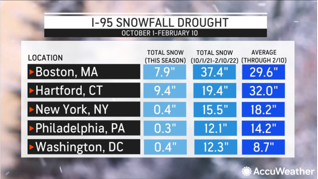
Not only have temperatures trended higher this year, but many key cities along the I-95 corridor have observed below-average snowfall this winter season. Some notable cities on the list include Boston, Hartford, Connecticut, New York City, Washington, D.C. and Philadelphia. The last three on that list have recorded under half an inch so far this season, which is stunning given they typically total between 8-18 inches of snow so far by mid-February.
 |
This winter's lack of snow and stretches of warmer weather reportedly had varying impacts on New England ski resorts. Although storms this season have brought some snow to the higher elevations in New York state, Vermont, New Hampshire and Maine, a few popular resorts were forced to shut down temporarily in early January.
By the end of this week and the start of next weekend, the zone of high pressure influencing the region will be disrupted as the next storm pushes into the Northeast. Many locations will see a noticeable drop in temperature on Friday and even Saturday as this feature spreads rain across the Northeast, and its rear flank pulls cooler air down from Canada as it departs to the east.
AccuWeather forecasters looking further long-term, note that a gradual temperature rebound can occur for many across the Northeast, with temperatures likely to trend above average through the last full week of February.
Want next-level safety, ad-free? Unlock advanced, hyperlocal severe weather alerts when you subscribe to Premium+ on the AccuWeather app. AccuWeather Alerts™ are prompted by our expert meteorologists who monitor and analyze dangerous weather risks 24/7 to keep you and your family safer.
