As Hurricane Watches go up for Big Bend coastal counties, Tallahassee and Leon prepare
5:30 p.m. update:
Hurricane watches have gone up for Big Bend counties as forecasters warn of "life-threatening storm surge and hurricane-force winds along portions of the west coast of Florida and the Florida Panhandle beginning as early as Tuesday."
Here's the National Hurricane Center's 5 p.m. warning:
A Storm Surge Watch has been issued for Chokoloskee to Indian Pass, including Tampa Bay. A Hurricane Watch has been issued for the Gulf coast of Florida from Englewood to Indian Pass, including Tampa Bay.
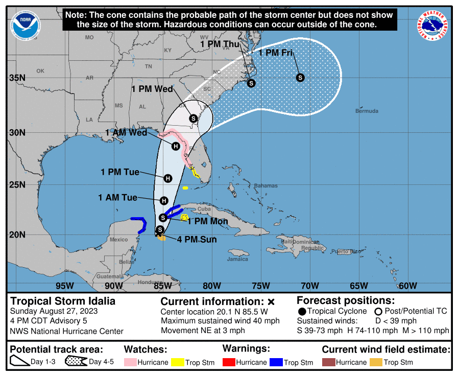
Surge amounts will be exacerbated by high tides from a full moon with forecasters predicting the following. The water could reach the following heights above ground somewhere in the indicated areas if the peak surge occurs at the time of high tide:
Ochlockonee River, FL to Aucilla River: 4-7 ft
Indian Pass, FL to Ochlockonee River: 2-4 ft
Aucilla River, FL to Chassahowitzka: 7-11 ft
The deepest water will occur along the immediate coast in areas of onshore winds, where the surge will be accompanied by large and dangerous waves.
As for rain, portions of the west coast of Florida, the Florida Panhandle, and southern Georgia: From Tuesday into Wednesday, 3 to 6 inches, with isolated higher totals of 10 inches.
Tallahassee and Leon County prepare
The city of Tallahassee and Leon County opened sandbag sites Sunday as Tropical Storm Idalia threatened to strengthen into a hurricane before threatening Florida's Gulf Coast by early in the week.
"Residents are encouraged to prepare now while there is time," the city said in a news release.
County Administrator Vince Long emailed county commissioners just after noon Sunday with an update on storm preparations. The county Emergency Operations Center was in a state of enhanced monitoring and could be at least partially activated as soon as Monday.

"Since Saturday evening, the storm's path has shifted to the east slightly, placing Tallahassee-Leon County on the storm's less severe left or western side," Long wrote. "Over the next week we are forecasted to receive four to eight inches of rain with a low probability of tropical-storm-force winds. Now to be clear, there remains a lot of uncertainty in the forecast, so our impacts may change, but our focus on the storm will not."
City Manager Reese Goad emailed the mayor and city commissioners Sunday afternoon with details on city preparations. The city's EOC was partially activated and the city remained in a state of "operational readiness," he said.
"Though the precise time and location of projected landfall is still uncertain, there is currently a 30-40% chance that Tallahassee will experience sustained tropical storm force winds, with the earliest arrival of those winds anticipated by Tuesday afternoon," Goad wrote. "We anticipate that these probabilities will be adjusted in future updates."
Goad said that Electric Utility field crews have started preparing equipment and stocking materials for storm response. He said the city is communicating with the Florida Municipal Electric Association regarding the need for mutual aid.
In its news release, the city said Electric Utility crews were "ready to be deployed" and that extra staffing and mutual aid with outside line workers were on standby "as needed."
"Uncertainty remains around the exact location or magnitude of impacts, so the region should prepare," the city said. "Historically, local impacts have included sustained high winds and heavy rainfall, which cause downed trees and localized flooding."
Leon County Schools said it has been in contact with principals, Leon County Emergency Management and the National Weather Service as it monitors Idalia.
"As of now, there are no changes to school operations," the district said in an Instagram post. "We will provide updates here throughout the week. Please prepare and stay tuned to city and county updates as well."
County sandbag sites are at the following locations:
Leon County Northeast Branch Library, 5513 Thomasville Road
Apalachee Regional Park (Solid Waste Management Facility), 7550 Apalachee Parkway
Fred George Park, 3043 Capital Circle NW
Oak Ridge Road at Ranchero Road
The county sites are staffed during daylight hours to assist residents with sand, bags and ties available for the public. Residents are asked to take no more than 15 "so as to allow others to prepare," the county said.
City sandbag sites are at the following locations:
Mike Blankenship Skate Park, 2909 Jackson Bluff Road
The former Northwood Centre mall site off Tharpe Street.
The city sites are unstaffed, but sand and bags are provided during daylight hours. Residents are asked to bring their own shovels and limit sandbags to 25 bags per household.
Contact Jeff Burlew at jburlew@tallahassee.com or 850-599-2180.
This article originally appeared on Tallahassee Democrat: Idalia: Hurricane watch for north Florida; Tallahassee, Leon gear up
