Temperature records broken April 12; record or near-record heat possible today
A warm, summery day in northern Wisconsin smashed high-temperature records across the state for April 12, according to the National Weather Service.
The high temperatures Wednesday in Marshfield, Wisconsin Rapids, Wausau, Green Bay and Appleton were 6 to 8 degrees warmer than the previous record, the NWS said.
The warm weather is expected to continue Thursday into Friday, with high temps going up to the low 80s. As a result of the unseasonable weather, combined with a lack of vegetation and strong winds, much of the state remains at an elevated risk for wildfires.
Because of this risk, Gov. Tony Evers declared a state of emergency for Wisconsin Wednesday, which allows the Department of Natural Resources to request support from the National Guard.
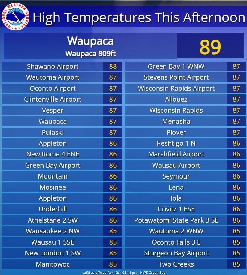
How hot was it Wednesday?
These were the high temperatures recorded April 12 for the following communities:
Appleton: 86
Fond du Lac: 85
Green Bay: 86
Manitowoc: 85
Marshfield: 86
Oconto: 87
Oshkosh: 84
Sheboygan: 85
Stevens Point: 87
Sturgeon Bay: 85
Wausau: 86
Wisconsin Rapids: 87
Many of the previous records were set in 1977. However, Wausau's was 78 degrees in 1930 and Wisconsin Rapids' was 81 in 1941, the NWS said.
The highest temperature in the region on April 12 was recorded in Waupaca at 89. But it's still not the warmest Wisconsin April day ever: that record is 97, which was recorded on April 22, 1980, in Lone Rock.
What's causing the summer-like weather?
A high-pressure system and "upper-level ridge" is causing southerly winds to bring warmer air to Wisconsin, Kruk said.
This pattern is affecting wide swaths of the United States, causing warm, summer-like temperatures in the central Great Lakes region, the southern Great Plains and most of the East Coast.
What impacts do these high temperatures have?
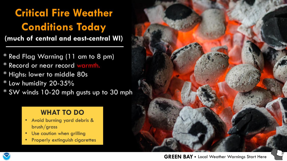
As a result of the warm weather, gusty winds and lack of vegetation, much of the state south of Wausau was under a Red Flag Warning yesterday. During a Red Flag Warning, conditions are ideal for wildfires, which means residents should avoid burning anything outdoors if possible.
Another Red Flag Warning is expected to go into effect from 11 a.m. to 8 p.m. Thursday. The conditions Friday will not be as favorable for fires, with a slightly higher relative humidity and slightly cooler temperatures, said meteorologist Rebecca Kruk.
As a result of the high temperatures, snow is also rapidly melting, causing an elevated risk of flooding for communities along the Wisconsin, Wolf and Menominee rivers. These rivers are at or near flood stage near Portage, Stevens Point, Merrill, Wausau, New London and Shiocton, according to NWS data.
What's the weather forecast for this weekend?
Friday is expected to be another warm and sunny day, with high temperatures again in the high 70s and low 80s. Scattered thunderstorms are possible Saturday, with a rainy day and near-normal temperatures in the 40s and 50s forecast for Saturday.
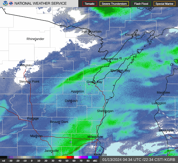
Wisconsin weather radar
Can't see the image? Click here.
Rebecca Loroff is a breaking and trending news reporter for USA TODAY NETWORK-Wisconsin. Contact her at rloroff@gannett.com.
This article originally appeared on Green Bay Press-Gazette: Temperature records broken April 12 in northern and central Wisconsin

