Temperature rollercoaster to send Northeast on a loop


Widespread warmth and mainly dry conditions have built over the Northeast, the start of an extended stretch of mild weather that AccuWeather forecasters say will continue into the final weekend of October with high temperatures in the 70s and 80s. However, the clock is ticking on the warmth as much colder air is building over the northern Rockies and Plains with eyes for the Northeast.
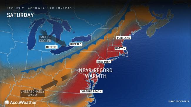
Numerous records will be challenged across the Northeast over the upcoming days, including locations on Long Island, New York, like Islip and LaGuardia International Airport. Even places like Philadelphia, Baltimore and Springfield, Massachusetts, will experience record-challenging temperatures through Saturday.
The last time that Philadelphia recorded a high temperature in the 80s during the last week of October dates back to 1984, nearly 40 years ago. On Friday and Saturday, the City of Brotherly Love is projected to reach and even surpass that mark, which may tie or approach the daily records.
 |
The surge of September-like warmth will be accompanied by some pockets of rain although the showers that do occur into Saturday will be far from a washout.
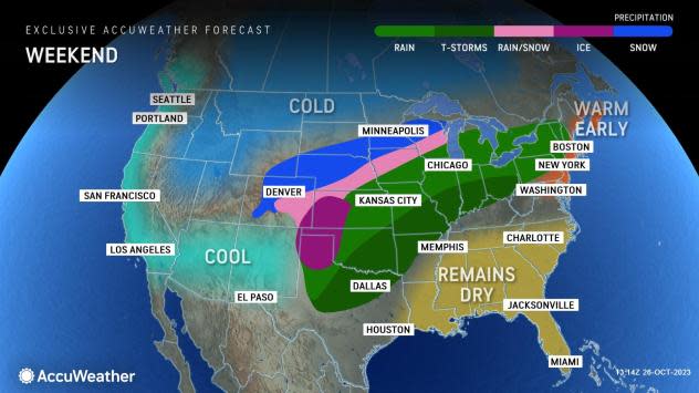
Patches of showers will dampen areas of northern New England, northern and western New York and parts of western Pennsylvania into the Ohio Valley to end the week. Forecasters say that the wet pattern can expand to areas along the mid-Atlantic coast and southern New England by the end of the weekend into early next week.
Residents along the coast are slated to have a nice start to the weekend as the showers largely stay to the north and west. This may turn out to be the warmest weekend until springtime arrives in many locations.
 |
By the end of the weekend, the warmth across the Northeast will begin to fade as a far-reaching storm system featuring rain, thunderstorms and even some snow approaches from the west.
The storm will lose some of its vigor as it tracks east, but the cold air arriving after the storm will not be denied. By early next week, this chilly pattern will shift eastward across the country, and a dramatic temperature drop will be in store for millions of residents across the Central and Eastern states.
Conditions across the Northeast at the start of next week will still feel relatively warm for late October, but this will be the start of a steady temperature decline.
 |
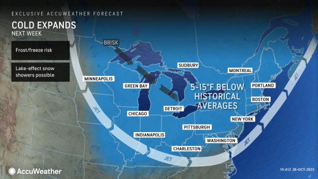
The next chance of a frost or freeze will arrive next week as the cold air filters southward over the Great Lakes, Ohio Valley and New England. A widespread zone from Maine to parts of the Tennessee Valley will contend with low temperatures in the 20s and 30s by Monday night.
By the arrival of Halloween on Tuesday, chilly weather will begin to spread across the region with daytime highs reaching into the 40s across the interior Northeast and in the 50s closer to the coast.
"Across the Great Lakes and Midwest cities, the cold air mass on track to arrive early next week may put an end to the growing season, with many spots like Chicago and Detrott falling a few degrees below the freezing mark," AccuWeather Senior Meteorologist David Dombek said.
Residents in Chicago and Detroit are projected to observe low temperatures dipping down toward 30 and even the 20s by Monday night, with similar conditions expected Tuesday night.
 |
"For many locations spanning from the lower Great Lakes to New England, the temperature values expected overnight next week may prove to be the coldest air of the season so far," stated Dombek.
Places such as New York City and Philadelphia are not expected to have temperatures around the freezing mark next week. However, these locations will still contend with varying temperatures over the next week.
"A roller-coaster pattern of temperatures is not entirely out of the ordinary during October. Most years, a frost or freeze from mid- to late October across the Northeast is a common occurrence," noted Dombek.
In some locations downwind of the Great Lakes, lake-effect snow showers may develop next week as a brisk northwest wind blows across the bodies of water.
AccuWeather meteorologists are also closely monitoring the potential for a potent storm to develop along the leading edge of the coldest air, perhaps resulting in the first snow of the season for some interior Northeast locations and a soaking Halloween for others.
Want next-level safety, ad-free? Unlock advanced, hyperlocal severe weather alerts when you subscribe to Premium+ on the AccuWeather app. AccuWeather Alerts™ are prompted by our expert meteorologists who monitor and analyze dangerous weather risks 24/7 to keep you and your family safer.
