Temperatures plunge in B.C. as Arctic chill infiltrates the coast

Get ready for a big cooldown, British Columbia.
A series of atmospheric rivers wrapped up with a period of damaging winds heading into the start of the weekend. Hundreds of thousands of homes and businesses are still in the dark after winds of 100+ km/h raked the region. In fact, wind gusts at Vancouver International Airport (YVR) were the strongest reported since Remembrance Day in 2011.
RELATED: Windstorm causes 330,000 households to lose power in southwest B.C.
But the blustery conditions aren’t over just yet.
Gusty winds will continue heading into our Sunday, with 40-70 km/h wind gusts possible across the Strait of Georgia during the early-morning hours. The winds will complicate efforts to restore power to those who are still in the dark.

A slow-moving low pressure system from the Pacific Ocean will travel from the coast into southern Interior regions, bringing precipitation from the west to meet a cold air mass from the north on Sunday. Where the two systems meet and stall, a sustained period of snow even down to valley bottoms is forecast.
We’ll also see some off-and-on precipitation across the Lower Mainland throughout the day on Sunday. Most sea-level elevations should remain mostly rain, but even a modest elevation gain could result in heavy, wet snow.
The snow level is sitting at around 300 m this morning across Metro Vancouver. Still, we'll struggle to accumulate much snowfall across the Lower Mainland below 200 m. Higher terrain watch for a period of wet snow later Sunday morning as precipitation rates increase. #BCSnow pic.twitter.com/etJeJvDk8S
The snow level is sitting at around 300 m this morning across Metro Vancouver. Still, we'll struggle to accumulate much snowfall across the Lower Mainland below 200 m. Higher terrain watch for a period of wet snow later Sunday morning as precipitation rates increase. Tyler Hamilton on Twitter: "The snow level is sitting at around 300 m this morning across Metro Vancouver. Still, we'll struggle to accumulate much snowfall across the Lower Mainland below 200 m. Higher terrain watch for a period of wet snow later Sunday morning as precipitation rates increase. #BCSnow pic.twitter.com/etJeJvDk8S / Twitter" Tyler Hamilton on Twitter: "The snow level is sitting at around 300 m this morning across Metro Vancouver. Still, we'll struggle to accumulate much snowfall across the Lower Mainland below 200 m. Higher terrain watch for a period of wet snow later Sunday morning as precipitation rates increase. #BCSnow pic.twitter.com/etJeJvDk8S / Twitter"
Snow levels will drop into Sunday morning as the air mass cools and precipitation intensifies. Locations near sea level may start to see wet snow, but any accumulation will likely be at locations above 100 metres in elevation. Near 5 cm of accumulation is possible in those locations with up to 10 cm over the highest locations over 200 m above sea level.

Snowfall warnings are in effect including for Metro Vancouver, as well as special weather statements.
STAY SAFE: Slippery as ice: Brightly-coloured leaves mask dangerous threat
The big story for B.C. heading into this week will be the unseasonable chill descending on the region. A classic Arctic outflow setup will allow cold air to spill south and keep much of southwestern B.C. much cooler than normal for early November.
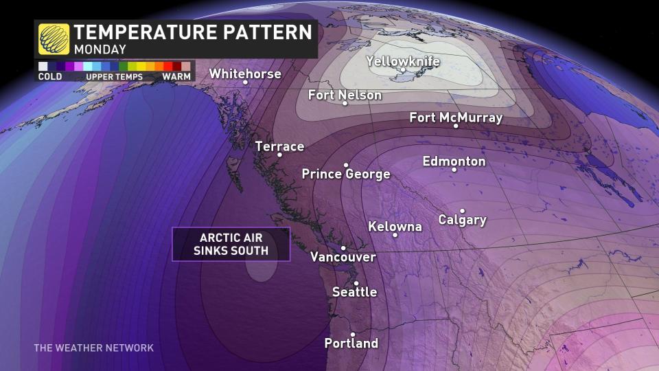
Temperatures will come in 5-7 degrees below seasonal by the beginning of the work week, and the chill will persist straight into next weekend. Vancouver will struggle to climb out of the lower single digits by the middle of the week, and nighttime lows should dip below freezing every night through at least Saturday.
Stay with The Weather Network for the latest on conditions across British Columbia.

