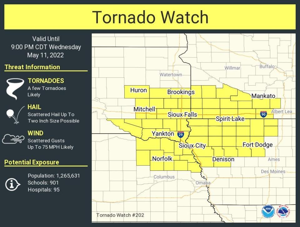
South Dakota removed from tornado watch
Update 5:45 p.m.: The tornado watch has been removed for all of South Dakota.
The watch included the South Dakota cities of Sioux Falls, Yankton, Mitchell, Huron and Brookings.
Earlier story
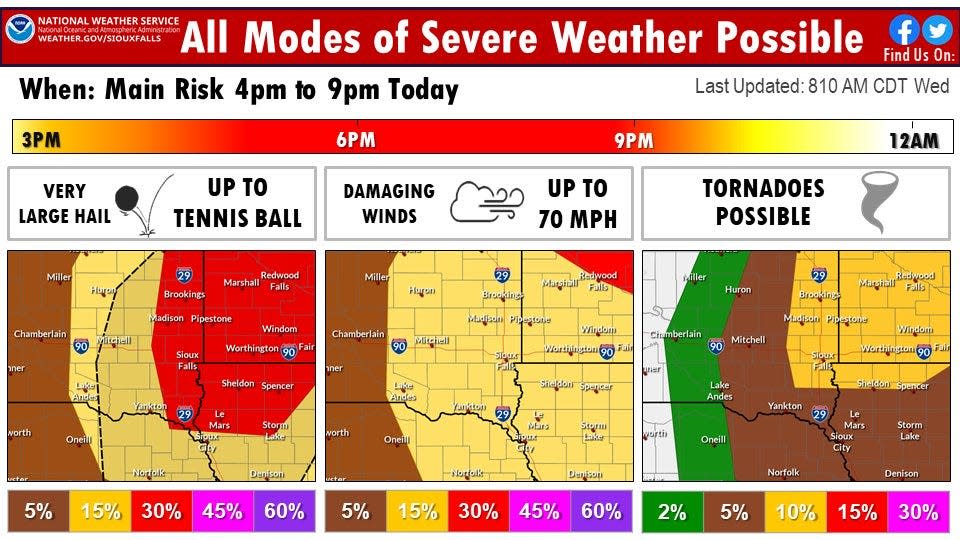
High temperatures this afternoon are expected to usher in severe weather for the region tonight, and all modes of severe weather are possible.
Here's what's expected this evening:
What's the forecast for the Sioux Falls area?
Temperatures will warm up after thunderstorms and rain moved through the area Wednesday morning. The high is projected to be 88 for Sioux Falls.
Later Wednesday afternoon and evening, scattered thunderstorms are expected to develop. Storms would be capable of producing hail up to 2.5 inches in diameter and wind gusts to 70 mph, according to the NWS.
More: NTSB says ice, snow a major factor in Chamberlain plane crash that killed 9; takeoff video released
A tornado will also be possible along and north of I-90. The storms should move northeast of the area by 9 p.m., according to the NWS.
When is the severe weather hitting?
The main risk involving severe weather is from 4 p.m. to 9 p.m. in southeastern South Dakota. Very large hail up to the size of tennis balls are possible, along with damaging winds up to 70 mph and tornadoes, according to the NWS.
Severe weather also possible Thursday
The region isn't done with severe weather after Wednesday night.
More severe storms featuring large hail, strong winds are tornadoes are possible for eastern South Dakota, southwestern Minnesota and northwestern Iowa.
Those storms are expected in the late afternoon and evening.
⚠The severe weather risk today has been upgraded to Enhanced (Level 3 of 5) for areas near/east of I-29. Primary risks are very large hail (up to tennis ball size) & tornadoes.
Another Enhanced Risk on Thursday.
Please stay weather aware & stay tuned for the latest updates! pic.twitter.com/fFmLmzY21w— NWS Sioux Falls (@NWSSiouxFalls) May 11, 2022
A look at the forecast for the days ahead in Sioux Falls, according to the NWS:
Wednesday Night: Showers and thunderstorms likely, mainly before 1 a.m. Some of the storms could be severe and produce heavy rainfall. Partly cloudy, with a low around 69. Breezy, with a south southeast wind 10 to 20 mph, with gusts as high as 30 mph. Chance of precipitation is 60%. New rainfall amounts between a tenth and quarter of an inch, except higher amounts possible in thunderstorms.
Thursday: A chance of showers and thunderstorms after 5 p.m. Some of the storms could be severe. Mostly sunny, with a high near 92. Breezy, with a south southeast wind 15 to 25 mph, with gusts as high as 35 mph. Chance of precipitation is 30%.
Thursday Night: Showers and thunderstorms likely, mainly between 8 p.m. and 2 a.m. Some of the storms could be severe. Mostly cloudy, with a low around 55. Breezy, with a south wind 20 to 25 mph becoming southwest 10 to 15 mph after midnight. Winds could gust as high as 40 mph. Chance of precipitation is 60%.
Friday: Sunny, with a high near 76. West wind around 10 mph.
Friday Night: Mostly clear, with a low around 53. West southwest wind 5 to 10 mph becoming south southeast in the evening.
Saturday: Sunny, with a high near 72.
Saturday Night: Partly cloudy, with a low around 50.
Sunday: Mostly sunny, with a high near 74.
Sunday Night: Mostly clear, with a low around 50.
Monday: Sunny, with a high near 76.
Monday Night: A chance of showers and thunderstorms. Partly cloudy, with a low around 52. Chance of precipitation is 30%.
Tuesday: A chance of showers and thunderstorms. Mostly sunny, with a high near 74. Chance of precipitation is 30%.
Got a story idea from your community? Email reporter Alfonzo Galvan at agalvan@argusleader.com or follow him on Twitter @GalvanReports.
This article originally appeared on Sioux Falls Argus Leader: Tornado watch taken down for southeastern South Dakota, Sioux Falls

