Terrifying Forecast Shows Hurricane Idalia Could Hit Florida TWICE
- Oops!Something went wrong.Please try again later.
As Florida’s gulf coast continues to hunker down ahead of Hurricane Idalia’s arrival Wednesday morning as an “extremely dangerous” storm, those on the state’s Atlantic coast are also being warned to keep an eye on the tropical system this weekend.
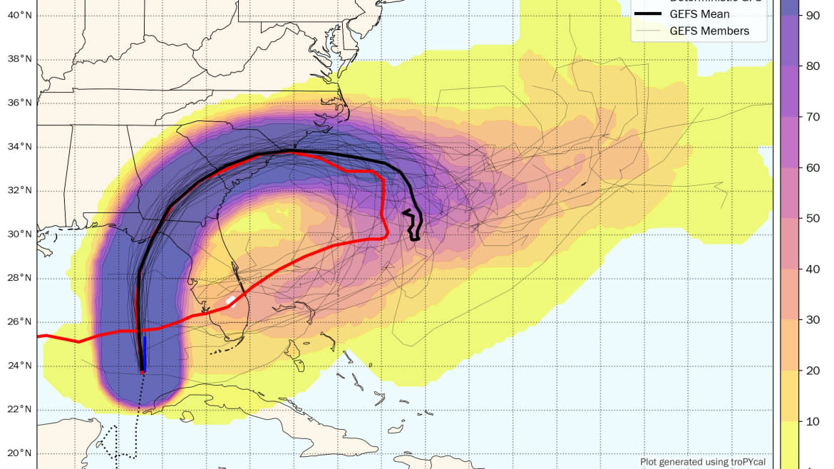
That’s because the Global Forecasting System, a U.S. federal hurricane projection model, predicts the remnants of Hurricane Idalia could circle back and strike Florida a second time early next week.
If Idalia stays true to the GFS forecast, it’d strike Florida’s big bend region on Wednesday morning before traversing across North Florida—where flash flooding, heavy rainfall, and winds in excess of 100 mph are forecasted—and eventually through Georgia and South Carolina, back into the Atlantic.
From there, federal spaghetti models forecast Idalia could take a southwest turn and head back toward Florida’s Atlantic coast for a second landfall in the Sunshine State sometime Monday—albeit after losing much of its original power.
Ummmm... what? #wxx #wxtwitter pic.twitter.com/jPEWQWPrIE
— Pettus Weather (@PettusWX) August 28, 2023
The bizarre scenario is far from a certainty, with outside forecasting models—like the more-trusted European model ECMWF—predicting a different path for Idalia entirely. The looping phenomena of a tropical system is rare, but not unprecedented.
In 2004, Hurricane Ivan made landfall in Alabama—clipping the Florida panhandle—as a major Category 3 hurricane before it traversed across the American South and into the Atlantic Ocean, looping back to make a second landfall with Florida as an extratropical cyclone. From there, it eventually re-entered the Gulf of Mexico and became a tropical storm that delivered heavy rain to Louisiana and Texas more than a week after its initial landfall.
Ivan killed 25 Americans and inflicted a whopping $20.5 billion in damages—inflated by the approximately 120 tornadoes the storm spawned.
Experts fear Idalia, which was upgraded to a Category 2 hurricane Tuesday evening, could be equally dangerous. That’s especially true for Florida’s rural “big bend” region that is particularly vulnerable to flooding because of its “very shallow coastal shelf,” hurricane researcher Phil Klotzbach told The Daily Beast in an email Tuesday.
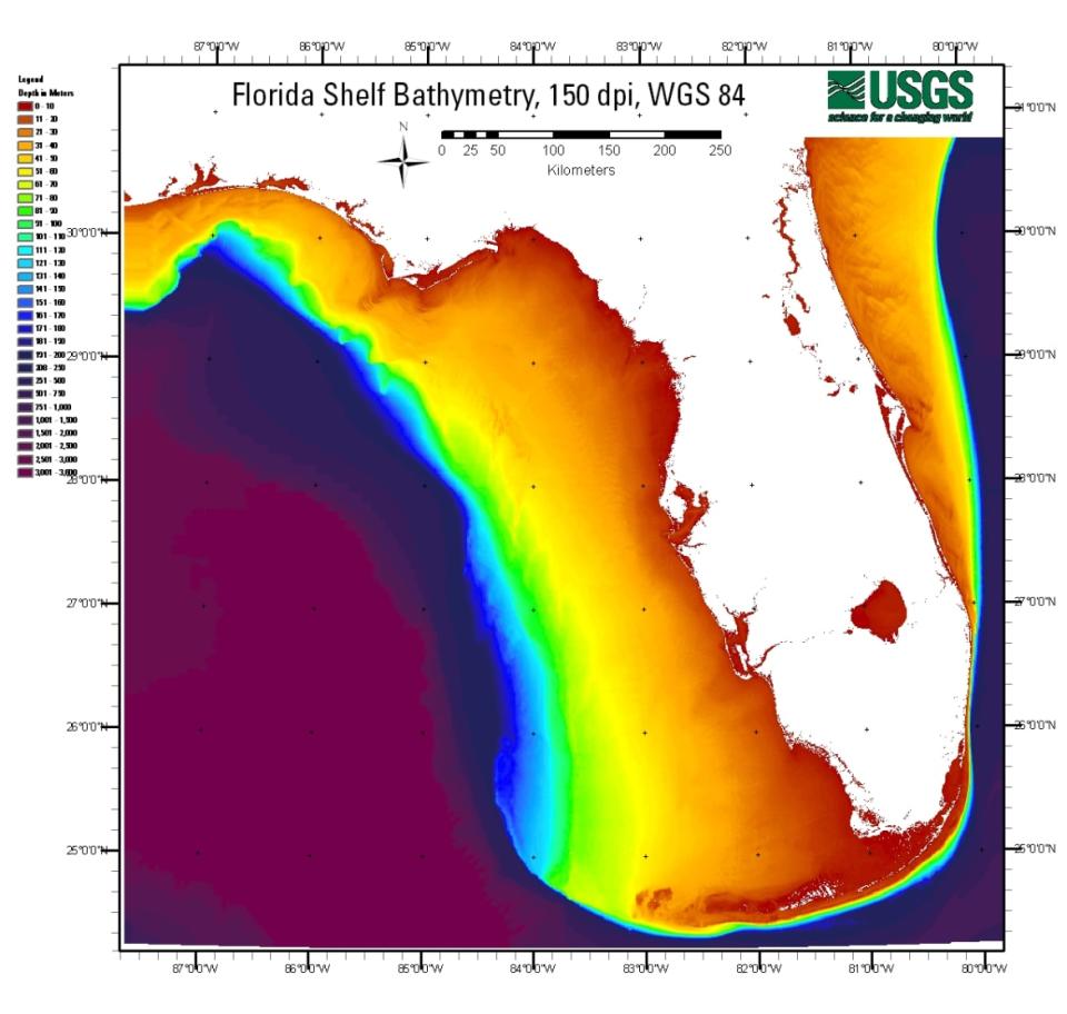
A model showing the depth of Florida’s coastal shelves. Red is considered the most shallow and purple the deepest.
Southern Florida’s gulf coast has an extremely shallow coastal shelf, which Klotzbach says “acts like a ramp for the storm surge”—often the deadliest result of a tropical system. The gulf’s shallow shelf is a stark contrast to Florida’s eastern coast, which has steep coastal shelves that can “reflect some of that storm surge back into the sea” when hurricanes strike, Klotzbach said.
Using data from the National Hurricane Center, some models have projected the historic Florida city of Cedar Key could become entirely inundated on Wednesday in a worst-case scenario, with water toppling over homes and leaving much of the town completely submerged.
The tiny city of 700, which was founded in 1842, could suffer from up to 10 to 15 feet of storm surge. Meteorologists begged the town’s residents to evacuate immediately—and pleaded with dare-devil storm chasers to steer clear of the tourist-friendly area, which is famous for its seafood and “old Florida” vibe.
The National Hurricane Center issues storm surge guidance displaying the 'worst case scenario' surge (i.e., surge that has a 1-in-10 chance of happening)
While this clearly is not guaranteed, it is deeply concerning to see the potential inundation of Cedar Key... pic.twitter.com/vhykg8twBL— Evan Fisher (@EFisherWX) August 29, 2023
“If you’re thinking about chasing in Cedar Key. Don’t,” posted Dylan Federico, a meteorologist at Fox 4 in Dallas.
Craig CeeCee, a Mississippi-based meteorologist, posted a more eerie warning to those who try to ride out Idalia on the key.
“If you’re staying in—or chasing—Cedar Key, think twice,” he wrote. “You are at high risk of being swamped with flood waters higher than homes, and you’ll have no way out. First responders won't be able to help you. If you can get out, do so any way you can.”
As of 5 p.m. Tuesday, the National Hurricane Center forecasts Idalia will make landfall about 50 miles north of Cedar Key around 7 a.m. Wednesday, with winds between 111-129 mph. If it makes landfall as a Category 3 storm as forecasted, it will be the first major storm of the 2023 Atlantic hurricane season to make landfall in the U.S.
Get the Daily Beast's biggest scoops and scandals delivered right to your inbox. Sign up now.
Stay informed and gain unlimited access to the Daily Beast's unmatched reporting. Subscribe now.

