Think it's been hot? You're right. West Palm Beach saw record-setting heat in August
Last month knew no days under 90 degrees in West Palm Beach, ending the meteorological summer as the hottest August in the city’s more than a century of records and with a thirst so deep there is concern for what the dry season will bring.
Anemic afternoon thunderstorms along the coast from Melbourne to Miami and an atmosphere too parched to muster a proper tropical cyclone conspired to hike the preliminary mean temperature for the month to 85.6 degrees as measured at Palm Beach International Airport.
That’s about 2 degrees warmer than normal and enough to beat the previous August heat record of 85 degrees set in 2016, according to the Southeast Regional Climate Center.
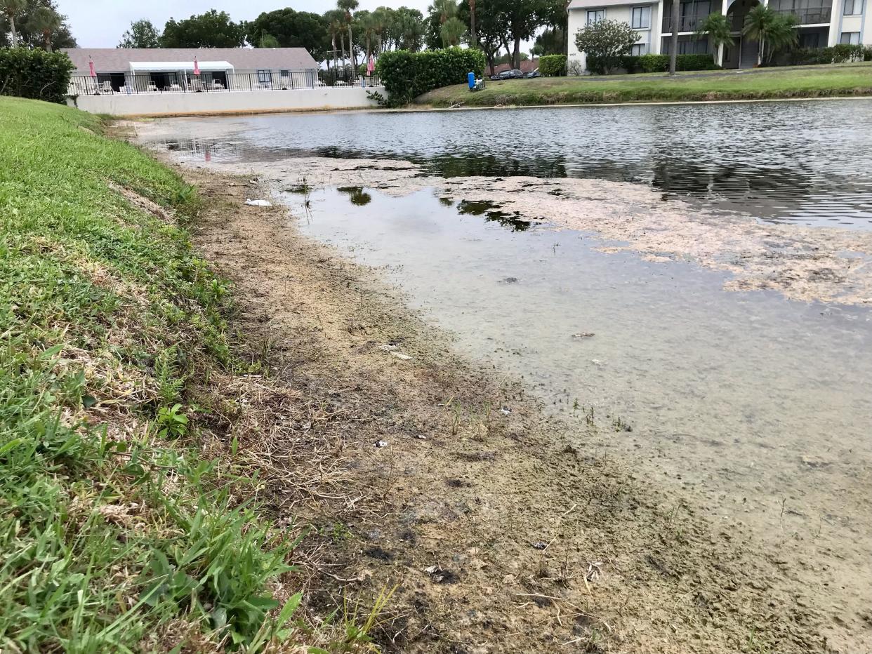
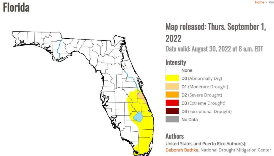
Rainfall for August was just 3 inches at the airport, a deficit of more than 5 inches for the month that pushed all of Palm Beach County to become “abnormally dry” during South Florida’s wet season.
Queen of climate patterns: What a winter shift to the queen of climate patterns means for Florida
Newbies and hurricane season: Hurricane season concerns: Influx of newcomers, COVID variants and supply chain issues
Quiet end to chaos: 2021 hurricane season ends on a whimper, but still busier than normal with one big horror
Florida climatologist David Zierden said he expected the abnormally dry label, which is bestowed by the National Drought Mitigation Center, to spread in the weekly drought monitor report released Thursday. It did, with abnormally dry conditions swallowing all of Broward and Miami-Dade counties also.
Brevard and Indian River counties were listed Thursday as being in a moderate drought — the first level of drought on the monitor’s four-tier scale.
“The nature of our rainy season is that some places get hit and some places get missed. There is a randomness to it,” Zierden said. “The biggest worry is when you get a below-normal wet season and then go through the prolonged dry season. The impacts can really start to show themselves.”
Between June 1 and Aug. 30, West Palm Beach received 14.14 inches of rain, which is an 8.6-inch deficit, but only ranks 21st driest on record.
Southwest Florida saw a mostly normal month for rainfall while Tampa, Vero Beach, Fort Pierce, Fort Lauderdale, Miami and Key West showed deficits.
Areas around Lake Okeechobee and to its north were also abnormally dry, meaning lower flows into the lake left it at 12.58 feet above sea level as of Wednesday.
That’s about 3 inches above something called the water shortage management band, which is a tool used by the South Florida Water Management District to gauge if actions such as water shortage warnings or restrictions are needed. Hitting the management band is not an automatic trigger for restrictions.
The lake was at 14.67 feet above sea level at this time last year.
“Lake O is not rising as it should this time of year,” Zierden said. “It’s something to keep an eye on, but we are still in the wet season.”
Today is the start of Meteorological Fall! What does that mean for us in South Florida?
Essentially nothing, as Sept remains a hot and wet month for our area. Average temps do drop a degree or two relative to August, so I guess we can claim that as our taste of "Fall".#Flwx pic.twitter.com/NuYOnZewNE— NWS Miami (@NWSMiami) September 1, 2022
Subscriber Exclusive: Hurricane Andrew unleashed fury 30 years ago. But since, storms have gotten much worse
A week after Hurricane Michael:Devastating hurricane may signal end of beach town
2018's Hurricane Michael: 'I trust God...but if anyone has a generator, that would be helpful'
The National Weather Service in Miami considers the rainy season to be May 15 through Oct. 15, and just one soggy tropical tantrum could erase the dry conditions. Rains from Hurricane Irma in 2017 helped push the lake up 3 feet in a month to a 12-year high.
No named storms in August but Tropical Storm Danielle could become a Cat 1 hurricane
August was also the first since 1997 that saw no named storms in the Atlantic basin, although Tropical Storm Danielle reared up Thursday 960 miles west of the Azores. It has its sights on becoming a 90-mph Category 1 hurricane, according to the National Hurricane Center, but is moving northeast and is no threat to the U.S.
Danielle is only the fourth named storm of the season, but the NHC is watching two other areas with high and low chances of development. Following Danielle on the 2022 hurricane naming list is Earl and Fiona.
Meteorologists disagreed mildly Wednesday on whether the lack of tropical cyclones and southeastern Florida’s parched conditions were linked.
Several heavy bouts of Saharan dust earlier in the summer helped dry out the atmosphere in the main runway between Africa and the Caribbean where tropical waves often graduate to storms. It also oozed into South Florida, sucking moisture from the air and limiting rainfall.
But another player — the tropical upper tropospheric trough, or TUTT — has also acted to hinder formation with several visiting the central and eastern Atlantic this season.
The troughs have pumped dry, stable air into areas where storms form and created cutting wind shear.
“Tropical waves need moist unstable air, relatively favorable shear, and very warm water,” said Dan Kottlowski, a senior hurricane forecaster for AccuWeather. “We have the warm water, but the dry air and wind shear is working against formation.”
At the same time, Kottlowski said the Bermuda high has been stronger than normal. That has helped southeast Florida’s afternoon sea breezes push farther inland where showers form when they collide with west coast breezes.
“On days with weaker wind flow, the east coast sea breeze stays closer to the coast,” said NWS meteorologist Chuck Caracozza.
A lack of cooling afternoon showers pumped up temperatures, including the top August temperature of 96 degrees measured on the 18th. For the meteorological summer, the mean temperature was 84.8 degrees, making it the fourth-warmest on record.
Meteorologists group seasons by months. Astronomical seasons are based on the tilt of the Earth, with astronomical fall starting Sept. 22 this year.
With about six weeks left in the official rainy season, and the Atlantic basin waking grumpy from a quiet August, it’s also notable that a La Niña climate pattern remains in place — an atmospheric arrangement that is generally more accommodating to hurricanes, but also can lead to drier dry seasons.
“Just because the hurricane season has been less than expected does not diminish the potential for us to be impacted by a major hurricane,” Kottlowski said. “Given the chance to develop with the warm water, you could have a monster storm.”
This article originally appeared on Palm Beach Post: Dry summer in West Palm ends with record-setting heat, bubbling tropics

