A third wave has appeared in the Atlantic, and two are forecast to turn into depressions
A third tropical wave formed in the Atlantic early Wednesday — and while its chances of strengthening as it moves away from Africa remain low, the other two systems are forecast to turn into tropical depressions this week, the National Hurricane Center said.
Wave one, the closest one, is producing disorganized showers, thunderstorms and gusty winds over the eastern Caribbean Sea, according to the National Hurricane Center’s 2 p.m. advisory. Forecasters say the fast-paced system is moving west and is not expected to see any significant developments until it slows and reaches the northwestern Caribbean Sea.
A tropical depression is then likely to form late this week or during the weekend, according to the hurricane center. The wave has a 60% chance of tropical cyclone formation in the next 48 hours and an 80% in the next five days.
The system’s roughly projected path takes it toward the Yucatan Peninsula and well south of Puerto Rico and Cuba.
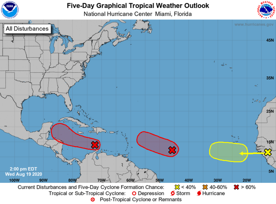
Wave 2 is a little over 1,000 miles east of the Windward Islands and is continuing to produce a concentrated area of showers and thunderstorms, according to the hurricane center.
It has a high 90% chance of forming into a tropical depression in the next two to five days as it moves west-northwest at 15 to 20 mph, forecasters said. It’s too early to tell where or when the storm could go, but forecasters said people in the lesser Antilles should watch the storm.
A third tropical wave has formed in the Atlantic. Where is it going?
As for “vigorous” Wave 3, it is producing a large area of showers and thunderstorms over Guinea, Africa and could see some “marginally conducive” conditions for some development as it enters the “extreme” eastern Atlantic on Friday, according to the hurricane center.
“By early next week, however, conditions are forecast to become less favorable for tropical cyclone formation while it moves west-northwestward at 15 to 20 mph toward the central tropical Atlantic,” according to the advisory.
Forecasters say it has a 0% chance of tropical cyclone formation in the next 48 hours and a 30 percent chance of formation in the next five days.
NOAA has projected the 2020 hurricane season could be one of the most active of all times, with 19 to 25 named storms occurring. So far, there have been 11 named storms, two of which were hurricanes at one point. The next two names on the list are Laura and Marco.

