Thunderstorms could bring strong winds, flooding and hail to Bucks County on Monday
Bucks County can expect severe storms throughout the day Monday, followed by scattered thunderstorms potentially lasting until Wednesday, according to the National Weather Service forecast.
Michael Lee, a meteorologist at the weather service, said risks associated with Monday's forecast, especially those generated by strong winds, are the most dangerous and widespread of the week.
"Folks can prepare for pretty much anything: damaging winds, flash flooding, large hail and yeah, we can't rule out tornadoes either," Lee said Monday morning.
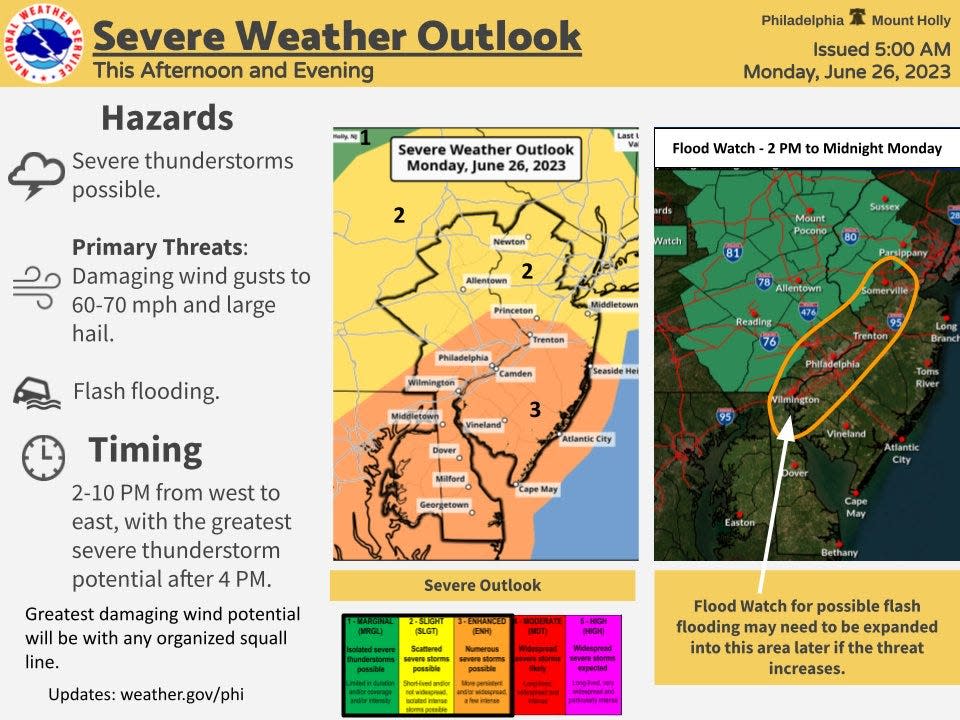
Storms could roll in before 2 p.m. and then continue into the evening.
The region can be on the lookout for strong and damaging wind gusts that could cause issues with powerlines, as well as the potential for large hail. While the tornado risk was low as of Monday morning, Lee said the NWS is still "very concerned" as they continue to track the storm.
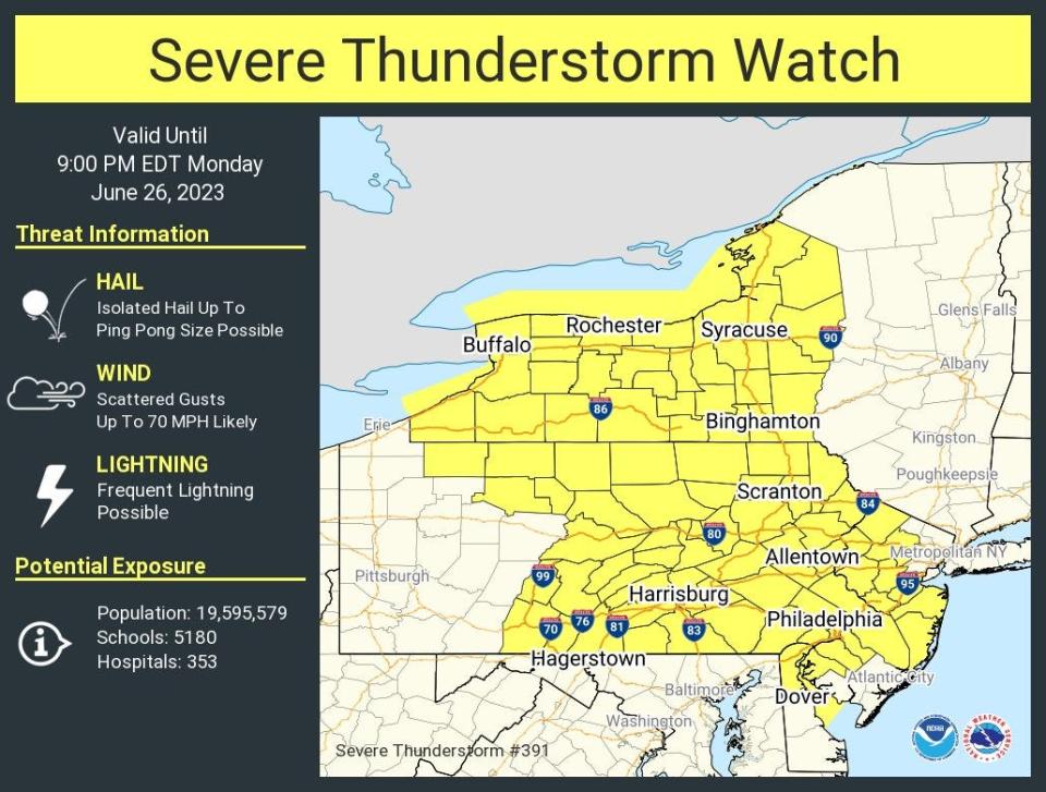
As of Monday afternoon, a flood watch and severe thunderstorm watches were issued for the region through tonight, including Lower Bucks County. The NWS said excessive runoff from heavy rains may lead to flooding in low-lying and flood-prone areas.
🌧️⚡ Flood Watch update: Showers & thunderstorms already underway with more expected later. Expanded coverage to I-95 corridor due to increased potential. Severe weather still likely after 4pm, but early storms already causing sporadic damage. Stay weather-informed today! pic.twitter.com/czAD76gc50
— NWS Mount Holly (@NWS_MountHolly) June 26, 2023
What is causing the severe weather in Bucks County on Monday?
National Weather Service meteorologist Lee Robertson explained that multiple factors are causing the unsettled weather in Bucks County and the region, including a warm front moving across the area mixing with strong atmospheric instability.
"Anytime you get strong instability and strong wind shear, that generally can lead to severe thunderstorms," Robertson said.
Robertson also said there is an upper-level, low pressure system that is moving out of the Great Lakes region and toward the northeastern states. This system can help cause vertical lift for thunderstorms and is sending multiple overload disturbances that can help initiate rain showers and thunderstorms throughout the Northeast.
Stay safe amid thunderstorms in Bucks County
In order to stay safe amidst the storm, Lee advises residents to have multiple ways of receiving weather alerts and bring inside any outdoor furniture or ornaments that could become projectiles in severe winds.
"Things like trampolines, it can be hard to take them down, but certainly do," Lee said. "Those like to fly like a kite."
Lee said that residents in all areas of Bucks County should be prepared for the dangerous weather.
"For today, we want to kind of keep everyone on alert for severe weather," Lee said. "I wouldn't say one place will see more than another. Certainly, someone will, but in terms of what people should prepare for, everyone should prepare to see a potential for severe weather all over."
Bucks County weather this week
The storms that Bucks County will experience Monday will likely continue with less severity Tuesday with thunderstorms also possible on Wednesday, according to the weather service.
Thursday will have the week's nicest weather according to the forecast, with sunny skies and a high near 80 degrees in Bucks County, but there is a 40% chance that rain showers and thunderstorms return over the weekend.
Staff writer Kaitlyn McCormick contributed to this report.
This article originally appeared on Bucks County Courier Times: PA weather: High winds, flooding, hail possible in Bucks County Monday

