Thursday's live updates: Marion County feels effects from Hurricane Ian
Hurricane Ian, packing 155 mph wind, made its official landfall at 3 p.m. Wednesday over Cayo Costa, a barrier island just north of North Captiva Island off the cost of Fort Myers.
It is the exact same place where Hurricane Charley made landfall in August 2004. Charley, also a Category 4 storm, was much smaller than Ian.
Hurricane Ian then began making its way across Florida, toward the east coast.
Check back here during the day for the latest Marion County news
Live updates: Follow the storm throughout the day
Previous coverage: Wednesday's live Hurricane Ian updates in Marion County
Previous coverage: Tuesday's live Hurricane Ian updates in Marion County
7 p.m. | 'We are blessed in our community to only have minor impacts from Hurricane Ian.'
In a statement posted to Facebook Thursday night, County Commission Chairman Carl Zalak thanked the sheriff's office, the county's Emergency Operations Team and the community for all their work through the storm.
"Our thoughts and prayers are with those in Southwest Florida that have been heavily impacted by this storm," he concluded. "We will do everything in our power to support them through this difficult time."
5:15 p.m. | The latest on power outages in Marion County
This was the report as of 5:15 p.m. Thursday:
Provider (Customers): Outages
Central Florida Electric Cooperative (9): 0
Clay Electric Cooperative (16,605): 1,710
Duke Energy (74,536): 2,749
Ocala Electric Utility (52,146): 412
SECO Energy (64,766): 603
Total (208,062): 5,474 (about 2.63% of all customers countywide)
1:55 p.m. | Marion County will help its neighbors to the south
By now many people have seen the devastation that Hurricane Ian caused in Fort Myers and other parts of southwest Florida.
Lee County Hurricane Ian damage: News-Press reporters record the damage in and around Ft. Myers. https://t.co/4WiaggEkS3
— The News-Press (@TheNewsPress) September 29, 2022
The Marion County Sheriff's Office will do its part to help down there.
"The Marion County Sheriff’s Office is currently assembling personnel, equipment, and supplies to dispatch to the Southwest Florida counties who were devastatingly impacted by Hurricane Ian. Our prayers are with those who have lost so much during this difficult time. Further updates about these efforts will be forthcoming as arrangements are finalized," the sheriff's office said in a news release Thursday afternoon.
1:20 p.m. | Emergency operations are winding down in Marion County
At 1:20 p.m., the Marion County Sheriff’s Office Division of Emergency Management announced that the citizen information line is now closed. Also, all emergency shelters began closing at 9 a.m.
"Citizens who have special needs were assisted and officials ensured their homes had functioning utilities and were safe to return to," the division said in a news release.
"We are currently monitoring any additional impacts from Hurricane Ian and working to remove debris, clear roadways and restore utilities," the release says.
12:05 p.m. | The latest on Marion County power outages
This was the report as of noon Thursday:
Provider (Customers): Outages
Central Florida Electric Cooperative (9): 0
Clay Electric Cooperative (16,605): 5,214
Duke Energy (74,536): 4,914
Ocala Electric Utility (52,146): 167
SECO Energy (64,766): 548
Total (208,062): 10,843 (about 5.2% of all customers countywide)
11:20 a.m. | Not a good day for shopping in Marion County
As Hurricane (now Tropical Storm) Ian made its way east on Thursday, many Ocala stores remained closed.


10:15 a.m. | National Weather Service reports initial rainfall totals from Hurricane Ian
Thursday morning, National Weather Service meteorologist Will Corless said rainfall for Marion County within the past 36 hours has been less than predicted.
Corless said the eastern portion of the county recorded 3.46 inches. In Candler, the reading was 2.55 inches. The Villages reported 1.88 inches and in Dunnellon it was 0.64 inches.
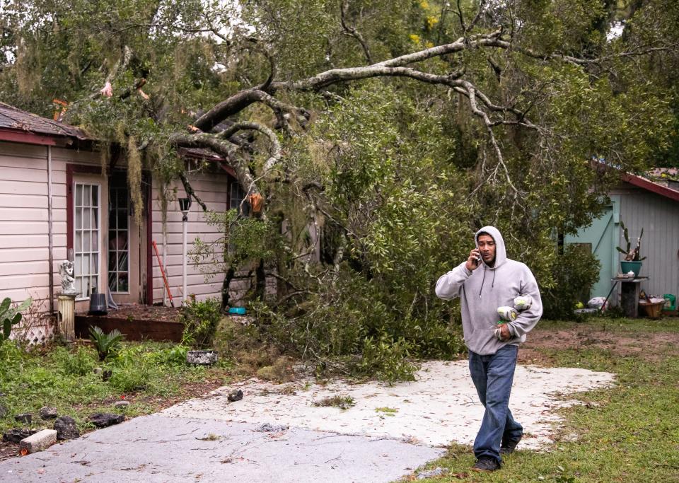
10:05 a.m. | Local agencies begin reporting damage assessments
It's early still, but this is what the Star-Banner has learned so far:
Ocala Fire Rescue spokeswoman Ashley Lopez said shortly after 8:15 p.m. Wednesday, her agency was notified about a tree on a home in the 1600 block of Northwest Third Avenue. No one was injured.
Dunnellon Police Chief Mike McQuaig said a tree fell down on power lines, affecting service for a few customers. Those power lines were on Ohio and Walnut Streets.
Ocala Police Lt. Anthony Vizzini said a tree fell down overnight, affecting power lines. He said officers worked 12-hour shifts monitoring the city.
The Belleview Police Department reports no damage.
10 a.m. | Several hundred people rode out the storm in shelters
Several hundred people did utilize shelters overnight into Thursday morning. Marion County School Board Chairman Eric Cummings shared on Facebook that there were 100 people, and 35 animals, at the pet-friendly shelter at Vanguard High School.
6:20 a.m. As Hurricane Ian leaves the area, cooler weather moves into Marion County
A cold front, which helped push Ian across Florida, has arrived in Marion County. Wednesday's high temperature was only 77 degrees and the low on Thursday dipped below 60 in some locations.
The high temperature each day for most of the next week is not expected to reach 85 degrees, according to the National Weather Service in Jacksonville. Each day will be sunny, except for a partly cloudy Wednesday.
The high temperature in Ocala on Friday is expected to be 76 degrees, with northwest wind of up to 17 mph.
The highs on Saturday through Wednesday are predicted to be about 83 degrees, with lows about 60.
5:55 a.m. | Do you have storm-related questions? The Marion County Sheriff's Office reminds residents that the citizen information line is still being staffed.
5:05 a.m. | Power outages: Updated power outages across Marion County
As of 5 a.m., 6,762 out of 208,049 Marion County customers with five power companies were without power. That means 96.75% of all customers have power at 5 a.m. Thursday.
Provider (Customers): Outages; %Power still on
Central Florida Electric Cooperative (9): 0; 100.0%
Clay Electric Cooperative (16,601): 337; 97.98%
Duke Energy (74,536): 3,069; 95.89%
Ocala Electric Utility (52,146): 3,084; 94.13%
SECO Energy (64,766): 272; 99.59%
Total (208,049): 6,762; 96.75%
5:05 a.m. | National Weather Service says worst of Ian has passed for Marion County
Hurricane Ian continues to skirt far southeastern Marion County Thursday morning and National Weather Service forecasters say no major damage has been reported countywide so far.
Jason Hess, a meteorologist for the National Weather Service in Jacksonville, said the worst of Ian, which is now packing 65 mph as it heads toward Cape Canaveral, has passed for Marion. Ian is now a tropical storm.
When asked about reports of major storm damage so far in Marion, Hess said there have not been any. He said there have been tropical storm wind gusts and some localized rain totals of above 5 inches.
"There was peak wind gusts were 30 to 40 mph," Hess said. "So, that continued shift to the south and east of Marion County may mean the tropical storm warnings and flood watches may fall (or be discontinued)."
Hess said Ocala may get another 1 inch of rain, up to 4 inches in the Ocala National Forest, throughout Thursday. He said the wind will continue to taper off through the evening, with wind speed up to 20 mph and gusts up to 40 mph.
Hess said today's high in Marion County will only hit 73 degrees.
This article originally appeared on Ocala Star-Banner: Hurricane Ian Live Updates: How is Ocala/Marion weathering the storm?

