Palm Coast tornado: What we know and what's the difference between a warning and a watch
Yes, it was a tornado.
An EF-2 tornado with winds between 111 to 135 mph touched down in Palm Coast's B-section early Thursday morning, according to the National Weather Service in Jacksonville.
A tornado watch remained in effect through 3 p.m. Thursday for more than two dozen counties across Florida, including Volusia and Flagler, according to the National Weather Service in Melbourne.
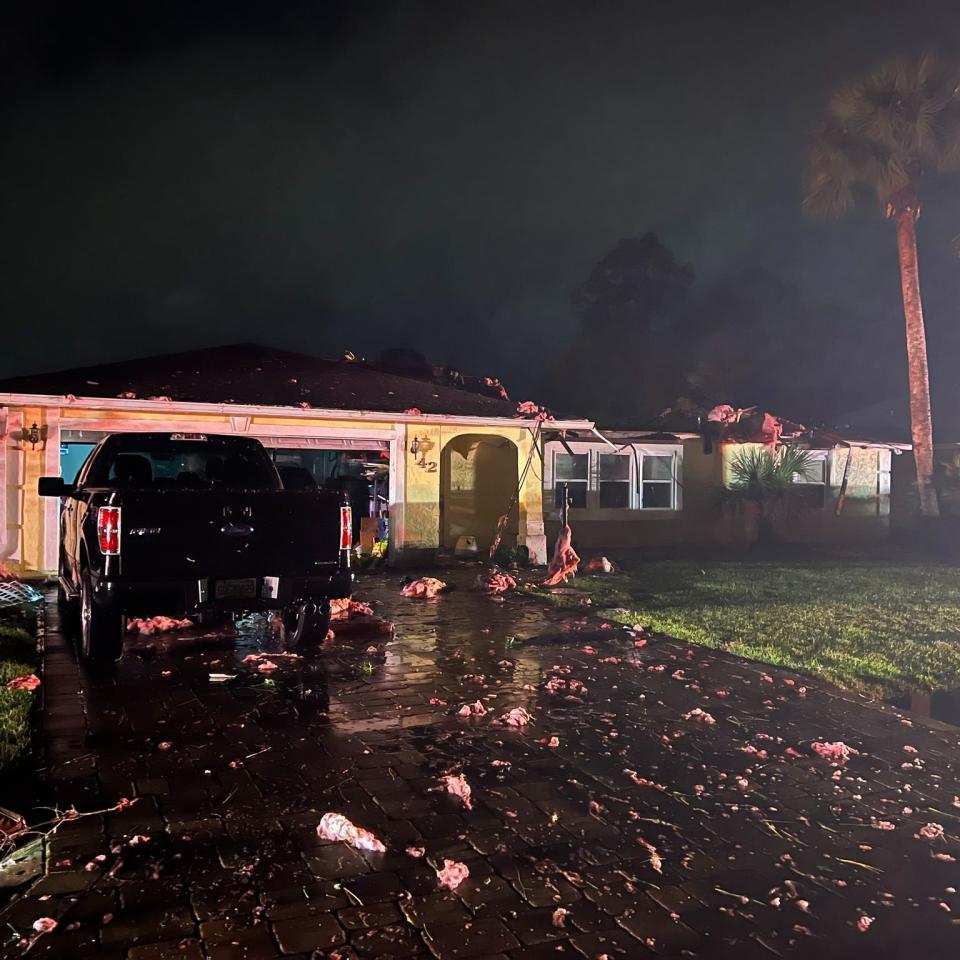
In Flagler County, the watch followed several tornado warnings issued on Thursday morning in both Volusia and Flagler, according to the National Weather Service. In Flagler, the strong tornado struck overnight in the area of the B-section of Palm Coast, according to the Flagler County Sheriff's Office.
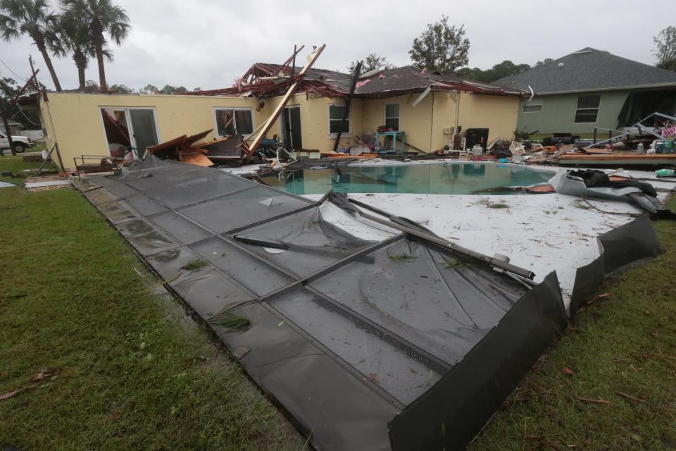
No injuries have been reported so far, the sheriff's office stated in a tweet. But there was "some significant damage," according to the sheriff's office.
Palm Coast is divided into sections or neighborhoods where all the streets start with the same letter, such as the B-section, which is among the sections of the city north of Palm Coast Parkway and along Belle Terre Parkway.
Here’s what we know about the tornado and a reminder of the distinctions between a tornado warning and a tornado watch:
What we know about the Palm Coast tornado
An EF-2 tornado with winds between 111 to 135 mph touched down in Palm Coast's B-section early Thursday morning, according to the National Weather Service in Jacksonville.
A meteorologist from that office had been dispatched by 7 a.m. Thursday to gather information at the site of the damage, said Scott Cordero, a meteorologist at the NWS in Jacksonville.
The process involves inspecting trees, buildings and other objects for clues that might indicate the direction, rotation and strength of the winds, based on the Enhanced Fujita Scale or EF Scale, a formula used to assign a tornado a ”rating” based on estimated wind speeds and related damage.
The EF scale rates tornadoes on on a scale from 0-5, with the highest level relecting gusts of more than 200 mph.
It’s a lot like meteorological detective work, Cordero said.
“A meteorologist looks for particular damage indicators, the integrity of trees and power lines, the integrity of the houses that may have been damaged. Everything from trees to roofing tiles can provide clues about the winds that did the damage, he said.
It’s a process that can last from a few hours to a few days, depending on the scope of the damage. When a determination is made, the National Weather Service posts the information on its websites and social media, he said.
Until then?
“We try to refrain from speculation until we get into the field, do the assessment and look at clues,” he said. “It’s like putting together a puzzle.”
How long were Volusia and Flagler under tornado warnings this morning?
In Flagler County, a severe thunderstorm warning that included the potential for tornadoes was issued from 4:20-4:45 a.m., ahead of the tornado strike in Palm Coast. There also were tornado warnings at 6:41 a.m., 7:36 a.m. and 7:55 a.m., the latter extending until 8:30 a.m., according to the National Weather Service in Jacksonville.
In Volusia County, there was a tornado warning in the northern portion of the county from 4:56 -5:45 a.m., according to the National Weather Service in Melbourne.
What’s the difference between a tornado warning and a tornado watch?
A tornado watch means that tornadoes are possible in and near the watch area.
Watches are issued by the U.S. government’s Storm Prediction Center in Norman, Oklahoma, in coordination with local offices of the National Weather Service for counties where tornadoes may occur. The watch area is typically large, covering numerous counties or even states.
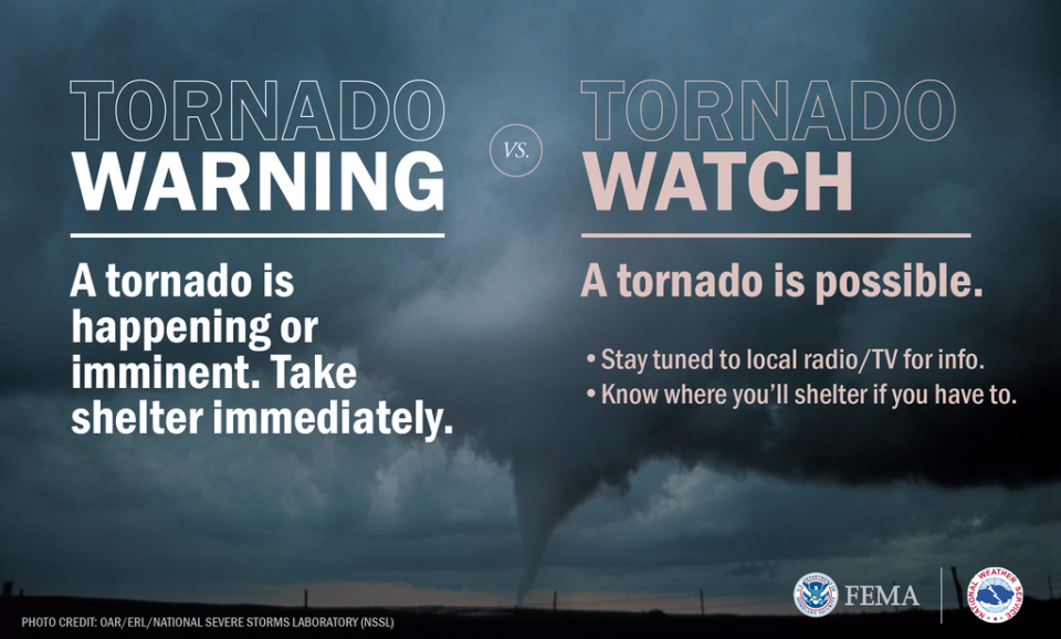
A tornado warning can be issued based off radar-indicated rotation, as observed by the National Weather Service.
Warnings are issued by the local forecast office of the National Weather Service. Such warnings typically encompass a much smaller area (around the size of a city or small county) that may be impacted by a tornado identified by a forecaster on radar or by a trained spotter watching the storm. A tornado warning means it’s time for local residents to take action to stay safe.
Such warnings can be prompted by a spotter who has sighted a tornado or by radar indicated rotation that indicate a tornado could touch down. Sometimes, radar also can indicate that a tornado already has touched down, according to meteorologists.
What should I do during a tornado warning or tornado watch?
During a tornado warning, those in affected areas are urged to take action to stay safe due to imminent danger to life and property, according to the National Weather Service.
Move to an interior room on the lowest floor of a sturdy building. Avoid windows. If in a mobile home, a vehicle, or outdoors, move to the closest substantial shelter and protect yourself from flying debris.
During a tornado watch, those in affected areas are urged to review and discuss emergency plans, check supplies and the readiness of a safe room. Be ready to act quickly if a warning is issued or you suspect a tornado is approaching. Acting early helps to save lives.
Is there the potential for more tornado activity this week?
Volusia and Flagler were under a tornado watch until 3 p.m. Thursday, according to the National Weather Service.
Numerous showers and lightning storms were forecast to affect Volusia, Flagler and Lake counties Thursday morning, spreading into Orange, Seminole, Osceola and Brevard counties by afternoon, the advisory states.
The primary storm hazards were expected to be damaging wind gusts of 50 to 60 mph, repeated rounds of heavy rainfall leading to localized flooding and frequent lightning strikes. There continued to be a tornado threat across northern sections of the area Thursday morning, but that decreased into the afternoon.
Repeated rounds of heavy rainfall will result in the potential for rainfall amounts of 1-3 inches in a short period of time. The heaviest rainfall is forecast to the north of a line that stretches from Kissimmee to Melbourne, with the primary area of concern across Volusia and north Lake counties.
Looking ahead, lightning storms remain in the forecast through Saturday, before rain chances become lower next week, according to the advisory.
This article originally appeared on The Daytona Beach News-Journal: Tornado warnings and watches: What's the difference?

