Tornadoes touch down in Jackson, Howell, Sea Girt, Weather Service confirms
JACKSON - Tornadoes touched down in Jackson, Howell and Sea Girt on Saturday night, according to the National Weather Service, leaving a path of destruction that ripped the roofs off houses, crushed cars and sheds and left trees and telephone poles blocking major roads.
Winds hovered around 60 mph on Saturday night in western Monmouth and northern Ocean County, according to the Weather Service's local storm report released late last night. Another tornado was confirmed in Cinnaminson, as well as one in Bridgeville, Delaware.
It its public information statement, the Weather Service said the Howell tornado was considered separate from the tornado that touched down in Jackson because of a "gap in the damage path between the two areas."
"We did have this line of thunderstorms come through, and sometimes when conditions are… right, you could get a brief spin up in a line of thunderstorms, which is likely what happened here," said National Weather Service meteorologist Eric Hoeflich. Those conditions are "why there are gaps in the tornado touchdowns."
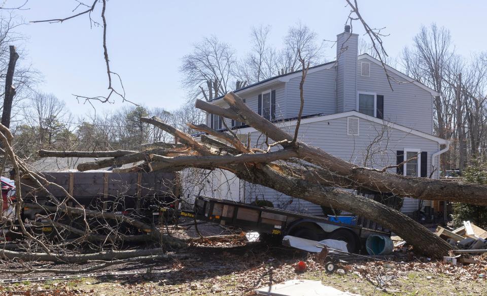
On Sunday morning, neighborhoods along West Commodore Boulevard in Jackson were reeling from the damage. In the backyard of Kevin Roe's Indiero Road home, all that was left of a metal shed was a crumpled piece of sheet metal, which had been blown into and dented his pickup truck.
More: Jet slides off runway at Monmouth Executive Airport during severe weather warnings
Atop the house, a large swatch of blue tarp covered up what had been a gaping hole, where the winds had blown the roof straight off.
"We started going down the stairs, and I looked back toward my son's room," Roe said. "The ceiling just started collapsing."
A block away on Lombardi Street, 21-year-old Dafne Guerrero thought the first tornado warning was a joke.
"There's no way a tornado is going to hit Jackson," she thought.
A few minutes later, the rain started. Then, the pelting hail. As they looked outside, the generator on a nearby telephone pole exploded. That sent them scurrying to the basement, where they heard the tree crush a pair of cars in the driveway — barely missing the house.
"You know when you're on a roller coaster, and you feel all that wind hitting you in the face," Guerrero said. "It's like that, but more intense."
We have confirmed that a tornado occurred near Jackson, NJ. For more information, please visit this link: https://t.co/XK391lcslh
Other storm surveys are currently ongoing. More information will be available shortly. #NJwx— NWS Mount Holly (@NWS_MountHolly) April 2, 2023
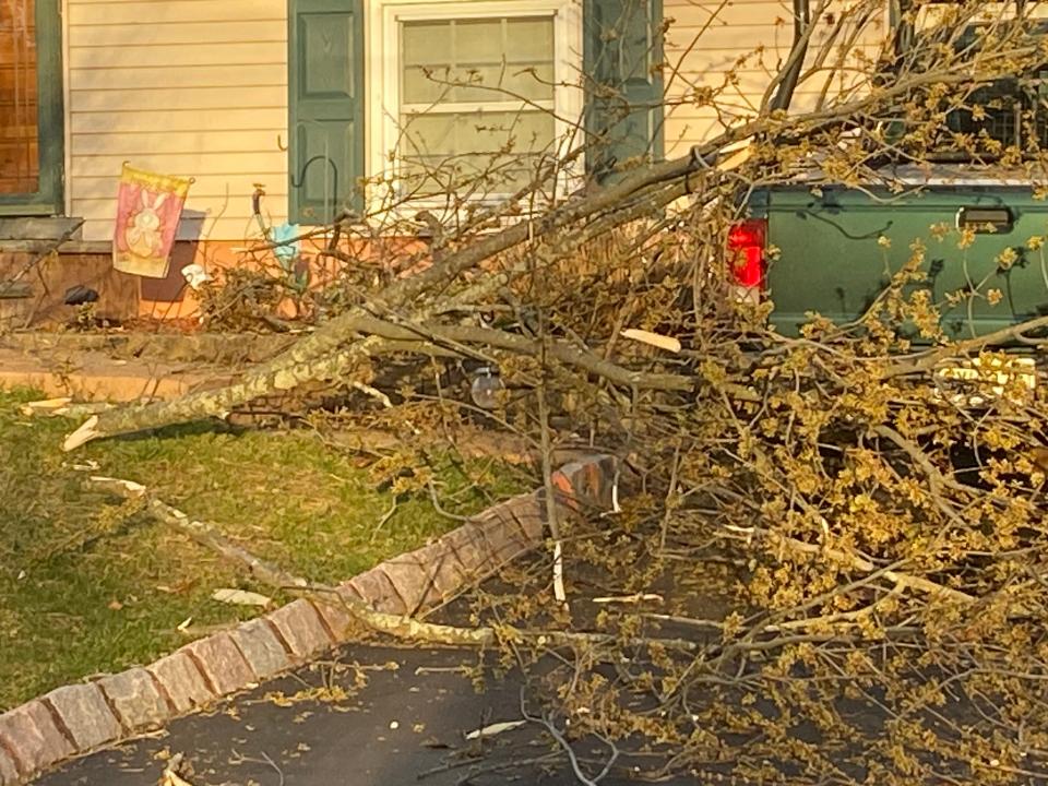
Social media was abuzz on Saturday night with video from the storm, with cyclone-like clouds, booming thundercracks and whipping winds. On Sunday morning, the multimedia gradually shifted to showing the damage — houses with blown-out roofs, uprooted trees and toppled power lines.
Over 13,000 were still without power in Monmouth and Ocean counties as of Sunday afternoon, according to Jersey Central Power & Light. Mayor Michael Reina said power is expected to be restored by Monday evening.
"There's a lot of damage to streets and personal property -- sheds completely ripped off and thrown in the middle of the roadways, trees twisted around wires," Reina said. "But I've got to look for the positives: We have no known injuries and no deaths."
The conditions in New Jersey on Saturday were ripe for a thunderstorm, National Weather Service meteorologist Sarah Johnson said. The air was already warm — high temperatures in Monmouth County topped out at 68 degrees on Saturday afternoon — as a "very intense low pressure system," which caused widespread damage in the Southeast and Midwest over the last week, came through the east coast.
More: Bad tornado season in US is getting worse: More danger in forecast after Friday's destruction.
The cold front ahead of the storm was strong enough that it produced lift, which provided "all the ingredients for a severe thunderstorm."
A tornado forms when the storm begins rotating due to wind blowing in different directions at different levels of the atmosphere, Johnson said.
"It's all the ingredients for quite a severe thunderstorm," Johnson said.
Meteorologist Steven DiMartino, owner of the forecasting service NY NJ PA Weather, said New Jersey's housing density and highway networks might be contributing to increasingly frequent storms, like the one seen Saturday night.
Tornadoes in New Jersey "used to be very unusual, but over the past five years… have become more and more frequent," he said.
Houses, sidewalks and streets radiate more heat into the atmosphere than forests and green spaces, and "that can enhance thunderstorms and lead to more intense thunderstorms and more intense convection," DiMartino said.
"We need to do a lot more research, but there seems to be a growing connection between the buildup of our infrastructure, especially around the I-95 corridor, from Philadelphia to New York City… and that enhances the rising motion in the atmosphere and increasing the potential for these storms to become stronger."
DiMartino said radar images from Saturday night showed a cyclonic rotation in the atmosphere that could have lead to tornado formation.
"This is clearly something that we're gonna see more frequently, and we need to be prepared for it," he said.
The meteorologist advised New Jersey residents to have an emergency plan that involves choosing the best place to shelter in the event of a tornado, such as a basement or an interior room, like a bathroom, that does not have windows.
"You need to be prepared for that," he said. "I see too many people go outside and try to take pictures of the funnel. You don't want to do that."
Mike Davis has spent the last decade covering New Jersey local news, marijuana legalization, transportation and a little bit of everything else. Contact him at mdavis@gannettnj.com or @byMikeDavis on Twitter.
This article originally appeared on Asbury Park Press: Tornado NJ confirmed in Jackson, Howell, Sea Girt by Weather Service

