At Least 3 Dead After Tornado Flattens Oklahoma Towns
A “large and extremely dangerous” tornado ripped through a number of communities in Oklahoma on Wednesday, tearing apart homes, forming a “debris ball” and leaving a trail of devastation in its path, killing at least three people.
It comes as the country gears up for another day of extreme weather Thursday, which is expected to extend from Austin, Texas, to St. Louis, Missouri.
The National Weather Service issued multiple warnings after the twister was triggered by numerous severe storms moving across the state. Large hailstones—said to be as big as baseballs—were also reported.
“A HP (high precipitation) cluster of storms across central Oklahoma has become messy, but continues to cycle, producing several tornadoes, some which may be strong to intense,” the National Weather Service warned Wednesday night.
“The messy nature of the supercells has led to deviant tornado motions which will likely continue until the demise of the cluster.”
Visible satellite loop of supercells bubbling across Oklahoma tonight, including the one that produced the intense tornado south of Norman in Cole. #OKwx pic.twitter.com/tIXunKNOjU
— Collin Gross (@CollinGrossWx) April 20, 2023
One of the worst hit was the community of Cole, which was struck at 7:39 p.m. Search and rescue operations continued throughout the night.
McClain County Sheriff’s Deputy Scott Gibbons confirmed two people were dead early Thursday morning in the Cole area. A third death was later confirmed by the sheriff’s office on Thursday.
The number of injured could grow as officials fear that there are people unaccounted for. “The numbers may increase, unfortunately,” Gibbons warned, adding a “ballpark” figure for the number of injured at 12.
A helicopter pilot flying for a local news station barely made it home after his windshield was damaged by the storm’s large hail, harrowing video showed Wednesday.
“We are beat the hell up,” pilot Jim Gardner, who was covering the tornado for KWTV, can be heard saying.
“I ain’t out of the damn helicopter yet,” he says. “Goddamn it.”
#BREAKING: ***SEVERE DAMAGE*** on south side of #Cole #Oklahoma as large, devastating tornado has severely damaged, if not leveled, many homes across wide area.
Here’s LIVE CHOPPER 4 COVERAGE from just seconds ago. Courtesy: KFOR #Tornado pic.twitter.com/hj8HILhJN2— Fast News Network (@fastnewsnet) April 20, 2023
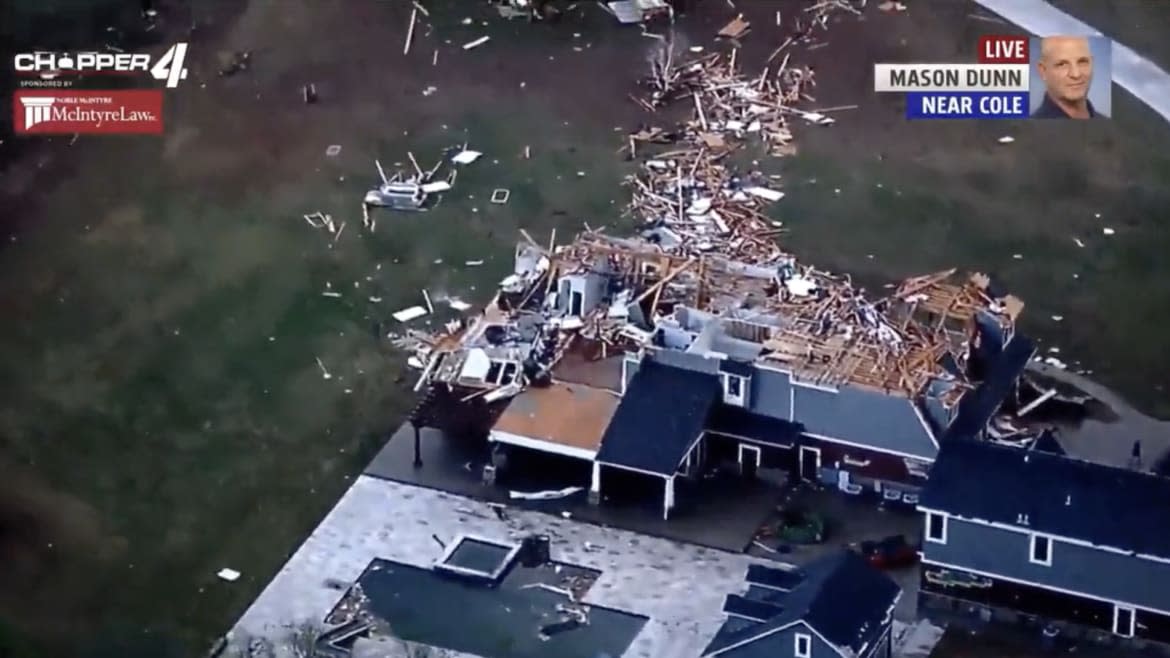
Residents in the path of the storm were urged to take shelter immediately, with pictures posted on social media showing some residences completely flattened. The number of houses damaged is currently unclear.
“It looks like this is widespread, it’s not one house here, one house here,” KFOR chopper pilot Mason Dunn says, hovering over the south side of Cole. “It looks like the damage path is going to be a long ways.”
An unidentified number of people were trapped in shelters and crews are responding to reported injuries from those entrapped, the McClain County Emergency Management service confirmed.
“There are hundreds and hundreds of first responders and other equipment going in to search these different residences, these different shelters that they have on these properties to make sure that everyone made it out OK,” Trooper Eric Foster from the Oklahoma Highway Patrol said in an update overnight. Cole was among the towns that had been hit “significantly,” citing major structural damage and downed power lines.
People have been advised to steer clear of the area to allow first responders access.
“This doesn’t even seem real,” Professional Storm Chaser Zachary Hall tweeted alongside video of a supercell near Slaughterville, Oklahoma.
Debris on the Cole, OK #tornado is now being lofted to approximately 19,000 feet. pic.twitter.com/Iv2VzS1lwz
— Marc Weinberg (@MarcWeinbergWX) April 20, 2023
In Etowah, approximately 35 miles from Cole, debris from the tornado was being launched hundreds of yards away, with reports of a “debris ball” causing further damage.
“Debris is being lofted high into the sky, showing up as jagged shapes on radar,” MyRadar Weather said.
Meanwhile students were taking shelter in a basement at Oklahoma Baptist University in neighboring Shawnee, which also copped severe damage from the tornado.
Areas also on tornado watches included Central and Eastern Iowa, northeastern Kansas and northwestern Missouri, according to the Storm Prediction Center. Threats included scattered damaging wind gusts to 65 mph, scattered large hail events to 1.5 inches in diameter and “a tornado or two.”
AccuWeather's @BillWadell recorded as a 3-inch hail hit his windshield and nearly burst into the truck in Blanchard, OK. #OKwx pic.twitter.com/LfXEzAAyQ9
— AccuWeather (@accuweather) April 20, 2023
Get the Daily Beast's biggest scoops and scandals delivered right to your inbox. Sign up now.
Stay informed and gain unlimited access to the Daily Beast's unmatched reporting. Subscribe now.

