Tornado watch throughout Virginia til 9 p.m. Monday.
6:50 p.m. National Weather Service issues Severe Weather Alert; Tornado watch.
National Weather Service issued a severe weather alert/tornado watch from 6:50 p.m. until 9 p.m. Monday for Augusta County, Staunton and Waynesboro.
The severe weather alert/tornado watch includes 30 cities and counties in Virginia, 11 cities/counties in Maryland and Washington, D.C. Tornado watch 602 remains valid until 9 p.m., NWS said.
4:48 p.m. Funnel cloud spotted in Waynesboro.
National Weather Service: Radar indicated rotation. A trained spotter reported a funnel cloud over the city of Waynesboro.
4:30 p.m. Tornado warning until 5 p.m.
Rotation is still being picked up by radar as the storm continues east into Waynesboro and Crimora.
The Pump Street gauge on Lewis Creek has crested the "Low Stage" of 25 inches, according to the city's flood system.
4:00 p.m. Tornado warning.
Tornado warning until 4:30 p.m. Take shelter. Flying debris will be dangerous to those without shelter.
3:44 p.m. Storm moving in.
A thunderstorm entering Augusta County from the west may have 70 mph winds and 1 inch sized hail.
3:20 p.m. Severe Thunderstorm Warning.
The National Weather Service has issued a Severe Thunderstorm Warning for Rockingham and Augusta counties, until 3:59 p.m.
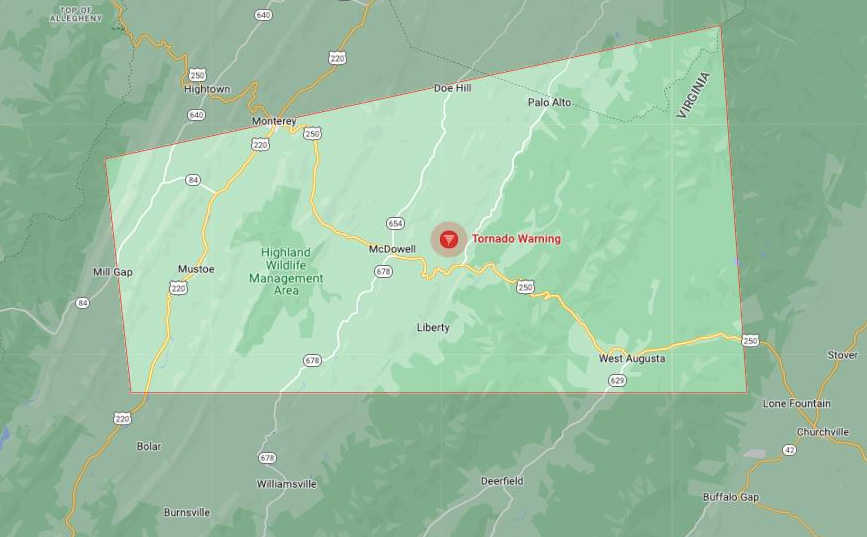
2:45 p.m. National Weather Service issues Tornado Warning.
National Weather Service issues tornado warning for western Augusta County and Highland County.
At 2:57 p.m. "a severe thunderstorm capable of producing a tornado was located 9 miles southeast of Monterey, moving east at 40 mph," according to the National Weather Service. "Radar indicated rotation." Tornado and ping pong ball size hail. Warning in effect until 3:15 pm. Take cover now, NWS said.
Tornado Watch in effect 1:20 p.m. to 9:00 p.m., per National Weather Service.
National Weather Service has issued a tornado watch from 1:20 p.m. to 9 p.m. Monday, Aug. 7, for counties and cities throughout Virginia including Augusta County and Staunton and Waynesboro.
Virginia counties include Albemarle, Amelia, Arlington, Amelia, Caroline, Chesterfield, Clarke, Culpeper, Cumberland, Essex, Fairfax, Fauquier, Fluvanna, Frederick, Goochland, Green, Hanover, Henrico, Highland, Kind, William, Loudoun, Louisa, Madison, Nelson, Nottoway, Orange, Page, Powhatan, Prince Edward, Prince William, Rappahannock, Richmond, Rockingham, Shenandoah, Spotsylvania, Stafford, Warren and Westmoreland.
Virginia cities include Alexandria, Charolottesville, Fairfax, Fall Church, Fredericksburg, Harrisonburg, Manassas, Manassas Park, Richmond, Staunton and Waynesboro.
SCHOOL: School open houses, sports practices postponed Monday in Staunton, Waynesboro, Augusta County
More: National Weather Service issues Special Weather Statement
This article originally appeared on Staunton News Leader: Tornado Warning in Virginia cities and counties per National Weather Service

