Tornado warning, tornado watch expire. Strong thunderstorms moving through Panhandle
CURRENT CONDITIONS
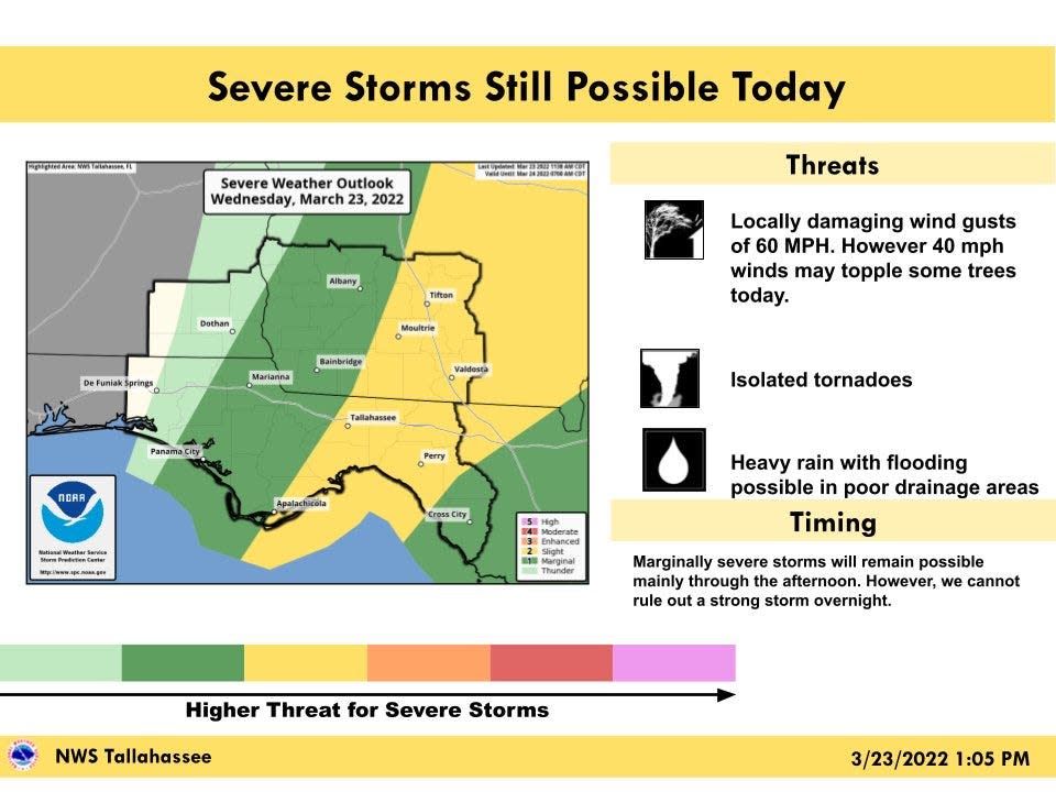
Isolated tornadoes remain threat as storms move east
1:07 p.m.: Isolated tornadoes remain a threat, with severe weather also possible from Panama City east into North Florida, according tot the National Weather Service, Tallahassee.
Threats include tornadoes, wind gusts of 60 mph and heavy rain, with flooding possible in poor drainage areas.
Wind gusts as low as 40 mph have toppled some trees due to the saturated ground.
Severe thunderstorms could pop up into tonight
1:02 p.m.: Isolated tornadoes and damaging winds are possible through tonight, according to the Storm Prediction Center.
There is a slight potential for severe thunderstorms later afternoon and tonight.
North Florida weather threat includes possible tornadoes, hail
12:49 p.m. A severe weather threat is in place for North Florida until 7 p.m. as a squall line of strong to severe thunderstorms move along the Interstate 10 corridor this afternoon, according to the National Weather Service, Jacksonville.
Threats include possible tornadoes, hail and damaging winds.
⛈️⚡ A squall line of strong to severe T'storms will traverse southeast GA, the Suwannee Valley & the I-10 corridor from the late morning through the afternoon hours
🌪️→ When taking shelter, remember this: GET IN. 🏠 GET DOWN. ⬇️ COVER UP. ⛑️#flwx #gawx #jaxwx @JaxReady pic.twitter.com/M8i4BH1h6Q— NWS Jacksonville (@NWSJacksonville) March 23, 2022
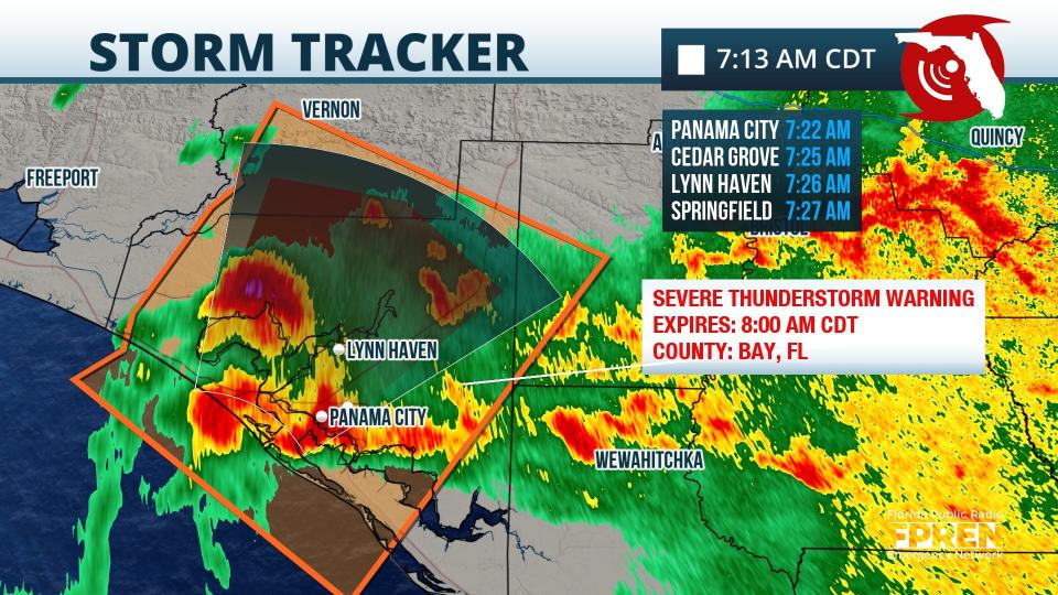
Thunderstorm capable of producing tornado near Panama City
8:16 a.m.: A severe thunderstorm capable of producing damaging winds and a tornado has moved ashore near Panama City.
The storm is moving toward the interior of Bay County.
Residents are advised to seek shelter if they are in the storm's path.
Heavy rain, strong storms moving through Bay County
8:15 a.m.: Heaviest rain and strongest storms expected to impact areas from Bay County east across the Florida Big Bend an Apalachee Bay over the next couple of hours, according to the National Weather Service, Tallahassee.
KTLH radar loop ending at 8:08 AM EDT shows showers and thunderstorms moving east across the region. The heaviest rain and strongest storms will impact the areas from Bay County east across the Florida Big Bend and Apalachee Bay over the next couple of hours. #FLWX #TLHSPOTTER pic.twitter.com/bDH0EpbHBi
— NWS Tallahassee (@NWSTallahassee) March 23, 2022
Strong winds, hail possible as severe thunderstorm moves through
7:57 a.m.: A severe thunderstorm warning has been issued for Panama City, Lynn Haven and Callaway until 8 a.m., according to the National Weather Service, Tallahassee.
Winds up to 60 mph and penny-sized hail are possible.
In addition to numerous tornado warnings in the last two days, this system featured prolonged, heavy rainfall. More than a few flash flood warnings were issued.
This map displays satellite estimated rainfall through 2 am.https://t.co/qGKF9j7WOg
MG pic.twitter.com/Gyt6OQ3Zj1— Weather.us - Weather Forecasts For Professionals (@WeatherdotUS) March 23, 2022
Tornado warning expires but line of thunderstorms bring potential for tornado
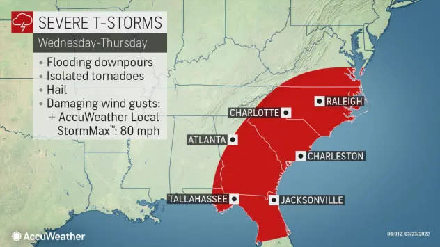
7:30 a.m.; As an early-morning tornado warning and tornado watch expired, the threat for more severe weather continues today, according to AccuWeather forecasters. A line of thunderstorms brings the potential for a few tornadoes, from northern Florida to eastern Virginia and possibly as far north as Maryland.
Residents in the Southeast should be prepared for disruptive to locally dangerous weather conditions including strong wind gusts, hail and flash floods. A couple of tornadoes are not out of the question, said AccuWeather.
Line of storms moving through Panama City, Lynn Haven
7:26 a.m.: A special weather statement has been issued for Panama City, Lynn Haven and Callaway until 7 a.m. CT.
Winds of 40 mph are possible as a line of storms moves east through the area, according to the National Weather Service, Tallahassee.
Storms expected to strengthen later this morning
6:54 a.m.: A line of thunderstorms are affecting an area from Panama City east to Tallahassee. While the intensity of the storms has diminished over the last hour, storms are forecast to restrengthen later this morning as they move east.
Squall line thunderstorms are rolling through the #Panhandle and impacting the area of #Tallahassee west to #Panama City. Intensity has waned over the past hour, but storms are expected to restrengthen later this morning as they push eastward. #FLwx pic.twitter.com/M6Eedkm4UP
— Florida Storms (@FloridaStorms) March 23, 2022
Tornado watch canceled
6:45 a.m.: The tornado watch has been canceled for all counties under the National Weather Service, Mobile, which includes Pensacola and Fort Walton Beach. The threat for severe weather has ended.
Weather radar for Panama City, Tallahassee

EARLIER STORY
A tornado warning has been issued for three Florida cities after radar indicated a tornado in the area early Wednesday morning.
The tornado warning is in effect for Miramar Beach, Freeport and Portland until 5 a.m., CT, according to the National Weather Service, Tallahassee. The communities are located between Fort Walton Beach and Panama City.
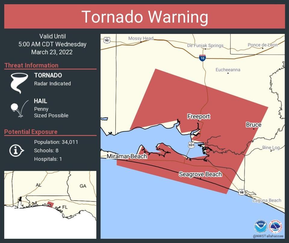
Hail up to .75 inches in diameter is possible, according to the Florida Public Radio Emergency Network.
In addition, a tornado watch has been issued for several counties in Florida's Panhandle until 6 a.m. CT.
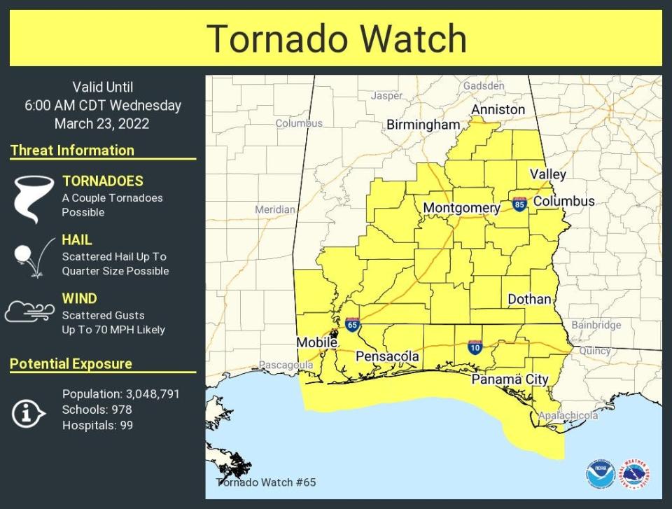
A line of strong to severe thunderstorms is moving into Florida's Panhandle and southeast Alabama. The storms are forecast to continue moving east through the day.
Severe storms moving through the area are bringing several threats, including the possibility for a couple of tornadoes, heavy rain and scattered hail up to quarter size, according to the National Weather Service, Tallahassee.
Scattered wind gusts up to 70 mph are likely.
March 23 @ 515AM ET
A line of strong to severe thunderstorms is moving into southeast Alabama and the Florida Panhandle and will push east through the day. Damaging winds and tornadoes are the main threats along with heavy rainfall. pic.twitter.com/73Bml39sn9— NWS Tallahassee (@NWSTallahassee) March 23, 2022
A flash flood warning is in effect for Okaloosa until 9:30 a.m.
Earlier forecasts as severe weather threatens
►Tornadoes, destructive winds, flooding: Bay County again in bull's-eye for severe weather
►Escambia County under tornado watch until 11 p.m. as severe storms to move through area
► Another round of severe storms could bring more isolated tornadoes to Florida
The storms moving through the Panhandle Wednesday are part of a system moving east across the U.S. A tornado hit parts of New Orleans Tuesday night.
An earlier tornado killed at least one person and left behind widespread damage in Texas and Oklahoma Tuesday.
Tornado strikes New Orleans: 1 reported dead outside city, search and rescue teams deployed
Weather radar for Pensacola, Fort Walton Beach

Local journalism like this needs your support. Consider subscribing to your local newspaper. See our current offers.
This article originally appeared on Pensacola News Journal: Florida weather forecast: Thunderstorms, potential for tornadoes

