Tornado watches issued for several Florida counties as another cold front moves through
Tornado watch issued until 3 p.m. for 3 Florida counties
10:05 a.m.: Tornado watch issued from Calhoun, Gulf and Jackson counties until 3p.m. EST.
Tornado watch issued for Leon, 5 other counties
10:05 a.m.: A tornado watch was issued until 3 p.m. EST for Leon, Franklin, Gadsden, Jefferson, Liberty and Wakulla counties.
Tornado watch extended to five more counties in Panhandle
8:55 a.m.: A tornado watch has been extended to include five more counties in the Panhandle.The tornado watch is in effect until 10 a.m. EST for Bay, Calhoun, Gulf, Jackson and Washington counties.
Earlier story
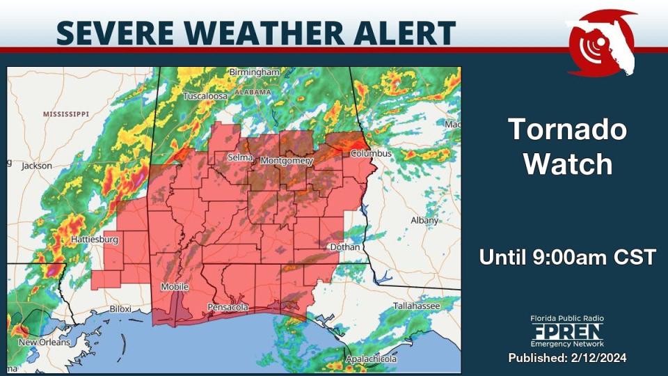
A tornado watch has been issued for several counties early Monday morning ahead of a cold front moving into Florida.
A tornado watch is in effect for Escambia, Okaloosa and Santa Rosa counties until 9 a.m. CST.
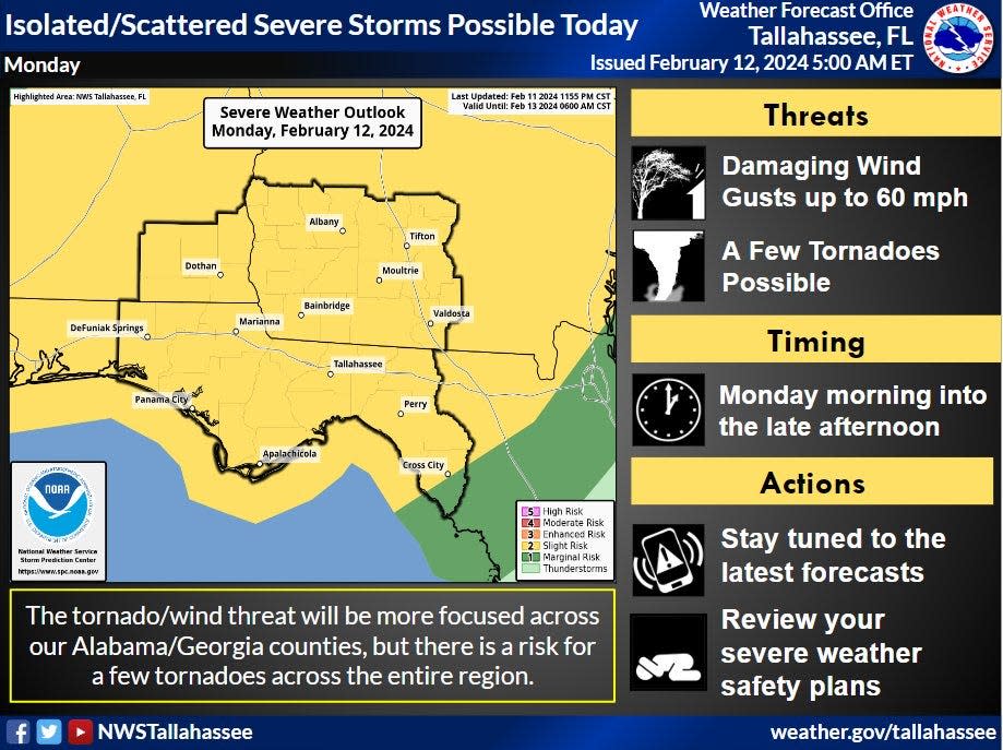
Strong to severe storms are possible, with some capable of producing an isolated tornado or two, heavy rainfall, wind gusts up to 60 mph and hail, according to the Florida Division of Emergency Services.
The storms are expected over the Panhandle and North Florida this morning before moving south.
Today's tornado watch comes just over a month after several tornadoes hit the Panhandle Jan. 9, including an EF-3 tornado that hit Bay County.
Florida weather: Cold fronts. Tornadoes. Hail. Tropical-storm-force winds. That's Florida weather in 2024
Weather watches and warnings issued across the U.S.
Weather alerts issued in Florida
Weather radar and forecast for Pensacola

Follow National Weather Service Mobile on X, formerly known as Twitter
Watches and warnings in effect
Tornado watch: until 9 a.m. CST for Escambia, Santa Rosa, Holmes, Walton and Okaloosa counties.
High surf advisory: from noon Monday to 6 a.m. Tuesday CST. Large breaking waves of 5 to 7 feet in the surf zone.
High rip current risk: Dangerous rip currents.
Forecast for Pensacola
Monday: Showers and possibly a thunderstorm before noon, then a slight chance of showers between noon and 3 p.m. Some of the storms could be severe. Patchy fog between 9 a.m. and noon. High near 69. Breezy, with a south wind 15 to 20 mph becoming west in the afternoon. Winds could gust as high as 30 mph. Chance of precipitation is 90%. New precipitation amounts between a quarter and half of an inch possible.
Monday night: Mostly cloudy, with a low around 42. West wind around 15 mph, with gusts as high as 25 mph.
Tuesday: Sunny, with a high near 60. North wind around 10 mph.
Tuesday night: Mostly clear, with a low around 40. North wind around 5 mph.
Weather radar and forecast for Tallahassee

Follow the National Weather Service Tallahassee on X, formerly known as Twitter
Storms could be strong to severe with an approaching cold front, with chances increasing as the cold front and associated storms advances into the region later this morning.
Damaging wind gusts and a few tornadoes will be the main hazard threats for today, though heavy rain and hail could be possible.
Monday: Showers and thunderstorms, mainly before 5 p.m. High near 73. Breezy, with a south southwest wind 10 to 15 mph increasing to 15 to 20 mph in the afternoon. Winds could gust as high as 30 mph. Chance of precipitation is 100%. New rainfall amounts between a half and three quarters of an inch possible.
Monday night: A 30 percent chance of showers and thunderstorms, mainly before 7 p.m. Mostly cloudy, with a low around 46. West northwest wind around 15 mph.
Tuesday: Mostly sunny, with a high near 61. Northwest wind 10 to 15 mph.
Tuesday night: Mostly clear, with a low around 36. North northwest wind 5 to 10 mph.
Weather radar and forecast for Jacksonville

Follow the National Weather Service Jacksonville on X, formerly known as Twitter
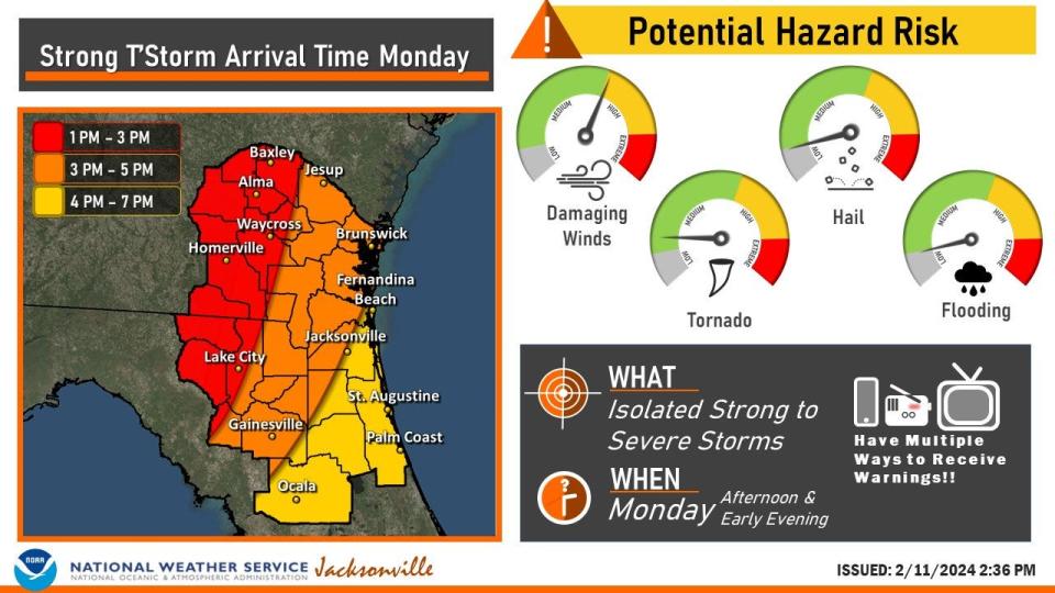
The Storm Prediction Center continues to highlight mainly northern portions of the area today in a slight risk of severe storms, with the main threat damaging winds and an isolated tornado risk. Some marginal severe hail is possible. The main threat is damaging winds but there is a low potential for a brief, isolated tornado.
Monday: A 30 percent chance of showers and thunderstorms after 3 p.m. Partly sunny, with a high near 80. Breezy, with a south wind 5 to 10 mph increasing to 13 to 18 mph in the afternoon. Winds could gust as high as 30 mph.
Monday night: Showers and thunderstorms likely, mainly before midnight. Cloudy, then gradually becoming partly cloudy, with a low around 52. Breezy, with a southwest wind 15 to 18 mph, with gusts as high as 28 mph. Chance of precipitation is 70%. New rainfall amounts between a tenth and quarter of an inch, except higher amounts possible in thunderstorms.
Tuesday: Sunny, with a high near 65. Breezy, with a west wind 13 to 17 mph, with gusts as high as 26 mph.
Tuesday night: Mostly clear, with a low around 42. Northwest wind 6 to 8 mph.
Weather radar and forecast for Daytona Beach

Follow the National Weather Service Melbourne on X, formerly known as Twitter
Gusty showers and an occasional lightning storm are forecast along and north of the I-4 corridor as a cold front approaches this evening. Coverage of isolated lightning storms dwindles after sunset while gusty showers continue to move southward through the night.
Watches and warnings in effect
High rip current risk: in effect through late tonight. Dangerous rip currents and rough surf expected.
Forecast for Daytona Beach
Monday: A 20 percent chance of showers and thunderstorms after 2 p.m. Partly sunny, with a high near 81. Windy, with a south wind 10 to 20 mph, with gusts as high as 25 mph.
Monday night: A 40 percent chance of showers and thunderstorms, mainly between 8 p.m. and 2 a.m. Mostly cloudy, with a low around 56. Windy, with a southwest wind 15 to 20 mph, with gusts as high as 30 mph.
Tuesday: Mostly sunny, with a high near 68. West northwest wind 10 to 15 mph, with gusts as high as 20 mph.
Tuesday night: Mostly clear, with a low around 48. North northwest wind 5 to 10 mph.
Weather radar and forecast for Melbourne
Follow the National Weather Service Melbourne on X, formerly known as Twitter
Isolated, gusty showers and an occasional lightning storm will be possible this afternoon as a cold front approaches east central Florida into sunset.
Watches and warnings in effect
High rip current risk: Dangerous rip currents through late tonight.
Forecast for Melbourne
Monday: Mostly sunny, with a high near 83. South wind 10 to 15 mph, with gusts as high as 25 mph.
Monday night: A slight chance of showers before 1 a.m., then isolated sprinkles between 1 a.m. and 4 a.m. Partly cloudy, with a low around 60. Windy, with a south southwest wind 15 to 20 mph, with gusts as high as 25 mph. Chance of precipitation is 20%.
Tuesday: Mostly sunny, with a high near 72. West wind 10 to 15 mph, with gusts as high as 20 mph.
Tuesday night: Mostly clear, with a low around 52. West northwest wind around 10 mph.
Weather radar and forecast for Port St. Lucie
Follow the National Weather Service Melbourne on X, formerly known as Twitter
Isolated, gusty showers and an occasional lightning storm will be possible this afternoon as a cold front approaches east central Florida into sunset.
Watches and warnings in effect
High rip current risk: Dangerous rip currents through late tonight.
Forecast for Port St. Lucie
Monday : Sunny, with a high near 84. South wind around 15 mph, with gusts as high as 25 mph.
Monday night: Isolated sprinkles between 1 a.m. and 4 a.m. Increasing clouds, with a low around 63. Windy, with a south southwest wind 15 to 20 mph, with gusts as high as 25 mph.
Tuesday: Mostly sunny, with a high near 76. West wind 10 to 15 mph, with gusts as high as 20 mph.
Tuesday night: Mostly clear, with a low around 51. West northwest wind 5 to 10 mph.
Weather radar and forecast for West Palm Beach

Follow the National Weather Service Miami on X, formerly known as Twitter
Expect breezy to gusty winds Monday, with gusts in excess of 20 mph at times. Heading into Monday night, a weakening cold front will approach the area which could bring some showers Monday night into Tuesday morning. Once it passes Tuesday morning, slightly cooler air will arrive and dry weather is expected to prevail for the day.
Watches and warnings in effect
High rip current risk: There's a high risk of rip currents for all Atlantic beaches.
Surf: Surf heights in excess of 5 feet are possible along the Palm Beaches today and tonight.
Forecast for West Palm Beach
Monday : Mostly sunny, with a high near 81. Windy, with a south wind 21 to 25 mph, with gusts as high as 33 mph.
Monday night: A chance of sprinkles between 2 a.m. and 4 a.m., then a slight chance of showers after 4 a.m. Increasing clouds, with a low around 69. Windy, with a southwest wind 21 to 26 mph, with gusts as high as 34 mph. Chance of precipitation is 20%.
Tuesday: A 10 percent chance of showers before 7 a.m. Mostly cloudy, then gradually becoming sunny, with a high near 76. Windy, with a west wind 17 to 21 mph, with gusts as high as 26 mph.
Tuesday night: Mostly clear, with a low around 60. Breezy, with a northwest wind 15 to 18 mph, with gusts as high as 24 mph.
Weather radar and forecast for Naples
Follow the National Weather Service Miami on X, formerly known as Twitter
Cooler temperatures with upper 40s over inland Southwest Florida and 50s elsewhere are forecast mid-week after the passage of the cold front. Conditions are expected to largely remain dry minus the chance for a few isolated showers as the front moves through Monday night into Tuesday morning.
Forecast for Naples
Monday: Patchy fog before 8 a.m. Otherwise, mostly sunny, with a high near 77. Breezy, with a south wind 9 to 16 mph, with gusts as high as 21 mph.
Monday night: A chance of sprinkles before 1 a.m, then a chance of showers between 1am and 4am, then a chance of sprinkles after 4 a.m. Mostly cloudy, with a low around 65. South wind 10 to 13 mph becoming northwest after midnight. Chance of precipitation is 30%.
Tuesday: A chance of sprinkles before 7am. Mostly sunny, with a high near 71. Northwest wind 9 to 14 mph, with gusts as high as 18 mph.
Tuesday night: Mostly clear, with a low around 52. North wind 8 to 10 mph.
Weather radar and forecast for Fort Myers

Follow the National Weather Service Tampa Bay on X, formerly known as Twitter
A cold front is expected to move into the eastern Gulf of Mexico this afternoon and push into the Nature Coast. The greatest storm chances will be over the Nature Coast late this afternoon and early evening, with the line of storms falling apart as they push south overnight. Temperatures will drop behind the front Tuesday under breezy northwesterly winds, turning to northerly Tuesday night.
Forecast for Fort Myers
Monday: Patchy fog before 10 a.m. Otherwise, sunny, with a high near 79. Breezy, with a south southwest wind 9 to 18 mph, with gusts as high as 26 mph.
Monday night: A chance of showers and thunderstorms before 1 a.m., then a slight chance of showers between 1 a.m. and 2 a.m. Mostly cloudy, with a low around 64. South southwest wind 9 to 14 mph becoming west northwest after midnight. Winds could gust as high as 20 mph. Chance of precipitation is 30%.
Tuesday: Sunny, with a high near 71. Northwest wind 8 to 13 mph.
Tuesday night: Mostly clear, with a low around 50. North wind 7 to 9 mph.
Weather radar and forecast for Sarasota
Follow the National Weather Service Tampa Bay on X, formerly known as Twitter
A cold front is expected to move into the eastern Gulf of Mexico this afternoon and push into the Nature Coast. The greatest storm chances will be over the Nature Coast late this afternoon and early evening, with the line of storms falling apart as they push south overnight. Temperatures will drop behind the front Tuesday under breezy northwesterly winds, turning to northerly Tuesday night.
Forecast for Sarasota
Monday: Patchy fog before 10 a.m. Otherwise, mostly sunny, with a high near 78. Windy, with a south wind 13 to 22 mph, with gusts as high as 32 mph.
Monday night: A 40 percent chance of showers and thunderstorms, mainly before 11 p.m. Mostly cloudy, with a low around 60. Breezy, with a south wind 13 to 18 mph becoming west northwest after midnight. Winds could gust as high as 29 mph.
Tuesday: Mostly sunny, with a high near 68. Breezy, with a northwest wind 13 to 15 mph, with gusts as high as 21 mph.
Tuesday night: Mostly clear, with a low around 50. North wind 8 to 10 mph.
This article originally appeared on Treasure Coast Newspapers: National Weather Service: Florida forecast, tornado watch, cold front

